Proposals and War Aims That Didn't Happen Map Thread

So in 2018 I shared with y'all a map showing a proposal by the German jurist and politician Hugo Preuß about redrawing the borders of the states of the Weimar Republic [here].

Recently I've been on a new research binge on the subject and I wanna share some fascinating new findings about proposals to redraw Germany's internal borders.

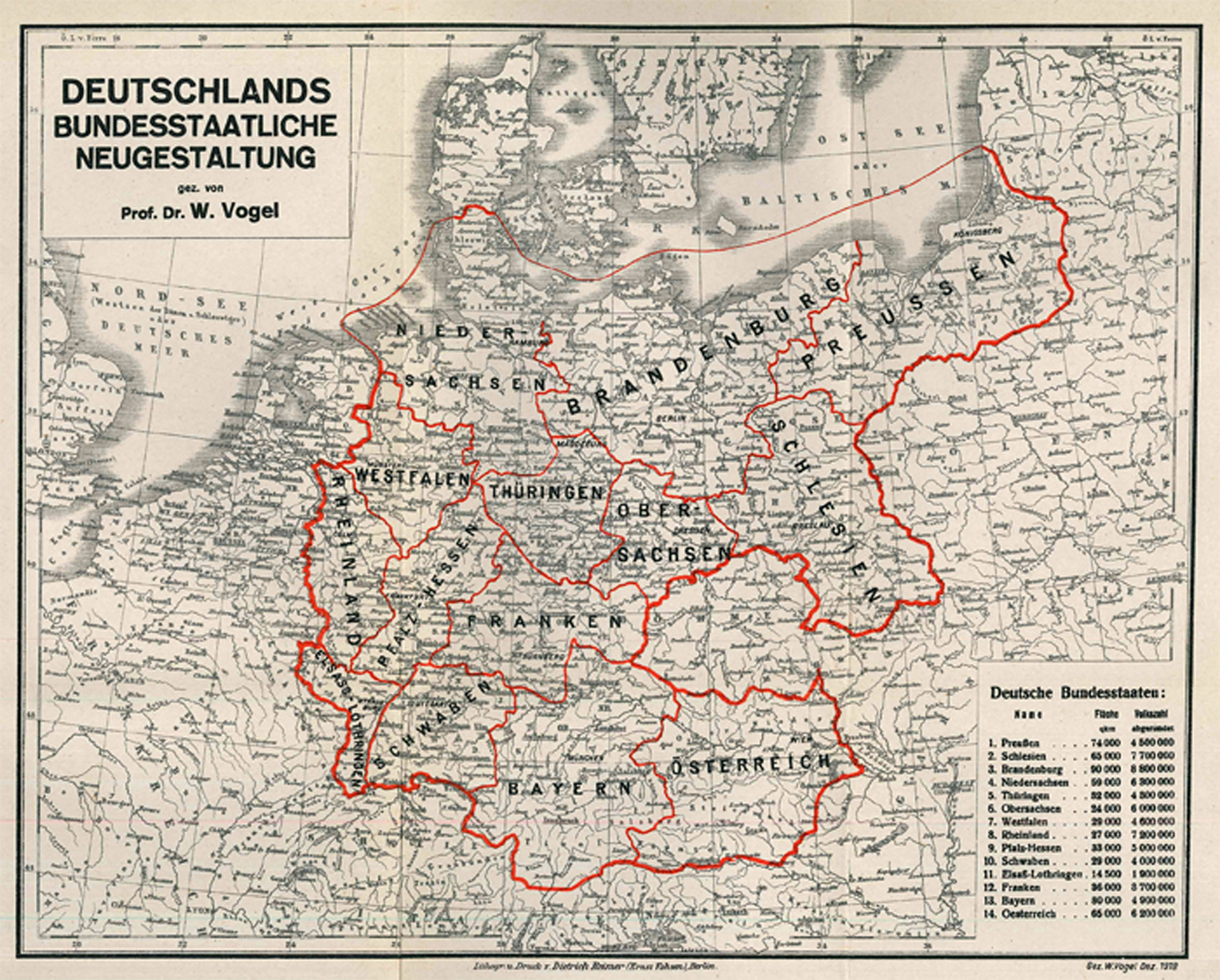
First, while I can't a high-quality version of it, I'm linking [here] a map from 1919 by the German historian Walther Vogel in a small publication titled "Deutschlands bundesstaatliche Neugestaltung", which clearly aimed to incorporate both German Austria, while also still using Germany's imperial borders elsewhere.

Secondly, there's an excellent booklet titled "Die Neugliederung Deutschlands Grundlagen - Kritik - Ziele und die Pläne zur "Reichsreform" von 1919 - 1945" by Werner Münchheimer, which I also can't find online, that covers at least five proposals at reorganizing Germany in the interwar era in great detail, including Preuß's plan. I have found an article in German [here] that shows four of them in a low resolution. To summarize these plans:
- in the Baumann-Plan (from 1923 and largely based on the ideas of an industrial engineer) included the idea that Prussia should be dismantled and that a state covering the Rhine-Ruhr industrial area should be created, almost identical to the future state of North Rhine-Westphalia
- the 1927/28 Scheu-Plan proposed to divide Germany into nine economic zones, with a highlight for me being the Baltic economic zone, covering Mecklenburg, Pommerania, and East Prussia
- the 1926 Weitzel-Plan (sometimes also known as the "Frankfurter Entwurf", or Frankfurt proprosal), modified in 1930 by the economic Erich Obst, suggested twelve states, including a partition of Bavaria into two states and the creation of a massive Rheinfranken state covering most of modern day Hesse, Rhineland-Palatinate, Saarland, and parts of Bavaria and Baden-Württemberg
- the 1943 Schulenberg-Plan (also known as the "Plan der großen Einheiten", plan of large units), which suggested the creation of eleven states, and, as its alternative name implies, most of them are big, except East Prussia and Lower Saxony, which would only consist of the southern portions of the province of Hannover and the Free State of Brunswick (while the rest of Hannover would be partitioned between the new states of Niederrhein-Westfalen and Nordsachsen)

I do hope to get my hands on a copy soon, because it's still available for purchase by the university that issues that booklet originally. We'll see. It supposedly has ten maps in its 64 pages, which would be wonderful to study more in-depth.

Lastly I wanna share four maps from an article by Rudolf Hrbeck titled "Das Problem der Neugliederung des Bundesgebietes" (the problem of reorganizing the federal territory), published in 1971, and available online by the Bundeszentrale für politische Bildung [here]. It covers the proposals to redraw German state borders in the late 60s and early 70s.

OhrqJ76.png


These first two were made in the context of the Rhineland-Palatinate state being in financial strains at the time. The first of these is the Krausse-Modell, which was proposed in 1969 by the then-minister of the interior of Baden-Württemberg. sought to merge the Hessian towns of Lampertheim & Viernheim, the former Bavarian Palatiante, and the Saarland into Baden-Württemberg, while attaching the remainder of Rhineland-Palatinate to Hesse. The justification for this was to ensure continuity between the Rhine-Main area (within Hesse) and the Rhine-Neckar area (within BaWü).

What's fascinating to me is that this proposal didn't touch the municipalities of Hirschhorn, Michelbuch, and Neckarsteinach, which are disconnected parts of the Hessian district of Bergstraße (just like Lampertheim and Viernheim), and which are very close to Heidelberg. In fact Neckarsteinach even has a light rail connection to Heidelberg and a ferry service over the Neckar river to BaWü. Also, based on when the proposal was made, I presume that the villages of Hüttenfeld, Hofheim, and Rosengarten weren't included in the transfer of Lampertheim to Baden-Württemberg, since they only were joined to Lampertheim in the late 70s.

The second proposal shown in this image, the Osswald-Modell (named after the minister president of Hesse in 1970, was intended as a counter-proposal and instead sought to integrate both the Rhine-Main area and the Rhine-Neckar area into a new state called Mittelrhein-Hessen.

Osswald also had three variants of his proposal, which were:
- merging the Palatinate to Baden-Württemberg instead of Hesse, but with the remainder of Rhineland-Palatinate and the Saarland still going to Hessen(-Mittelrhein)
- attaching the Eifel region of Rhineland-Palatinate to North Rhine-Westphalia, the Saarland and the Palatinate to Baden-Württemberg, and the remainder of the Rhineland-Palatinate to Hesse
- attaching the districts of Koblenz and Trier to North Rhine-Westphalia, the districts of Rheinhessen and Montabaur to Hesse, and the Palatinate and the Saarland to Baden-Württemberg

That third variant proprosal is very similar to a voted-down plebiscite question from 1955, and was ultimately used for another plebiscite in 1975, which also got rejected by the voters in the state of Rhineland-Palatinate.

Lastly here are two other maps. Both of these exist as and are intended to be ways to create efficient states with strong local democracies within the German state. The Wagener proposal in its relative vagueness isn't very interesting to me, however with the Schäfer-Proposal the border drawn in Lower Saxony is quite interesting, clearly trying to contain the Elbe within the new state of Norddeutschland, thus ensuring that most folks dependent on Hamburg but living in Lower Saxony become part of the same state as the Hanseatic juggernaut. It even includes Cuxhaven/Ritzebüttel, which until the Großhamburggesetz of 1937 was an exclave of the Hanseatic City of Hamburg, into that state. The article mentions that Schäfer's proposal specifically was to avoid a massive state in the north, hence the split, while Wagener wanted to avoid states with populations below 7 million people.

l3SGm4Z.png


Though if I had been in Schäfer's place, I would've attached Lippe and Minden to Nordwest, and come up with better names...
 
Last edited:
Stumbled across a German propaganda thing from World War 2 where they revealed that the Allies supposedly had plans to:

Restore the Hapsburg Monarchy as a federation of Austria, Hungary, and Yugoslavia.
Annex Istria and Trieste from Italy to the Latter Hapsburg
Annex Baden, Bavaria, and Wurttemburg to Austria
Give Salonika to the Hapsburg Empire (?)
Give France the left bank of the Rhine
Cede Prussia and Upper Silesia to Poland
Cede Schleswig-Holstein to Denmark

This Latter Hapsburg State of course would designs on Czechoslovakia and Transylvania.
HabsburgPlansApparently.png

Source:
 
Stumbled across a German propaganda thing from World War 2 where they revealed that the Allies supposedly had plans to:

Restore the Hapsburg Monarchy as a federation of Austria, Hungary, and Yugoslavia.
Annex Istria and Trieste from Italy to the Latter Hapsburg
Annex Baden, Bavaria, and Wurttemburg to Austria
Give Salonika to the Hapsburg Empire (?)
Give France the left bank of the Rhine
Cede Prussia and Upper Silesia to Poland
Cede Schleswig-Holstein to Denmark

This Latter Hapsburg State of course would designs on Czechoslovakia and Transylvania.
View attachment 897842
Source:
This is very peculiar and I can't help but wonder what kind of bullcrap Goebbels would be pontificating in regards to this.
 
I have done more research on proposed reorganizations of the states in the Weimar Republic and the Federal Republic of Germany!

Here are a few of my findings, in no particular order:

1) On September 3rd 1922 the Prussian province of Upper Silesia held a referendum on becoming its own constituent state of the Weimar Republic. The referendum had an impressive turnout of 79 percent, however only 8.9 percent of the voters were in favor of this.

2) In 1924 there was the potential of the province of Hannover to remove itself from the Free State of Prussia as its own state. Originally only the districts of Lüneburg and Stade (districts 6 and 4) were considering this, but it was ultimately expanded to include all districts except Aurich (district 1, which includes East Frisia).

531px-Reg_Bez_Provinz_Hannover_1905.png


However, before a binding plebiscite took place, a preliminary plebiscite was conducted. There the turnout was only 30.1 percent, though about 82 percent of the voters who took part voted in favor. Still, it failed due to the low turnout.

3) There were various proposals being floated on how to deal with the surviving smaller states in northern Germany after the abolition of the monarchy/monarchies. One notable proposal from the early 1920s was the merger of the Free States of Lippe and Schaumburg-Lippe with the district of Pyrmont (of Waldeck-Pyrmont), potentially expanding it further by including parts of the provinces of Hesse-Nassau (e.g. the exclave of Rinteln), Hannover, and Westphalia. However that proposal to create a state on the central Weser failed quickly due to ideological differences between the two and a half states. Pyrmont would be added to Prussia in 1921, and the Free State of Schaumburg-Lippe survived until British occupation, despite several attempts to merge it into the province of Hannover, always soundly rejected by the proud local populace. Note that if these three entities had merged, with no other additions, that its combined population would only have been about 275,000 people in 1933. Sadly I lack access to the two books that apparently are the most useful sources about this, "Lippe und seine Stellung in der Reichsreform eine wirtschafts- und verkehrsgeographische Untersuchung" by Heinrich Hunke and "Politischer Regionalismus und staatliche Neugliederung in den Anfangsjahren der Weimarer Republik in Nordwestdeutschland" by Klaus Neumann.

4) In 1919 there was a suggestion made by the government of the state of Sachsen-Altenburg, just ahead of the unification of Thuringia, that a united state of Saxony and Thuringia could be "a bridge" that could help "solve issues between Prussia and South Germany". Given how fragile the creation of Thuringia was, I'm not surprised this proposal didn't get far. My source for this is the excellent book "Der Weimarer Bundesstaat - Perspektiven einer föderalen Ordnung (1918-1933) by Anke John. She also mentions the aforementioned union of Lippe and Lippe-Schaumburg, by the way.

5) 1945 saw a rather productive movement calling for the creation of an Alpine State or Confederation that should consist out of the Swabian-Alemmanic portions of Baden and Württemberg, as well as the Bavarian core (excluding Franconia) and Austria. In some cases the French term "union alpine" was also used. Until the creation of the Federal Republic of Germany in 1949 the Bayernpartei (BP) and the Schwäbisch-Alemmannische Heimatbund were the key advocates for this project. However, due to the looming creation of the FRG, the creation of an Alemannic state within the future FRG were also popular. Jürgen Klöckler is the expert on this, though I only could skim one of his works for this, titled "Abendland - Alpenland - Alemannien". Also a useful source, which I sadly can't find anywhere where I can access it, is the 1946 publication "Schwäbisch-Alemannische Demokratie" by Otto Feger.

EDIT: I do also wanna point out that the creation of an Alemmanic state within Germany existed before 1945. For example [here] is a 1938 proposal to modify the newly-created Reichsgau Schwaben at the expense of Württemberg and Baden.

6) Here is one for which I have a contemporary map! In his 1920 book "Preussen-Deutschland oder Deutsches Deutschland?" Benedikt Schnittmann his case that the German state should be reorganized after its shift towards republicanism. A lot of academics at the time had their own ideas to reduce Germany to around 10 to 15 states, dividing up Prussia in the process. Schnittmann reprints a map created by the geographer Walther Tuckermann, which, according to his estimates, have populations between 2.2 million (Prussia) and 7.6 million (Rhineland) at the time of publication. Tuckermann and Schnittmann were both advocates to base the new German states on historic tribal and/or linguistic lines, with some account taken for geography.

eIQucBp.png


Note that I merged the map myself. In its original state it's spread over two pages and northern East Prussia is in a distinct inset.

7) Finally I wanna talk a bit about the former GDR. There were loads of proposals on how to handle reunification. A general question was whether to use reunification to reorganize Germany into several larger states, or to recreate the five historic states of the GDR (Brandenburg, Thuringia, Saxony, Mecklenburg-Vorpommern, and Berlin) and then subsequently create smaller states in the west, too. Several of the proposals compiled by Werner Rutz can be found be found over on the German Wikipedia [here}.

Ultimately a path of least resistance was chosen, but before this post ends, I wanna share two cool suggestions at redrawing the states of the GDR made in 1990 by Konrad Scherf and Lutz Zaumseil in their essay "Zur politisch-administrativen Neugliederung des Gebiets der DDR - Politische und historische, geographische und raumordnerische Aspekte".

Vier Länder Osten 3 und 4.png


The counties with the dottes lines are the ones with uncertain statuses. Note that these two proposals have eliminated the state of Saxony-Anhalt, partitioning it between Brandenburg and Saxony, and how the second proposal includes the suggestion to include all of Lusatia in Saxony, instead of dividing that cultural area between it and Brandenburg.
 
Last edited:
I have done more research on proposed reorganizations of the states in the Weimar Republic and the Federal Republic of Germany!

Here are a few of my findings, in no particular order:

1) On September 3rd 1922 the Prussian province of Upper Silesia held a referendum on becoming its own constituent state of the Weimar Republic. The referendum had an impressive turnout of 79 percent, however only 8.9 percent of the voters were in favor of this.

2) In 1924 there was the potential of the province of Hannover to remove itself from the Free State of Prussia as its own state. Originally only the districts of Lüneburg and Stade (districts 6 and 4) were considering this, but it was ultimately expanded to include all districts except Aurich (district 1, which includes East Frisia).

531px-Reg_Bez_Provinz_Hannover_1905.png


However, before a binding plebiscite took place, a preliminary plebiscite was conducted. There the turnout was only 30.1 percent, though about 82 percent of the voters who took part voted in favor. Still, it failed due to the low turnout.

3) There were various proposals being floated on how to deal with the surviving smaller states in northern Germany after the abolition of the monarchy/monarchies. One notable proposal from the early 1920s was the merger of the Free States of Lippe and Schaumburg-Lippe with the district of Pyrmont (of Waldeck-Pyrmont), potentially expanding it further by including parts of the provinces of Hesse-Nassau (e.g. the exclave of Rinteln), Hannover, and Westphalia. However that proposal to create a state on the central Weser failed quickly due to ideological differences between the two and a half states. Pyrmont would be added to Prussia in 1921, and the Free State of Schaumburg-Lippe survived until British occupation, despite several attempts to merge it into the province of Hannover, always soundly rejected by the proud local populace. Note that if these three entities had merged, with no other additions, that its combined population would only have been about 275,000 people in 1933. Sadly I lack access to the two books that apparently are the most useful sources about this, "Lippe und seine Stellung in der Reichsreform eine wirtschafts- und verkehrsgeographische Untersuchung" by Heinrich Hunke and "Politischer Regionalismus und staatliche Neugliederung in den Anfangsjahren der Weimarer Republik in Nordwestdeutschland" by Klaus Neumann.

4) In 1919 there was a suggestion made by the government of the state of Sachsen-Altenburg, just ahead of the unification of Thuringia, that a united state of Saxony and Thuringia could be "a bridge" that could help "solve issues between Prussia and South Germany". Given how fragile the creation of Thuringia was, I'm not surprised this proposal didn't get far. My source for this is the excellent book "Der Weimarer Bundesstaat - Perspektiven einer föderalen Ordnung (1918-1933) by Anke John. She also mentions the aforementioned union of Lippe and Lippe-Schaumburg, by the way.

5) 1945 saw a rather productive movement calling for the creation of an Alpine State or Confederation that should consist out of the Swabian-Alemmanic portions of Baden and Württemberg, as well as the Bavarian core (excluding Franconia) and Austria. In some cases the French term "union alpine" was also used. Until the creation of the Federal Republic of Germany in 1949 the Bayernpartei (BP) and the Schwäbisch-Alemmannische Heimatbund were the key advocates for this project. However, due to the looming creation of the FRG, the creation of an Alemannic state within the future FRG were also popular. Jürgen Klöckler is the expert on this, though I only could skim one of his works for this, titled "Abendland - Alpenland - Alemannien". Also a useful source, which I sadly can't find anywhere where I can access it, is the 1946 publication "Schwäbisch-Alemannische Demokratie" by Otto Feger.

EDIT: I do also wanna point out that the creation of an Alemmanic state within Germany existed before 1945. For example [here] is a 1938 proposal to modify the newly-created Reichsgau Schwaben at the expense of Württemberg and Baden.

6) Here is one for which I have a contemporary map! In his 1920 book "Preussen-Deutschland oder Deutsches Deutschland?" Benedikt Schnittmann his case that the German state should be reorganized after its shift towards republicanism. A lot of academics at the time had their own ideas to reduce Germany to around 10 to 15 states, dividing up Prussia in the process. Schnittmann reprints a map created by the geographer Walther Tuckermann, which, according to his estimates, have populations between 2.2 million (Prussia) and 7.6 million (Rhineland) at the time of publication. Tuckermann and Schnittmann were both advocates to base the new German states on historic tribal and/or linguistic lines, with some account taken for geography.

eIQucBp.png


Note that I merged the map myself. In its original state it's spread over two pages and northern East Prussia is in a distinct inset.

7) Finally I wanna talk a bit about the former GDR. There were loads of proposals on how to handle reunification. A general question was whether to use reunification to reorganize Germany into several larger states, or to recreate the five historic states of the GDR (Brandenburg, Thuringia, Saxony, Mecklenburg-Vorpommern, and Berlin) and then subsequently create smaller states in the west, too. Several of the proposals compiled by Werner Rutz can be found be found over on the German Wikipedia [here}.

Ultimately a path of least resistance was chosen, but before this post ends, I wanna share two cool suggestions at redrawing the states of the GDR made in 1990 by Konrad Scherf and Lutz Zaumseil in their essay "Zur politisch-administrativen Neugliederung des Gebiets der DDR - Politische und historische, geographische und raumordnerische Aspekte".

View attachment 898069

The counties with the dottes lines are the ones with uncertain statuses. Note that these two proposals have eliminated the state of Saxony-Anhalt, partitioning it between Brandenburg and Saxony, and how the second proposal includes the suggestion to include all of Lusatia in Saxony, instead of dividing that cultural area between it and Brandenburg.
Very very lovely posts of yours. Makes me wonder how you can find all those wonderful things.
I kinda like Schnittmann's idea. Although the borders are a bit rough (probably would have been refined somewhat if implemented), as well as the names.
Mark und Pommern? And then even loosing most of Vorpommern? Could have called it Brandenburg-Hinterpommern.
And also Nordsachsen feels pretty weird. The only truly Saxon lands being Lauenburg and Holstein. Even then another name might be better. Nordmark perhaps? But I like that Saxony is renamed back to Upper Saxony. Although the confusion that most non Germans already have with Lower Saxony and Saxony would be ever worse.
Westphalia is so big that I am inclined to actually call it Weser-Ems Westphalia


Wasn't there a plan to divide the Province of Saxony into a southern part south of Anhalt going to Saxony and the norther part being debated to be given to Brandenburg, Hannover or Brunswick?
Were there any plans to perhaps divide the Altmark along the Elbe, kinda how Napoleon did?
Yes, the Schnittermann-Tuckermann proposal has some weird names...

I have seen a few plans that are close to what you're describing but don't quite match:
- there's the plan by Hans Rabe (1927/28) to create what he calls "Wirtschaftsgebiete", which later got modified by a man named Lauburg apparently to divide the Province of Saxony between Brandenburg-Berlin and a "Mitteldeutschland" state mostly along the Elbe, though giving the Altmark west of the river still to Brandenburg-Berlin and giving some portions in the southeast that are east of the river (such as Wittenberg) to Mitteldeutschland
- in 1928 the state government of Saxony under the Social Democrat Max Heldt proposed a state of Mitteldeutschland consisting out of Thuringia, Hesse, Anhalt, Brunswick, Saxony, and most of the province of Saxony as a "bullwark against Prussia and centralism in the Reich"
- the Brunswicker Social Democrat (and later Nazi) Sepp Oerter proposed in 1919 the creation of a Räterepublik Braunschweig-Lüneburg with access to the North Sea coast and expansion into parts of the province of Saxony, especially within the Harz mountains, either within a united socialist Germany or a socialist state confined to the northwest of the country
- in 1990 the CDU factions in Thuringia and Hesse proposed that the two states could merge, which later got expanded upon by the the federal minister for finance, Carl-Dieter Spranger, who suggested that Lower Saxony could absorb Saxony-Anhalt and Bremen (while Mecklenburg, Schleswig-Holstein, and Hamburg would merge, same with Rheinland-Pfalz and Saarland)
Mhm, interesting.

Say, did you by chance find anything about Brunswick itself? I know about the "Eastphalia" plan together with the "Weser-Ems" plan after WW2 as an alternative to Hannover led Lower Saxony. But not much else.
Perhaps you could say the war time border changes with Prussia, but that was more based around the Reichswerke Hermann Göring in Watenstedt-Salzgitter.
Sadly nothing concrete. There are a handful of books on the subject that delve into more detail in specific regions, but I sadly can't access any of them (easily).

I'll keep looking, because this is just a subject that keeps on giving. Plus I recently found an online repository of the "Blätter für deutsche Landesgeschichte" (among other stuff) by the Bayrische Staatsbibliothek, which is super promising for this research subject.
 
3) There were various proposals being floated on how to deal with the surviving smaller states in northern Germany after the abolition of the monarchy/monarchies. One notable proposal from the early 1920s was the merger of the Free States of Lippe and Schaumburg-Lippe with the district of Pyrmont (of Waldeck-Pyrmont), potentially expanding it further by including parts of the provinces of Hesse-Nassau (e.g. the exclave of Rinteln), Hannover, and Westphalia. However that proposal to create a state on the central Weser failed quickly due to ideological differences between the two and a half states. Pyrmont would be added to Prussia in 1921, and the Free State of Schaumburg-Lippe survived until British occupation, despite several attempts to merge it into the province of Hannover, always soundly rejected by the proud local populace. Note that if these three entities had merged, with no other additions, that its combined population would only have been about 275,000 people in 1933. Sadly I lack access to the two books that apparently are the most useful sources about this, "Lippe und seine Stellung in der Reichsreform eine wirtschafts- und verkehrsgeographische Untersuchung" by Heinrich Hunke and "Politischer Regionalismus und staatliche Neugliederung in den Anfangsjahren der Weimarer Republik in Nordwestdeutschland" by Klaus Neumann.

I just wanted to add something to this and I didn't want it to get "lost" in the original post.

According to the pages I can see in Neumann's "Politischer Regionalismus und staatliche Neugliederung in den Anfangsjahren der Weimarer Republik in Nordwestdeutschland", the initial proposal for a Groß-Lippe (Greater Lippe) by the state government of the Freistaat Lippe were the following territories:

- the Free State of Lippe(-Detmold), which, it should be noted, had three exclaves that were fully surrounded by the Prussian province of Westphalia, namely the villages of Grevenhagen (today part of the city of Steinheim), Lipperode and Cappel (both part of today's Lippstadt; Lippstadt itself was a condominium with Prussia until 1850), and had a population in 1933 of 175,538 people
- the Free State of Schaumburg-Lippe, which in 1934 had a recorded population of 50,669 people
- the Landkreis of Grafschaft Schaumburg, which had come under the rule of Hessen-Kassel in 1647, became Prussian in 1867, and would become attached to the Province of Hannover in 1932, had a population of 48,148 in 1925
- the Kreis Pyrmont, part of the Free State of Waldeck-Pyrmont, which in 1910 had a population of 9,349 people and was annexed by Prussia in 1922 and joined with the Kreis Hameln to become the still-existant Landkreis Hameln-Pyrmont

It's quite likely that they may also have pushed for the town of Lügde, which historically was part of Pyrmont and which would have been fully surrounded by Groß-Lippe. Lügde had a population of 3,167 people in 1933.

Fuerstentum_Lippe_und_Fuerstentum_Schaumburg-Lippe.jpg


This 1910 map shows all of these territories quite nicely. Now, assuming that these five listed territories had merged, they would have had a combined population of around 287,000 people using 1933 census numbers. Sadly, as should be obvious, I couldn't quite find unified census data from these areas, but it's a decent estimate. It should also be considered that, potentially, Groß-Lippe might cede Cappel and Lipperode to Prussia/Westphalia (e.g. in exchange for Lügde), but given that in 2021 they had a combined population of less than 8,000 people, they wouldn't be a big loss.

If you compare that population to the other states of the Weimar Republik, then Groß-Lippe would be the fourth-smallest state in terms of population, ahead of Waldeck (55,816 in 1925, after already having ceded Pyrmont), Mecklenburg-Strelitz (110,269 in 1925), and Lübeck (127,971 in 1925), but behind Bremen (338,846) and Anhalt (351,045).

Mecklenburg-Strelitz already was also considering merging with Mecklenburg-Schwerin, but had failed to do so in 1926 due to a Reichsgericht ruling, and in 1932 briefly considered joining Prussia, before being forcibly merged with Mecklenburg-Schwerin in 1934 by the Nazis. Lübeck would cease to exist as a separate state as part of the passing of the Groß-Hamburg-Gesetz in 1937, which built upon a real desire to expand the territory of the Free and Hanseatic City of Hamburg since the establishment of a republican government in Berlin. Waldeck meanwhile would join Prussia in 1929 and become a Kreis within the province of Hesse-Nassau.

So, looking at all this context, Groß-Lippe may just become the smallest state in the Weimar Republic, probably however the second-smallest, since I believe that Lübeck may maintain its independent status in a timeline with no Nazi takeover (and I could reasonably see Lübeck expand in such a timeline with the addition of Oldenburg's Landesteil Lübeck, which in 1939 had a population of about 50,000 people).

Anyway, I'll continue watching out for more details on this, because I find it very interesting and I do have, in theory, access to some records from Schaumburg-Lippe, but sadly they are badly digitized and the "juicy bits" are notes handwritten in Sütterlin, so I can't really decipher them in a way that would allow me to remain sane.
 
Last edited:
I have done more research on proposed reorganizations of the states in the Weimar Republic and the Federal Republic of Germany!

Here are a few of my findings, in no particular order:

1) On September 3rd 1922 the Prussian province of Upper Silesia held a referendum on becoming its own constituent state of the Weimar Republic. The referendum had an impressive turnout of 79 percent, however only 8.9 percent of the voters were in favor of this.

2) In 1924 there was the potential of the province of Hannover to remove itself from the Free State of Prussia as its own state. Originally only the districts of Lüneburg and Stade (districts 6 and 4) were considering this, but it was ultimately expanded to include all districts except Aurich (district 1, which includes East Frisia).

531px-Reg_Bez_Provinz_Hannover_1905.png


However, before a binding plebiscite took place, a preliminary plebiscite was conducted. There the turnout was only 30.1 percent, though about 82 percent of the voters who took part voted in favor. Still, it failed due to the low turnout.

3) There were various proposals being floated on how to deal with the surviving smaller states in northern Germany after the abolition of the monarchy/monarchies. One notable proposal from the early 1920s was the merger of the Free States of Lippe and Schaumburg-Lippe with the district of Pyrmont (of Waldeck-Pyrmont), potentially expanding it further by including parts of the provinces of Hesse-Nassau (e.g. the exclave of Rinteln), Hannover, and Westphalia. However that proposal to create a state on the central Weser failed quickly due to ideological differences between the two and a half states. Pyrmont would be added to Prussia in 1921, and the Free State of Schaumburg-Lippe survived until British occupation, despite several attempts to merge it into the province of Hannover, always soundly rejected by the proud local populace. Note that if these three entities had merged, with no other additions, that its combined population would only have been about 275,000 people in 1933. Sadly I lack access to the two books that apparently are the most useful sources about this, "Lippe und seine Stellung in der Reichsreform eine wirtschafts- und verkehrsgeographische Untersuchung" by Heinrich Hunke and "Politischer Regionalismus und staatliche Neugliederung in den Anfangsjahren der Weimarer Republik in Nordwestdeutschland" by Klaus Neumann.

4) In 1919 there was a suggestion made by the government of the state of Sachsen-Altenburg, just ahead of the unification of Thuringia, that a united state of Saxony and Thuringia could be "a bridge" that could help "solve issues between Prussia and South Germany". Given how fragile the creation of Thuringia was, I'm not surprised this proposal didn't get far. My source for this is the excellent book "Der Weimarer Bundesstaat - Perspektiven einer föderalen Ordnung (1918-1933) by Anke John. She also mentions the aforementioned union of Lippe and Lippe-Schaumburg, by the way.

5) 1945 saw a rather productive movement calling for the creation of an Alpine State or Confederation that should consist out of the Swabian-Alemmanic portions of Baden and Württemberg, as well as the Bavarian core (excluding Franconia) and Austria. In some cases the French term "union alpine" was also used. Until the creation of the Federal Republic of Germany in 1949 the Bayernpartei (BP) and the Schwäbisch-Alemmannische Heimatbund were the key advocates for this project. However, due to the looming creation of the FRG, the creation of an Alemannic state within the future FRG were also popular. Jürgen Klöckler is the expert on this, though I only could skim one of his works for this, titled "Abendland - Alpenland - Alemannien". Also a useful source, which I sadly can't find anywhere where I can access it, is the 1946 publication "Schwäbisch-Alemannische Demokratie" by Otto Feger.

EDIT: I do also wanna point out that the creation of an Alemmanic state within Germany existed before 1945. For example [here] is a 1938 proposal to modify the newly-created Reichsgau Schwaben at the expense of Württemberg and Baden.

6) Here is one for which I have a contemporary map! In his 1920 book "Preussen-Deutschland oder Deutsches Deutschland?" Benedikt Schnittmann his case that the German state should be reorganized after its shift towards republicanism. A lot of academics at the time had their own ideas to reduce Germany to around 10 to 15 states, dividing up Prussia in the process. Schnittmann reprints a map created by the geographer Walther Tuckermann, which, according to his estimates, have populations between 2.2 million (Prussia) and 7.6 million (Rhineland) at the time of publication. Tuckermann and Schnittmann were both advocates to base the new German states on historic tribal and/or linguistic lines, with some account taken for geography.

eIQucBp.png


Note that I merged the map myself. In its original state it's spread over two pages and northern East Prussia is in a distinct inset.

7) Finally I wanna talk a bit about the former GDR. There were loads of proposals on how to handle reunification. A general question was whether to use reunification to reorganize Germany into several larger states, or to recreate the five historic states of the GDR (Brandenburg, Thuringia, Saxony, Mecklenburg-Vorpommern, and Berlin) and then subsequently create smaller states in the west, too. Several of the proposals compiled by Werner Rutz can be found be found over on the German Wikipedia [here}.

Ultimately a path of least resistance was chosen, but before this post ends, I wanna share two cool suggestions at redrawing the states of the GDR made in 1990 by Konrad Scherf and Lutz Zaumseil in their essay "Zur politisch-administrativen Neugliederung des Gebiets der DDR - Politische und historische, geographische und raumordnerische Aspekte".

View attachment 898069

The counties with the dottes lines are the ones with uncertain statuses. Note that these two proposals have eliminated the state of Saxony-Anhalt, partitioning it between Brandenburg and Saxony, and how the second proposal includes the suggestion to include all of Lusatia in Saxony, instead of dividing that cultural area between it and Brandenburg.
You might find this cool, there's a page on the HLB going over some Reichsreform proposals including the famous Hugo Preuß one, but they also have this pretty goofy one:
Deutschlands_bundesstaatliche_Neugestaltung.jpg
 
You might find this cool, there's a page on the HLB going over some Reichsreform proposals including the famous Hugo Preuß one, but they also have this pretty goofy one:
ah, yes, Bavaria, and the historic Bavarian cities of, for example, Innsbruck. Huh? Nuremberg? No, that's Franconia and Franconia ALONE.

oh and by the way Magdeburg is Thuringia, Posen is Silesia, and all of Pomerania is Brandenburg.

this is a very silly map
 
You might find this cool, there's a page on the HLB going over some Reichsreform proposals including the famous Hugo Preuß one, but they also have this pretty goofy one:
Yeah, I've seen that one. Didn't include it in my posts because the resolution is just terrible and Vogel's proposal isn't explained there (and I can't find a copy of the book)...
It's also where I first heard about the source "Die Neugliederung Deutschlands. Grundlage-Kritik-Ziele und die Pläne zur Reichsreform von 1919-1945" by W. Münchheimer, which I'll hopefully own soon-ish.
ah, yes, Bavaria, and the historic Bavarian cities of, for example, Innsbruck. Huh? Nuremberg? No, that's Franconia and Franconia ALONE.

oh and by the way Magdeburg is Thuringia, Posen is Silesia, and all of Pomerania is Brandenburg.

this is a very silly map
I have seen several proposals that specifically mention that, in order to build an equitable Germany, not only Prussia would need to be broken up, but also Bavaria. So creating a Franconian state makes perfect sense, and it includes several territories that would/were considered Franconian in Thuringia and Württemberg, as well as the Czech Egerland, which Bavaria actually held claims to.
Attaching Tyrol to Bavaria is also an old idea (hell, look at Napoleonic Bavaria), and it works especially well if you were aiming to create similar-sized states and were seeking to prevent the old big three of Prussia, Austria, and Bavaria from gaining any prominence. Tyrol is even easy to reach from Bavaria.

Attaching Pomerania to Brandenburg was also a common idea, especially since both regions are rural, have been ruled together for ages, and had similar dialects.

Lastly while I do agree that Magdeburg going to Thuringia is odd, partitioning Posen likely would've served as a gerrymander to prevent Polish domination in a single state. Though Prussia would likely have a very strong Polish voting bloc in this scenario.

Edit: By the way, I also have another drop of stuff on this, and I'll post it this weekend
 
Last edited:
Fascinating idea. Would it have been Togo or Cameroon? Namibia is a wash; obviously the British would take that. And east Africa is going to be “too far to ship them,” particularly considering the transatlantic slave trade was taken predominantly from the western coast. I’ve known about the 1820-60 era repatriation efforts, but I had no idea there were any scholarly efforts to do so going into the 1900s. And sure there’s the Pan-Africa movement and Malcolm X’s desires, but…
 
Fascinating idea. Would it have been Togo or Cameroon? Namibia is a wash; obviously the British would take that. And east Africa is going to be “too far to ship them,” particularly considering the transatlantic slave trade was taken predominantly from the western coast. I’ve known about the 1820-60 era repatriation efforts, but I had no idea there were any scholarly efforts to do so going into the 1900s. And sure there’s the Pan-Africa movement and Malcolm X’s desires, but…
I would guess Cameroon, and already I can see another timeline forming in my head :p
 
Top