Just keep supplying us with those sweet, sweet maps, and all is forgiven.What do you mean, other places than the middle east and africa exist?
You are using an out of date browser. It may not display this or other websites correctly.
You should upgrade or use an alternative browser.
You should upgrade or use an alternative browser.
The NextGen OTL Worlda Series
- Thread starter hadaril
- Start date
Could/would you possibly take a quick look and tell me whether any major details currently shown for those parts of the world on my '1749' map above need changing?What do you mean, other places than the middle east and africa exist?
Last edited:
3. Ryukyu Islands recoloured from 'Japan' to 'Japan with more autonomy', & placed in a box that shows the overlapping Japanese & Chinese claims to overlordship. Also, I've left the southern islands -- Japanese nowadays IOTL, and shown as Japanese on the earlier version of the map -- out of this kingdom, which I think is accurate.
Hi, regarding Ryukyu, I don't think the Yakushima island is part of Ryukyu so it should be colored "Japan".
<looks>Hi, regarding Ryukyu, I don't think the Yakushima island is part of Ryukyu so it should be colored "Japan".
You're right: Thank you. I'll fix that detail, too.
No new colour for Lorraine, after all: Not really enough room for one, and I couldn't decide which NCS shade would be most appropriate anyway.In Europe, I might give the Duchy of Lorraine a distinctive colour rather than just leaving it in the generic "HRE member" shade.
EDIT (9pm, GMT):
Much of Chukotka (north-eastern Siberia) is actually outside of Russian control at this stage, and should be shown as such.
The status of the Kurile Islands, north of Japan, might also need considering.
Chukotka shown as still largely outside Russian rule, but I offer no guarantee whatsoever for the boundary's accuracy: I found a WorldA map for 1750 somewhere in this thread, and took some parts of that border from there, but modified its south-western corner because Wikipedia placed a Russian outpost in that area at that time (and also said that Kamchatka had been occupied by Russia by then, although the 1750 map showed that area -- with what looked suspiciously like its Russian-set administrative boundary -- as also still free..). I've used the NCS 'Siberian' colour for the Chukchi, but in its "with more autonomy" shade to reflect the absence of any unified government among that people.
Kurile Islands re-coloured, the northernmost one (adjacent to Kamchatka) as Russian and the southern ones as "Japan, with second-level autonomy" because those are -- like the southern tip of Sakhalin, for which I'd also used that shade -- loosely controlled by just one Japanese clan rather than by the Shogunate.
Hi, regarding Ryukyu, I don't think the Yakushima island is part of Ryukyu so it should be colored "Japan".
Okay, that's been fixed. Also, on checking further, I found that the southernmost group in the Ryukyu chain was part of the kingdom, after all, so I've recoloured the islands there (those of them that were large enough to show as more than just black dots, anyway) as well. The 'box' around the kingdom has been redrawn to take account of those changes, although there are some outlying islands here & there whose ownership I'm not sure about.
_______________________________________________________________________________________
Also done:
Portuguese trading settlement at Macau, in southern China, added. Yes, it's small and isn't yet actually owned by Portugal, but then those points apply to the Dutch trading outpost at Deshima in Japan as well and the earlier-made map already showed that.
I've recoloured Tuscany, again, this time from 'Austria' to 'Bohemia' (which is quite a similar colour anyway) reflecting the facts that it wasn't actually part of the Hapsburg domains as such (Francis having acquired it separately, in exchange for Lorraine) at that point and that Francis was also the elected king of Bohemia. Possibly 'Austria but with more autonomy' would be a better choice, but that seems more appropriate for later generations when its Grand Dukes are descendants of Francis by the Austrian Archduchess Maria Theresa.
________________________________________________________________________________
Question:
Is the colour used for part of the area between British and French colonies (south of the Great Lakes & St Lawrence), which I presume indicates organised native tribes, from the NCS chart (where I can't find it) or from somewhere else instead?
Last edited:
It represents the claimed territory of the Haudenosaunee League.________________________________________________________________________________
Question:
Is the colour used for part of the area between British and French colonies (south of the Great Lakes & St Lawrence), which I presume indicates organised native tribes, from the NCS chart (where I can't find it) or from somewhere else instead?
I have started work already, Rest In Peace Literally half of the plans here. Also I am really struggling with school but...All hail @hadaril ! Thanks for bringing the WorldA into the next generation!
During the modern era (post World War II), we would definitely need:
- 1949
- 1950
- 1953 (End of the Korean War)
- 1959 and/or 1961
- 1962
- 1968
- 1970
- 1975
- 1983 (Petrov incident, Able Archer)
- 1988
- 1989
- 1990
- 1991
- 2000
- 2001
- 2003
- 2011 (Arab Spring)
- 2014 (Crimea)
I'm currently working on a Iran patch for 1747, so that should be useful (though Iran was in flux at this point so the map might not map very well)Now, does anybody else here have any other changes that they think should be made? As I said before, I know very little about what was happening in this period in parts of Asia or most of Sub-Saharan Africa...
Thank you. I thought that the northern end of that strip was certainly theirs, but hadn't realised that their claims ran quite so far south and consequently wondered whether some other group or groups -- the 'Overhill' branch of the Cherokees, for example -- had also been included there. Do you know whether this colour is regarded as "standard" for them here, even though it apparently isn't on the NCS chart? If it isn't "standard" then I might replace it with the NCS 'North America. Primary Natives' colour instead.It represents the claimed territory of the Haudenosaunee League.
Thank you.I'm currently working on a Iran patch for 1747, so that should be useful (though Iran was in flux at this point so the map might not map very well)
At the very least, seeing how it compares to the current version will tell me what details about that area I need to research further.
____________________________________________________________________________
Today I'll be reading up a bit more on South-East Asia, and looking for accurate maps of the lands around there.
____________________________________________________________________________
Oh, and yesterday I did add a dot on the Tuscan coast to show the Principality of Piombino, after all: It's the one opposite Elba, in the same colour that I'd already used for the Duchy of Sora (on the Naples/Papal border) -- which is 'Naples with more autonomy' -- as they currently share the same ruler.
Last edited:
Don't suppose anyone has a map of the Russian Empire subdivisions around WWI?
There's a labelled Q-bam in this post:Don't suppose anyone has a map of the Russian Empire subdivisions around WWI?
The NextGen OTL Worlda Series
I have an adaptation on my PC, you'd just have to wait a couple hours works for me
www.alternatehistory.com
They're not my creations, BTW. I just happened to have a copy of them saved.
I was hoping for it in WorldA format - I know there used to be one but for some reason it was never updated to the new basemaps.There's a labelled Q-bam in this post:
The NextGen OTL Worlda Series
I have an adaptation on my PC, you'd just have to wait a couple hours works for mewww.alternatehistory.com
They're not my creations, BTW. I just happened to have a copy of them saved.
This one has it in 4.0 (not very visible):I was hoping for it in WorldA format - I know there used to be one but for some reason it was never updated to the new basemaps.
The NextGen OTL Worlda Series
I have an adaptation on my PC, you'd just have to wait a couple hours works for me
www.alternatehistory.com
That's the bitch, thanks very much!This one has it in 4.0 (not very visible):
The NextGen OTL Worlda Series
I have an adaptation on my PC, you'd just have to wait a couple hours works for mewww.alternatehistory.com
Don't suppose anyone has a map of the Russian Empire subdivisions around WWI?
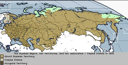
Russia 1900 by LibraryofAlexandria on DeviantArt
Few patches from a basemap @HeX sent me. I believe they might be a fan of US history, but you can never be sure.
Share: