Works even better as an abstract Great Britain, though the smaller island would have to be moved to the other side.As far as maps without Ireland go, this was seen at the wall of a school (though Reddit didn't specify which school)
View attachment 883306
Almost lucky that they have placed a few city names there, because without them I might not have suspected this to be a map of Europe.
And come to think of it, if it had been turned 90 degrees and replace Rome with Florida, Reykjavik with Hawaii and Warsaw with Denver it could just as well be an abstract map of North America. Here, I dabbled a bit in Paint:
View attachment 883307
Heck, turning it 90 degress in the other way it then could do as an abstract Great Britain, though i guess I will spare you my crude MSPaint skills in this case.
You are using an out of date browser. It may not display this or other websites correctly.
You should upgrade or use an alternative browser.
You should upgrade or use an alternative browser.
Return of Horrible Educational Maps
- Thread starter Westphalian
- Start date
Someone's created a mosaic earth. Because that's the only way this makes any sense
I love the fact that some things are accurate (such as Walvis Bay being shown as a separate enclave) but overall this proves that putting a load of correct (/ nearly correct) things together doesn't make the whole thing good...
Was this written by a Hungarian-Bulgarian-Brazilian?
Has Bulgaria ever bordered Albania? (say, in the last 300 years)Was this written by a Hungarian-Bulgarian-Brazilian?
The Treaty of San Stefano tried to do that. Before...probably during the period of the First Bulgarian EmpireHas Bulgaria ever bordered Albania? (say, in the last 300 years)
Yes.Has Bulgaria ever bordered Albania? (say, in the last 300 years)
Something in my mind get died when I saw this.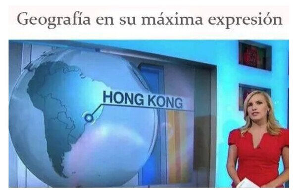
"Geography in its max expression"
Something in my mind get died when I saw this.
Then to soothe your mind have a webfind on which the labels (amongst which is also Hong Kong) are at least on the right continent... albeit that's about as much accuracy you gonna get from it.
Special charm point: Korea being labeled and almost placed in the right location, but without there being a, you know, Korean peninsula...
Well, that's one way of implementing a new Northern Ireland protocol - have sea between N.Ireland and the Republic...Then to soothe your mind have a webfind on which the labels (amongst which is also Hong Kong) are at least on the right continent... albeit that's about as much accuracy you gonna get from it.
View attachment 885894
Special charm point: Korea being labeled and almost placed in the right location, but without there being a, you know, Korean peninsula...
And there's not much chance of the new widened RedSuezCanalSea being blocked, though it will get less use, I think, due to the closure of the Gibraltar Strait.
... I could go on, but I can feel my sanity draining away...
Ah, Vietnam, that land just east of Borneo...Then to soothe your mind have a webfind on which the labels (amongst which is also Hong Kong) are at least on the right continent... albeit that's about as much accuracy you gonna get from it.
View attachment 885894
Special charm point: Korea being labeled and almost placed in the right location, but without there being a, you know, Korean peninsula...
I saw it while I was working on my map, so I wasn’t inspired by that but it certainly is one example of why I made my own lolDid this inspire @DaniCBP 's recent coverage of the same topic, or was it a coincidence?
Did this inspire @DaniCBP 's recent coverage of the same topic, or was it a coincidence?
I think it was just some coincidence. But depicting colonial empires seems to be a difficult task, especially when the map maker wants to cover several centuries at once.
Next map (also from reddit) very related:
UuuuuuuuuuuuuuuuurghI think it was just some coincidence. But depicting colonial empires seems to be a difficult task, especially when the map maker wants to cover several centuries at once.
Next map (also from reddit) very related:
View attachment 886252
Share: