If the Rockies become fairly wet, do you think those lakes would appear again? Or has the Crust lay out changed too much for that?.They existed waaaaay back, in the Eocene according to the image. Lake Bonneville formed further west, in the Basin and Range country, a type of geographical feature that wasn't even properly formed back then, as most of the distension that created it happened after the Eocene. If only, the lakes on the image seem to have formed between the eastern border of the Great Basin (Wasatch Range) and the Rocky Mountains, so no relation imo.
You are using an out of date browser. It may not display this or other websites correctly.
You should upgrade or use an alternative browser.
You should upgrade or use an alternative browser.
Planetocopia Map Thread
- Thread starter Lowtuff
- Start date
I began to make Robinson Seapole cover map but paused on the long time These are two very WIP mapsI'd like to do something with Seapole. Would someone be nice enough to cover the big Winkel-Tripel map on the WDB website to equirectangular? Many thanks!


Africa too close to the North Pole. Centrsl longitude should be -14, not -10Hey, Seapole already done.

Pliocene surface reconstruction with paleo-drainage.
We extracted paleo-watershed boundaries and river longitudinal (long) profiles following the five dominant paleo-rivers denoted in solid blue lines.

Modern Bedrock topography of the Laurentide region.
from
For other people trying to do never glaciated north america
Last edited:
Problem - that map is in Robinson. I want equirectangular.Hey, Seapole already done.
They could exist, but if the main winds now come from the ocean the air masses have to cross the Sierra Nevada, then the myriad ranges of Nevada, and then the Wasatch Range. Difficult, but not impossible. If they exist they would certainly be smaller.If the Rockies become fairly wet, do you think those lakes would appear again? Or has the Crust lay out changed too much for that?.
Anyway, in the original Jaredia there's a giant Island in the Caspian-Aral. Which is an issue cuz the Caspian drains into the Black Sea and that into the Mediterranean before the sea level gets that high. Now, if the Caspian drained into the Ob river and that into the Arctic then that can be justified so, how do we block the Bosphorus up to the elevation of Istanbul?
1. The Glacier in Anatolia directly blocking the Bosphorus which I think is weak and dangerous for the TL, a slight warming and the compressed salty ice turns liquid from the bottom of the strait and I am not sure it would even freeze. On the other hand, it is helped along in that the Mediterranean is completely protected from warm currents from the world Ocean so would be extremely cold year around (like our Arctic) but I still have my doubts about marine permafrost, under pressure and in contact with the sea.
2. Some random crustal shananigens or erosion under the Anatolian Glacier when it was larger blocking the Dardanles and/or Bosphorus which I also think is weak cuz we don't need one basin to be eroded lower like in North America's extension of the mississippi but one basin't edge/trough to be higher and I don't know of a precidence for glacial crustal deformation or erosion to just pile up stability. Best I can think of here that is fairly stable and I can explain is the cycle of greater loading and unloading on the Crust causes by glaciers growing and shrinking induces some Neogene or Paleogene basaltic flow volcanism in Bithynia that floods over and closes the Bosphorus and associated low lands.

3. Final excuse I am thinking of, buying into the theory that catastrophic floods created the Bosphorus and no catastrophic floods in TTL. May be the weakest as water probs flowed through the Caspian into the Black Sea to the Mediterranean like up to 50,000 years ago before most of the catastrophic floods hypothesis so even if it wasn't 30ish metres down then, it was pretty down already.
Maybe a combination of all 3 are what I need. Anyways, all the above would mean that the Black Sea and Caspian would share the same water level, a water level that'll extend all the way to the lower Danube and even Hungarian plain. Something that I am not too fond of as it wouldn't look Jaredia.
Anyways, this would have the important feature that the Black Sea drains into the Caspian. That's the only way I can be sure it'll be that big. We can also have a similar effect by having the Gibraltar remain stuck, Ala Messinian Salinity crisis or just erosion from Africa and Spain. Because the Ice melt from Africa and Europe would certainly be enough to keep the basins filled.
Such would be the greatest timeline here, I think.
--
So, I was thinking of how to make it so that the through of the Black basin and Caspian Sea basins would be higher without glaciation. I once heard glaciation extended a bit into kyrgyzstan is that enough of an excuse? I don't think so again, because of the point that weakened my 3. excuse in the last part. But if it works, we could have different water levels between the Caspian(higher) and Black Sea(lower) and look more Jaredia. Hell, I won't need to explain away the bosphorus or dardanles which can remain same as OTL.
Or should I just accept the generally lower levels of the Caspian here? And just have have it drain into a similarly normal Black Sea to the Ocean?.
So what do you guys think I should go with for the Neo-Tethys lakes system?.

1. The Glacier in Anatolia directly blocking the Bosphorus which I think is weak and dangerous for the TL, a slight warming and the compressed salty ice turns liquid from the bottom of the strait and I am not sure it would even freeze. On the other hand, it is helped along in that the Mediterranean is completely protected from warm currents from the world Ocean so would be extremely cold year around (like our Arctic) but I still have my doubts about marine permafrost, under pressure and in contact with the sea.
2. Some random crustal shananigens or erosion under the Anatolian Glacier when it was larger blocking the Dardanles and/or Bosphorus which I also think is weak cuz we don't need one basin to be eroded lower like in North America's extension of the mississippi but one basin't edge/trough to be higher and I don't know of a precidence for glacial crustal deformation or erosion to just pile up stability. Best I can think of here that is fairly stable and I can explain is the cycle of greater loading and unloading on the Crust causes by glaciers growing and shrinking induces some Neogene or Paleogene basaltic flow volcanism in Bithynia that floods over and closes the Bosphorus and associated low lands.
3. Final excuse I am thinking of, buying into the theory that catastrophic floods created the Bosphorus and no catastrophic floods in TTL. May be the weakest as water probs flowed through the Caspian into the Black Sea to the Mediterranean like up to 50,000 years ago before most of the catastrophic floods hypothesis so even if it wasn't 30ish metres down then, it was pretty down already.
Maybe a combination of all 3 are what I need. Anyways, all the above would mean that the Black Sea and Caspian would share the same water level, a water level that'll extend all the way to the lower Danube and even Hungarian plain. Something that I am not too fond of as it wouldn't look Jaredia.
Anyways, this would have the important feature that the Black Sea drains into the Caspian. That's the only way I can be sure it'll be that big. We can also have a similar effect by having the Gibraltar remain stuck, Ala Messinian Salinity crisis or just erosion from Africa and Spain. Because the Ice melt from Africa and Europe would certainly be enough to keep the basins filled.
Such would be the greatest timeline here, I think.
--
So, I was thinking of how to make it so that the through of the Black basin and Caspian Sea basins would be higher without glaciation. I once heard glaciation extended a bit into kyrgyzstan is that enough of an excuse? I don't think so again, because of the point that weakened my 3. excuse in the last part. But if it works, we could have different water levels between the Caspian(higher) and Black Sea(lower) and look more Jaredia. Hell, I won't need to explain away the bosphorus or dardanles which can remain same as OTL.
Or should I just accept the generally lower levels of the Caspian here? And just have have it drain into a similarly normal Black Sea to the Ocean?.
So what do you guys think I should go with for the Neo-Tethys lakes system?.
Anyways, does anyone know a good short cut to drawing fjords? Cuz, I'm gonna need to draw fjords from Iran to Arabia to the Mediterranean to Spain and the bay of Biscaya and the Southern Half of Africa.
speaking of which, I was thinking of putting a lake just west of what in OTL is Southampton Island in the Hudson. What do you guys think?.
Also, Scandenvia. If it never Glaciated would the Baltic Sea be smaller lakes or just a river basin?.
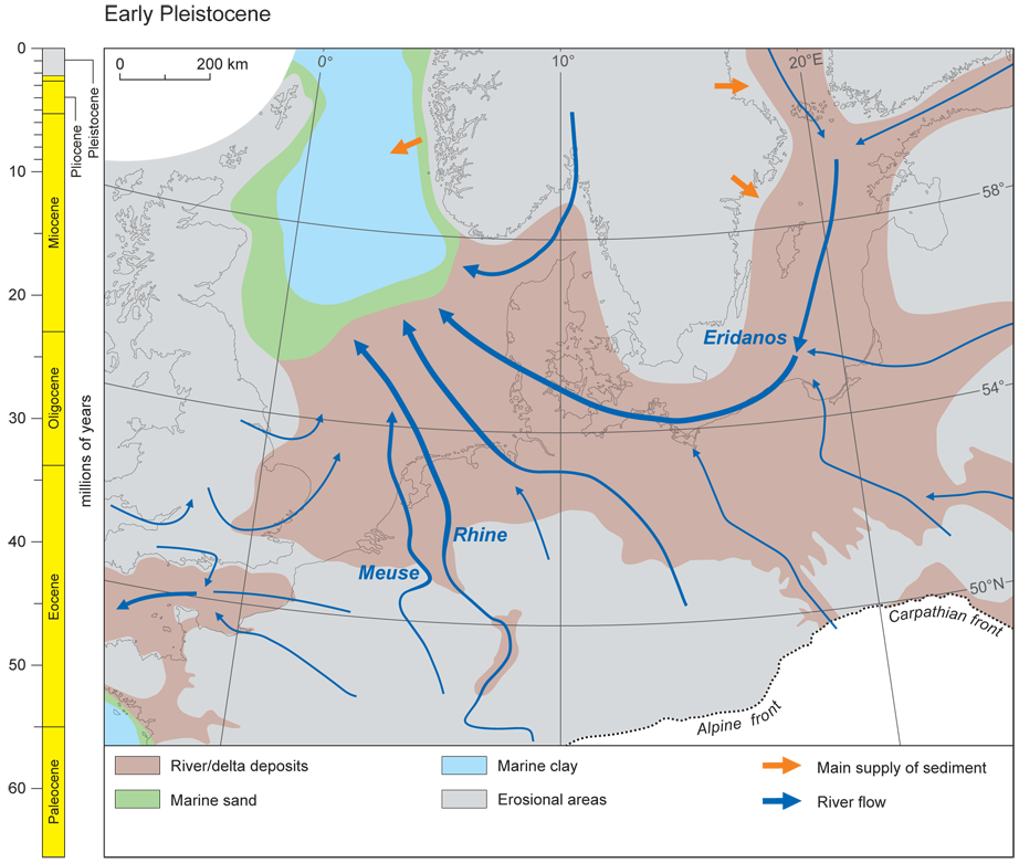
It was Eridanos river before the GlatiationAlso, Scandenvia. If it never Glaciated would the Baltic Sea be smaller lakes or just a river basin?.

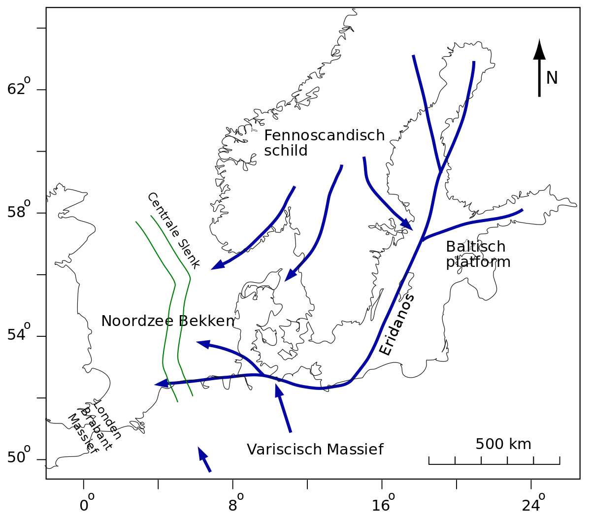
Eridanos (geology) - Wikipedia
What of the North Channel and/or the Irish Sea. Are either of them escavated by glaciers or are they naturally like that?.
Wikipedia says the Delta is probably as wide as the Amazon's.
So I did some digging into what that meant exactly and got this for the Delta/land cover just before Glaciation.
Looking to the small area to in Atlantic France it seems the sea level is close to today's which matches with Scotese's Neogene map that gives Plio-Pleistocene as between our sea level and 40 below.
Given my map is something between 33 and 36 metres, I think I should draw the coast around where it is on this map.
That makes sense right?.
Anyway, in the original Jaredia there's a giant Island in the Caspian-Aral. Which is an issue cuz the Caspian drains into the Black Sea and that into the Mediterranean before the sea level gets that high. Now, if the Caspian drained into the Ob river and that into the Arctic then that can be justified so, how do we block the Bosphorus up to the elevation of Istanbul?
1. The Glacier in Anatolia directly blocking the Bosphorus which I think is weak and dangerous for the TL, a slight warming and the compressed salty ice turns liquid from the bottom of the strait and I am not sure it would even freeze. On the other hand, it is helped along in that the Mediterranean is completely protected from warm currents from the world Ocean so would be extremely cold year around (like our Arctic) but I still have my doubts about marine permafrost, under pressure and in contact with the sea.
2. Some random crustal shananigens or erosion under the Anatolian Glacier when it was larger blocking the Dardanles and/or Bosphorus which I also think is weak cuz we don't need one basin to be eroded lower like in North America's extension of the mississippi but one basin't edge/trough to be higher and I don't know of a precidence for glacial crustal deformation or erosion to just pile up stability. Best I can think of here that is fairly stable and I can explain is the cycle of greater loading and unloading on the Crust causes by glaciers growing and shrinking induces some Neogene or Paleogene basaltic flow volcanism in Bithynia that floods over and closes the Bosphorus and associated low lands.
3. Final excuse I am thinking of, buying into the theory that catastrophic floods created the Bosphorus and no catastrophic floods in TTL. May be the weakest as water probs flowed through the Caspian into the Black Sea to the Mediterranean like up to 50,000 years ago before most of the catastrophic floods hypothesis so even if it wasn't 30ish metres down then, it was pretty down already.
Maybe a combination of all 3 are what I need. Anyways, all the above would mean that the Black Sea and Caspian would share the same water level, a water level that'll extend all the way to the lower Danube and even Hungarian plain. Something that I am not too fond of as it wouldn't look Jaredia.
Anyways, this would have the important feature that the Black Sea drains into the Caspian. That's the only way I can be sure it'll be that big. We can also have a similar effect by having the Gibraltar remain stuck, Ala Messinian Salinity crisis or just erosion from Africa and Spain. Because the Ice melt from Africa and Europe would certainly be enough to keep the basins filled.
Such would be the greatest timeline here, I think.
--
So, I was thinking of how to make it so that the through of the Black basin and Caspian Sea basins would be higher without glaciation. I once heard glaciation extended a bit into kyrgyzstan is that enough of an excuse? I don't think so again, because of the point that weakened my 3. excuse in the last part. But if it works, we could have different water levels between the Caspian(higher) and Black Sea(lower) and look more Jaredia. Hell, I won't need to explain away the bosphorus or dardanles which can remain same as OTL.
Or should I just accept the generally lower levels of the Caspian here? And just have have it drain into a similarly normal Black Sea to the Ocean?.
So what do you guys think I should go with for the Neo-Tethys lakes system?.
I think Volcanism or Glaciers are the most realistic way to block it, tho I guess erosion can also play a part. The Glaciers excuse especially as even if we decide not to go with it, during Ice ages, it certainly would block it and this would be an ice age map.
The version of things where it just drains into the Black Sea. Haven't decided the size of the Aral Sea here, yet tho. Anyways, the Sub-Antarctic Islands and the fjords of Illyria also done.
Next will be Middle America, Great Bear Lake and the Glacial lakes of Eurabia.
Also, you may have noticed the nice Doggerland, almost as big as you'ld expect in ice age. That's what a gigariver, almost Amazon levels sedimentation, Eridanos(or Amber) River gets you.Wikipedia says the Delta is probably as wide as the Amazon's.
So I did some digging into what that meant exactly and got this for the Delta/land cover just before Glaciation.
Looking to the small area to in Atlantic France it seems the sea level is close to today's which matches with Scotese's Neogene map that gives Plio-Pleistocene as between our sea level and 40 below.
Given my map is something between 33 and 36 metres, I think I should draw the coast around where it is on this map.
That makes sense right?.
Last edited:
Personally I think trying to justify the error is silly and you should just have the Caspian be lower.Anyway, in the original Jaredia there's a giant Island in the Caspian-Aral. Which is an issue cuz the Caspian drains into the Black Sea and that into the Mediterranean before the sea level gets that high. Now, if the Caspian drained into the Ob river and that into the Arctic then that can be justified so, how do we block the Bosphorus up to the elevation of Istanbul?
1. The Glacier in Anatolia directly blocking the Bosphorus which I think is weak and dangerous for the TL, a slight warming and the compressed salty ice turns liquid from the bottom of the strait and I am not sure it would even freeze. On the other hand, it is helped along in that the Mediterranean is completely protected from warm currents from the world Ocean so would be extremely cold year around (like our Arctic) but I still have my doubts about marine permafrost, under pressure and in contact with the sea.
2. Some random crustal shananigens or erosion under the Anatolian Glacier when it was larger blocking the Dardanles and/or Bosphorus which I also think is weak cuz we don't need one basin to be eroded lower like in North America's extension of the mississippi but one basin't edge/trough to be higher and I don't know of a precidence for glacial crustal deformation or erosion to just pile up stability. Best I can think of here that is fairly stable and I can explain is the cycle of greater loading and unloading on the Crust causes by glaciers growing and shrinking induces some Neogene or Paleogene basaltic flow volcanism in Bithynia that floods over and closes the Bosphorus and associated low lands.
3. Final excuse I am thinking of, buying into the theory that catastrophic floods created the Bosphorus and no catastrophic floods in TTL. May be the weakest as water probs flowed through the Caspian into the Black Sea to the Mediterranean like up to 50,000 years ago before most of the catastrophic floods hypothesis so even if it wasn't 30ish metres down then, it was pretty down already.
Maybe a combination of all 3 are what I need. Anyways, all the above would mean that the Black Sea and Caspian would share the same water level, a water level that'll extend all the way to the lower Danube and even Hungarian plain. Something that I am not too fond of as it wouldn't look Jaredia.
Anyways, this would have the important feature that the Black Sea drains into the Caspian. That's the only way I can be sure it'll be that big. We can also have a similar effect by having the Gibraltar remain stuck, Ala Messinian Salinity crisis or just erosion from Africa and Spain. Because the Ice melt from Africa and Europe would certainly be enough to keep the basins filled.
Such would be the greatest timeline here, I think.
--
So, I was thinking of how to make it so that the through of the Black basin and Caspian Sea basins would be higher without glaciation. I once heard glaciation extended a bit into kyrgyzstan is that enough of an excuse? I don't think so again, because of the point that weakened my 3. excuse in the last part. But if it works, we could have different water levels between the Caspian(higher) and Black Sea(lower) and look more Jaredia. Hell, I won't need to explain away the bosphorus or dardanles which can remain same as OTL.
Or should I just accept the generally lower levels of the Caspian here? And just have have it drain into a similarly normal Black Sea to the Ocean?.
So what do you guys think I should go with for the Neo-Tethys lakes system?.
Eh, at least I can still use it for Ice ages and we also get an even flatter Muscovy as a result.Personally I think trying to justify the error is silly and you should just have the Caspian be lower.
--
But aside from that, more Eurabia Glacial Lakes and a few Fjords. I feel like I over did it a bit so some criticisms on where I should reduce it. Also, still not done yet, so alot of places like Pontus and Hellas lack Fjords completely and I will still have to get to the Caribbean, Middle America, Orinoco and Guyanas later.
Okay, it seems Doggerland was formed by... the Greater Eridanos Delta so, we're basically just gonna get an Ice Age World for !Northern-Europe's Geography.Eh, at least I can still use it for Ice ages and we also get an even flatter Muscovy as a result.
--
But aside from that, more Eurabia Glacial Lakes and a few Fjords. I feel like I over did it a bit so some criticisms on where I should reduce it. Also, still not done yet, so alot of places like Pontus and Hellas lack Fjords completely and I will still have to get to the Caribbean, Middle America, Orinoco and Guyanas later.
View attachment 878195


From,
Morphology and pattern of Quaternary sedimentation in the North Sea Basin (52–62°N)
Anyways, At least I also found this one for how to make the river map for the North Sea and with so, so much sediment, that lake in the North Sea would be mostly or entirely, filled up.
The Rivers Map.
The New "Northern Europe" Map.
I wanted to do a small project on trying to predict what the emergence of civilisation would look like in retrograde earth. Please note that I am not an expert so everything here should be treated as educated guessing on my part. Also I am going to ignore the New World because I know nothing about it.
Neolithic:
Retrograde China strongly resembles the Prograde Middle East with its large rivers flowing through relatively dry regions, so it might develop along similiar lines. Under this assumption, wheat-based agriculture would emerge first in China in the Huanghe river plain at the beginning of the holocene, and a few thousand years later it has spread to most of east asia's watered lowlands. Western Afro-Eurasia is a bit more tentative, there is a huge unbroken belt of subtropical climate that extends from the Maghreb to northern India. The closest real-world parallel to the climate here seems to be southern China, which in Prograde Earth was the origin point of rice cultivation. So perhaps in this world the fertile crescent would give rise to an agricultural package resembling that of prograde subtropical eastern asia. Central Asia has a climate similar to prograde northern china, and it is well-endowed with rivers, which perhaps might mean that agriculture would emerge here as well.

Chalcolithic:
By around the 4th millennium BC, we might expect that agriculture has spread to northeast asia, paralleling the spread of agriculture from the middle east to europe. Side note, did you know that the Aleutians are at the same latitude as Ireland? Unfortunately mainland Alaska is punishingly cold, so it doesn't seem like agriculture will be able to spread from warm Kamchatka to the New World. Rice-based agriculture would probably spread relatively quickly across north africa and southwest asia. Parts of the southern coast of Europe actually have a similar warm subtropical climate, so we might expect that the people in the warm coastal valleys of southern Spain, southern Italy, and the Aegean would also adopt rice farming. However, most of southern europe has a relatively cold continental climate that would appear to be unsuitable for rice cultivation. Tabaristan and Afghanistan have a similar climate to central asia, so farming might also spread to those regions.
Around this time in prograde earth we saw the emergence of stratified urban societies in the fertile crescent, so we might expect that something similar would happen in China.

Early Bronze Age:
By this time, we might expect that agriculture would spread to most of southern europe and also begin spreading into equatorial africa and equatorial asia. Around this time early stratified societies emerged in East Asia (such as the later phase of the longshan culture), so we might expect western afro-eurasia to parallel this and develop complex societies in the deforested river plains of the middle east, central asia, and northeast india.

Late Bronze Age:
Something that stands out to me is that north africa in this world doesn't really have any exact parallel in prograde earth. It's a large region that will probably host complex agricultural societies early on in history, and it isn't partitioned by geography or climate into subsections. Large cultivated plains like this in our world (think Russia, northern India, and north China) tend to host empire cycles and promote cultural integration across their breadth. The green retrograde Sahara is significantly larger than any of those, but I still wonder if this region might host a very large empire spanning from Egypt to the Atlantic.
The lower and middle Yangtze plain might host a civilisation similar to prograde Egypt, with no major geographical barriers preventing the unification of the alluvial plain. The desert on its northern and southern borders will probably lack any significant rivers and therefore will be populated mostly by nomads. The Huanghe, Yangtze, and Sichuan societies in this world can be expected to experience intermittent conquest by the nomads to their south and north, much like the prograde middle east. Japan, Korea, Kamchatka, and northern Manchuria will probably be safe from most of these events due to their lack of steppe. The actual middle east (and India) might not experience many, if any, nomad conquests compared to our world since the arid climates on this side of afro-eurasia are limited to just central asia.
European civilisation will probably always remain strongly centred around the Mediterranean. If the Saharan empires I am postulating really exist, perhaps we might predict Europe to at various times fall under the political domination of North Africa.

Neolithic:
Retrograde China strongly resembles the Prograde Middle East with its large rivers flowing through relatively dry regions, so it might develop along similiar lines. Under this assumption, wheat-based agriculture would emerge first in China in the Huanghe river plain at the beginning of the holocene, and a few thousand years later it has spread to most of east asia's watered lowlands. Western Afro-Eurasia is a bit more tentative, there is a huge unbroken belt of subtropical climate that extends from the Maghreb to northern India. The closest real-world parallel to the climate here seems to be southern China, which in Prograde Earth was the origin point of rice cultivation. So perhaps in this world the fertile crescent would give rise to an agricultural package resembling that of prograde subtropical eastern asia. Central Asia has a climate similar to prograde northern china, and it is well-endowed with rivers, which perhaps might mean that agriculture would emerge here as well.
Chalcolithic:
By around the 4th millennium BC, we might expect that agriculture has spread to northeast asia, paralleling the spread of agriculture from the middle east to europe. Side note, did you know that the Aleutians are at the same latitude as Ireland? Unfortunately mainland Alaska is punishingly cold, so it doesn't seem like agriculture will be able to spread from warm Kamchatka to the New World. Rice-based agriculture would probably spread relatively quickly across north africa and southwest asia. Parts of the southern coast of Europe actually have a similar warm subtropical climate, so we might expect that the people in the warm coastal valleys of southern Spain, southern Italy, and the Aegean would also adopt rice farming. However, most of southern europe has a relatively cold continental climate that would appear to be unsuitable for rice cultivation. Tabaristan and Afghanistan have a similar climate to central asia, so farming might also spread to those regions.
Around this time in prograde earth we saw the emergence of stratified urban societies in the fertile crescent, so we might expect that something similar would happen in China.
Early Bronze Age:
By this time, we might expect that agriculture would spread to most of southern europe and also begin spreading into equatorial africa and equatorial asia. Around this time early stratified societies emerged in East Asia (such as the later phase of the longshan culture), so we might expect western afro-eurasia to parallel this and develop complex societies in the deforested river plains of the middle east, central asia, and northeast india.
Late Bronze Age:
Something that stands out to me is that north africa in this world doesn't really have any exact parallel in prograde earth. It's a large region that will probably host complex agricultural societies early on in history, and it isn't partitioned by geography or climate into subsections. Large cultivated plains like this in our world (think Russia, northern India, and north China) tend to host empire cycles and promote cultural integration across their breadth. The green retrograde Sahara is significantly larger than any of those, but I still wonder if this region might host a very large empire spanning from Egypt to the Atlantic.
The lower and middle Yangtze plain might host a civilisation similar to prograde Egypt, with no major geographical barriers preventing the unification of the alluvial plain. The desert on its northern and southern borders will probably lack any significant rivers and therefore will be populated mostly by nomads. The Huanghe, Yangtze, and Sichuan societies in this world can be expected to experience intermittent conquest by the nomads to their south and north, much like the prograde middle east. Japan, Korea, Kamchatka, and northern Manchuria will probably be safe from most of these events due to their lack of steppe. The actual middle east (and India) might not experience many, if any, nomad conquests compared to our world since the arid climates on this side of afro-eurasia are limited to just central asia.
European civilisation will probably always remain strongly centred around the Mediterranean. If the Saharan empires I am postulating really exist, perhaps we might predict Europe to at various times fall under the political domination of North Africa.
Last edited:
In the first two maps, yellow is wheat-based agriculture, turquoise is rice-based agriculture, purple is millet-based agriculture, dark blue is papuan agriculture, and grey-blue is stratified urban societies.@Linbot, What do the colors on the maps mean?
In the second two maps, green are unstratified farming societies, red are pastoralist societies, and grey-blue are stratified urban societies.
Quite a bit of North and South America is similar to the Middle-East and North Africa OTL. So while it's unlikely for agriculture to move to the New World, it would be likely that the humans there develop it independently. Or are you saying that it's the humans who couldn't spread to the New World due to the unfriendly environment of Alaska?Unfortunately mainland Alaska is punishingly cold, so it doesn't seem like agriculture will be able to spread from warm Kamchatka to the New World.
Share: