You are using an out of date browser. It may not display this or other websites correctly.
You should upgrade or use an alternative browser.
You should upgrade or use an alternative browser.
Of lost monkeys and broken vehicles
- Thread starter Lascaris
- Start date
Threadmarks
View all 218 threadmarks
Reader mode
Reader mode
Recent threadmarks
Part 169 Appendix Fate of world battleships September 1945 Interlude - Where are they now 1945 part I Interlude - Where are they now 1945 part II Interlude - Where are they now 1945 part III Appendix Hellenic Navy September 1945 Appendix Turkish Navy September 1945 Interlude - Where are they now 1945 part IVAs long she's not arrested for espionage and remains under the radar yes.I wonder how Savitri Devi fares ATL. Probably the same as OTL.
Last edited:
Thanks for the multiple maps first of all/
@Vaeius I just want to take a second to thank you for your constant map making when it comes to our discussions. I’ve no idea how to make maps and you blow me away with how frequently you throw maps out in the thread. That said I broadly agree with your thoughts on the map as well. Great job
Thank you! I have fun making them when the mood takes me! For this it kinda feels like there's a group of British and Greek diplomats sitting in my head drawing lines, with one guy drunk in corner pounding the table shouting: "Megali! Megali, Megali, Megali!" Being slowly calmed down and walked back as the thread goes on and I get a better understanding of the region and time-period.I concur with this sentiment (minus the self-deprecating humor about not having cartography skills because I know I do lol (no insult meant @Duke of Orlando <.<))
Speaking of, since it seems that people aren't tired of my many maps, let me throw out a few more proposals to the diplomats of the western allies based on a few points @Lascaris has raised...
You did mention that the Greeks had landed in Bodrum for 'political' reasons a couple chapters ago so the Greeks must want something in Caria at least. So logically if they're going for Halicarnassus it would make sense to connect it with the rest of Asiatic Greece and establish a reasonably defensible border around such annexations and extend around defensible terrain. Rather than just grabbing an indefensible enclave?Short off. Again it's nearly 80% Turkish. Even when counted together with the Dodecanese, which is not in the Greeks interest to claim, it still has a solid Turkish majority. Soo what are the Greeks gaining from claiming the whole lot? Security for the islands at the cost of extending their land frontier? Historical/nationalist goals like controlling Bodrum? Now mind you controlling parts of territory may be more practical.
Most of the regions I highlighted (outside of the dark blue areas anyway) are rather mountainous, hilly, or heavily forested even in the modern day. I'd imagine they'd be even more sparsely populated 80-90 years ago. Taking some/any of it would add at least a bit of strategic depth against a country that has attacked them three times now in almost as many decades. After all, Greece here doesn't know that NATO will come around and stay around, they don't know about the Manhattan project and MAD doctrine doesn't exist yet. In my mind it'd be worth pushing that border south and east instead of counting on the US not to go into isolation again.I don't see the Greeks asking for territory just for territory's shake. There must be a reason, military or population wise. The Greek demands i the 1919 peace conference may offer a logical starting point here.
(I'm American and still kinda annoyed we didn't join the LON.)
From what I understand, Greece has already achieved... all of it's goals from 1919? Northern Epirus, Thrace, the Smyrna district... what are they missing? Besides Constantinople obviously.
I will point out, that regardless of the human cost, the allies (even the western allies) weren't exactly shy about rearranging the borders after the war. France even got some border adjustments off of Italy, which is what I'm kinda justifying the smaller border adjustments with Bulgaria and Albania on, France has been attacked by Italy much less than Greece has been attacked by Bulgaria after all.
As for areas of annexations...
To get back into this, just some numbers. Areas that can potentially be claimed by Greece and their TTL pre-war population.
Territory Land area km2 Turkish population Non-Turkish population Cannakkale 8,329 182,547 49,086 (42,105 Greek) Balikesir 4,530 126,687 0 Bursa west-south of Olympus/Uludag 5,444 105,288 0 Simav-Saphane 1,961 44,037 0 Usak plateau (Buldan-Esme- Usak-Banaz) 6,680 157,415 0 Cal-Civril-Baklan 3,017 74,962 Sokia/Soke (includes Kusadasi, Didim) 1,545 20,716 Aydin south of Meander/Menderes 4,515 144,656 Halikarnassos/Bodrum +Milas/Miletos 2,766 63,404 Marmaris-Datka peninsula 1,354 14,184 Rest of Mugla province 8,534 133,857
According to these numbers, expansion in the south from areas with any Greeks would mean somewhere around 300,000ish people being displaced depending on how the line is drawn and if the Greek government goes ahead with expulsion of whoever didn't already flee. Compared to the German numbers of 12-14.6 million displaced I don't think that's an exceptionally high number at the expense of of a country that has fought the allies through two world wars and fought the Greeks in the Balkan wars before that.
Albeit I'm not counting... whatever the Soviets might do with whatever they might annex.
But can the foreign office tell the colonial office to pound sand yet? Churchill was in favor of giving it to Greece if I remember right wasn't he? But he lost the 1945 election iotl...There was quite a bit of support in the British foreign office for giving Cyprus to Greece at the time actually. The British TTL have to be giving something to Cyprus TTL even if it's just more extensive self-government, as noted before Cyprus still has uninterrupted elections and a legislative assembly TTL which is a big difference from OTL.
Regardless, below are a few possibilities! In all of them, I expanded Kurdistan based on:
The Kurds at the moment are too strong to accept anything less than a unitary Kurdish state covering everything outside Iranian Kurdistan. So the question is more how the Hashemites and Assyrians deal with that and each other. Which ultimately ends to whether Abdullah makes a deal accepting the loss of Iraqi Kurdistan or sends the Legion north to contest that. He might well do either I'd think.
Also weren't the Assyrians the primary reason that Mosul ended up as part of Iraq in the first place? Full circle! A smaller 'Assyria' remains in blue even if I think they'll likely remain as part of Iraq in some capacity, at least for a while. Soviet Georgia's expansion is also a little bit lessened but I really don't know what could happen there. Although If they reached Trebizond are they inclined to leave?
I also returned the rest of Cannakale to the international mandate to spare the Soviet's feelings.
Map A:
'Minimalist Greece'- The only notable expansion is to include the Northern part of former Italian Caria and the Dodeccanese. Otherwise no changes at all to the Greek border. It's also the one I like the least considering that abomination of a border with Albania. Includes a land connection to Halicarnassus.
Map B:
'Minor Gains Greece'
Same partial annexation of Caria, plus slight border adjustments in Albania and Bulgaria- Mountains, forests, and hills. The biggest change here is a slight expansion of Greece's 'panhandle' based on some discussion I saw about the Pomaks. Only a slight change to the border in Northern Asiatic Greece. The Albanian border looks better.
Map C:
'Worth giving up the city, Greece'
Includes the 'most' territorial gains of the three, but still less than the maximum of my claims map. Includes the whole Caria mandate as well as slightly more expansion in northern Asiatic Greece. Including Myra/Demre-Saint Nick can come home from his Italian vacation. This would also allow Turkish waters to be rather restricted if one throws Cyprus into the considerations.
It does exclude the Turkish population centers in Denizili as well (from what I can tell anyway, Google maps is a bit difficult to line up...).
It's also my favorite of the three.
....This post kinda ballooned again. Sorry about that.
Aha l did not notice Karabekir fell for it and became PM.
He is not really renowned for his political acumen.
And on that note, the Arrow Cross Party and the Government of National Unity could make a good equivalent to any Iron Guard regime the Germans could install if the events in Turkey lead to the Nazis keeping a closer eye on their minor allies and any disloyalty they have.Then many rabid nationalists around Europe ended as collaborators putting the supposed Soviet threat first so I'd be hardly surprised.
I like map A the most because means more stable territory with proportionally more greeks and less expelled Turks.Thank you! I have fun making them when the mood takes me! For this it kinda feels like there's a group of British and Greek diplomats sitting in my head drawing lines, with one guy drunk in corner pounding the table shouting: "Megali! Megali, Megali, Megali!" Being slowly calmed down and walked back as the thread goes on and I get a better understanding of the region and time-period.
Speaking of, since it seems that people aren't tired of my many maps, let me throw out a few more proposals to the diplomats of the western allies based on a few points @Lascaris has raised...
You did mention that the Greeks had landed in Bodrum for 'political' reasons a couple chapters ago so the Greeks must want something in Caria at least. So logically if they're going for Halicarnassus it would make sense to connect it with the rest of Asiatic Greece and establish a reasonably defensible border around such annexations and extend around defensible terrain. Rather than just grabbing an indefensible enclave?
Most of the regions I highlighted (outside of the dark blue areas anyway) are rather mountainous, hilly, or heavily forested even in the modern day. I'd imagine they'd be even more sparsely populated 80-90 years ago. Taking some/any of it would add at least a bit of strategic depth against a country that has attacked them three times now in almost as many decades. After all, Greece here doesn't know that NATO will come around and stay around, they don't know about the Manhattan project and MAD doctrine doesn't exist yet. In my mind it'd be worth pushing that border south and east instead of counting on the US not to go into isolation again.
(I'm American and still kinda annoyed we didn't join the LON.)
From what I understand, Greece has already achieved... all of it's goals from 1919? Northern Epirus, Thrace, the Smyrna district... what are they missing? Besides Constantinople obviously.
I will point out, that regardless of the human cost, the allies (even the western allies) weren't exactly shy about rearranging the borders after the war. France even got some border adjustments off of Italy, which is what I'm kinda justifying the smaller border adjustments with Bulgaria and Albania on, France has been attacked by Italy much less than Greece has been attacked by Bulgaria after all.
As for areas of annexations...
According to these numbers, expansion in the south from areas with any Greeks would mean somewhere around 300,000ish people being displaced depending on how the line is drawn and if the Greek government goes ahead with expulsion of whoever didn't already flee. Compared to the German numbers of 12-14.6 million displaced I don't think that's an exceptionally high number at the expense of of a country that has fought the allies through two world wars and fought the Greeks in the Balkan wars before that.
Albeit I'm not counting... whatever the Soviets might do with whatever they might annex.
But can the foreign office tell the colonial office to pound sand yet? Churchill was in favor of giving it to Greece if I remember right wasn't he? But he lost the 1945 election iotl...
Regardless, below are a few possibilities! In all of them, I expanded Kurdistan based on:
Also weren't the Assyrians the primary reason that Mosul ended up as part of Iraq in the first place? Full circle! A smaller 'Assyria' remains in blue even if I think they'll likely remain as part of Iraq in some capacity, at least for a while. Soviet Georgia's expansion is also a little bit lessened but I really don't know what could happen there. Although If they reached Trebizond are they inclined to leave?
I also returned the rest of Cannakale to the international mandate to spare the Soviet's feelings.
Map A:
View attachment 856919
'Minimalist Greece'- The only notable expansion is to include the Northern part of former Italian Caria and the Dodeccanese. Otherwise no changes at all to the Greek border. It's also the one I like the least considering that abomination of a border with Albania. Includes a land connection to Halicarnassus.
Map B:
View attachment 856922
'Minor Gains Greece'
Same partial annexation of Caria, plus slight border adjustments in Albania and Bulgaria- Mountains, forests, and hills. The biggest change here is a slight expansion of Greece's 'panhandle' based on some discussion I saw about the Pomaks. Only a slight change to the border in Northern Asiatic Greece. The Albanian border looks better.
Map C:
View attachment 856926
'Worth giving up the city, Greece'
Includes the 'most' territorial gains of the three, but still less than the maximum of my claims map. Includes the whole Caria mandate as well as slightly more expansion in northern Asiatic Greece. Including Myra/Demre-Saint Nick can come home from his Italian vacation. This would also allow Turkish waters to be rather restricted if one throws Cyprus into the considerations.
It does exclude the Turkish population centers in Denizili as well (from what I can tell anyway, Google maps is a bit difficult to line up...).
It's also my favorite of the three.
....This post kinda ballooned again. Sorry about that.
Tbf I could see them taking more from Bulgaria but otherwise yeah I think it works.Map C:
Tbf considering how much Germans got ethnically cleansed unless the Greeks annex anything from the Marmara region it wouldn't be that serious.I like map A the most because means more stable territory with proportionally more greeks and less expelled Turks.
Map B but add Cyprus and that's what I think would make aesthetic sense (otherwise I'd go with that + Constantinople and - Cyprus for legit political reasons)..... if it was my choice to decide I mean P;Thank you! I have fun making them when the mood takes me! For this it kinda feels like there's a group of British and Greek diplomats sitting in my head drawing lines, with one guy drunk in corner pounding the table shouting: "Megali! Megali, Megali, Megali!" Being slowly calmed down and walked back as the thread goes on and I get a better understanding of the region and time-period.
Speaking of, since it seems that people aren't tired of my many maps, let me throw out a few more proposals to the diplomats of the western allies based on a few points @Lascaris has raised...
You did mention that the Greeks had landed in Bodrum for 'political' reasons a couple chapters ago so the Greeks must want something in Caria at least. So logically if they're going for Halicarnassus it would make sense to connect it with the rest of Asiatic Greece and establish a reasonably defensible border around such annexations and extend around defensible terrain. Rather than just grabbing an indefensible enclave?
Most of the regions I highlighted (outside of the dark blue areas anyway) are rather mountainous, hilly, or heavily forested even in the modern day. I'd imagine they'd be even more sparsely populated 80-90 years ago. Taking some/any of it would add at least a bit of strategic depth against a country that has attacked them three times now in almost as many decades. After all, Greece here doesn't know that NATO will come around and stay around, they don't know about the Manhattan project and MAD doctrine doesn't exist yet. In my mind it'd be worth pushing that border south and east instead of counting on the US not to go into isolation again.
(I'm American and still kinda annoyed we didn't join the LON.)
From what I understand, Greece has already achieved... all of it's goals from 1919? Northern Epirus, Thrace, the Smyrna district... what are they missing? Besides Constantinople obviously.
I will point out, that regardless of the human cost, the allies (even the western allies) weren't exactly shy about rearranging the borders after the war. France even got some border adjustments off of Italy, which is what I'm kinda justifying the smaller border adjustments with Bulgaria and Albania on, France has been attacked by Italy much less than Greece has been attacked by Bulgaria after all.
As for areas of annexations...
According to these numbers, expansion in the south from areas with any Greeks would mean somewhere around 300,000ish people being displaced depending on how the line is drawn and if the Greek government goes ahead with expulsion of whoever didn't already flee. Compared to the German numbers of 12-14.6 million displaced I don't think that's an exceptionally high number at the expense of of a country that has fought the allies through two world wars and fought the Greeks in the Balkan wars before that.
Albeit I'm not counting... whatever the Soviets might do with whatever they might annex.
But can the foreign office tell the colonial office to pound sand yet? Churchill was in favor of giving it to Greece if I remember right wasn't he? But he lost the 1945 election iotl...
Regardless, below are a few possibilities! In all of them, I expanded Kurdistan based on:
Also weren't the Assyrians the primary reason that Mosul ended up as part of Iraq in the first place? Full circle! A smaller 'Assyria' remains in blue even if I think they'll likely remain as part of Iraq in some capacity, at least for a while. Soviet Georgia's expansion is also a little bit lessened but I really don't know what could happen there. Although If they reached Trebizond are they inclined to leave?
I also returned the rest of Cannakale to the international mandate to spare the Soviet's feelings.
Map A:
View attachment 856919
'Minimalist Greece'- The only notable expansion is to include the Northern part of former Italian Caria and the Dodeccanese. Otherwise no changes at all to the Greek border. It's also the one I like the least considering that abomination of a border with Albania. Includes a land connection to Halicarnassus.
Map B:
View attachment 856922
'Minor Gains Greece'
Same partial annexation of Caria, plus slight border adjustments in Albania and Bulgaria- Mountains, forests, and hills. The biggest change here is a slight expansion of Greece's 'panhandle' based on some discussion I saw about the Pomaks. Only a slight change to the border in Northern Asiatic Greece. The Albanian border looks better.
Map C:
View attachment 856926
'Worth giving up the city, Greece'
Includes the 'most' territorial gains of the three, but still less than the maximum of my claims map. Includes the whole Caria mandate as well as slightly more expansion in northern Asiatic Greece. Including Myra/Demre-Saint Nick can come home from his Italian vacation. This would also allow Turkish waters to be rather restricted if one throws Cyprus into the considerations.
It does exclude the Turkish population centers in Denizili as well (from what I can tell anyway, Google maps is a bit difficult to line up...).
It's also my favorite of the three.
....This post kinda ballooned again. Sorry about that.
Last edited:
What's the status of Marmara Island and Prince's Islands here? (latter is light blue I assume)Thank you! I have fun making them when the mood takes me! For this it kinda feels like there's a group of British and Greek diplomats sitting in my head drawing lines, with one guy drunk in corner pounding the table shouting: "Megali! Megali, Megali, Megali!" Being slowly calmed down and walked back as the thread goes on and I get a better understanding of the region and time-period.
Speaking of, since it seems that people aren't tired of my many maps, let me throw out a few more proposals to the diplomats of the western allies based on a few points @Lascaris has raised...
You did mention that the Greeks had landed in Bodrum for 'political' reasons a couple chapters ago so the Greeks must want something in Caria at least. So logically if they're going for Halicarnassus it would make sense to connect it with the rest of Asiatic Greece and establish a reasonably defensible border around such annexations and extend around defensible terrain. Rather than just grabbing an indefensible enclave?
Most of the regions I highlighted (outside of the dark blue areas anyway) are rather mountainous, hilly, or heavily forested even in the modern day. I'd imagine they'd be even more sparsely populated 80-90 years ago. Taking some/any of it would add at least a bit of strategic depth against a country that has attacked them three times now in almost as many decades. After all, Greece here doesn't know that NATO will come around and stay around, they don't know about the Manhattan project and MAD doctrine doesn't exist yet. In my mind it'd be worth pushing that border south and east instead of counting on the US not to go into isolation again.
(I'm American and still kinda annoyed we didn't join the LON.)
From what I understand, Greece has already achieved... all of it's goals from 1919? Northern Epirus, Thrace, the Smyrna district... what are they missing? Besides Constantinople obviously.
I will point out, that regardless of the human cost, the allies (even the western allies) weren't exactly shy about rearranging the borders after the war. France even got some border adjustments off of Italy, which is what I'm kinda justifying the smaller border adjustments with Bulgaria and Albania on, France has been attacked by Italy much less than Greece has been attacked by Bulgaria after all.
As for areas of annexations...
According to these numbers, expansion in the south from areas with any Greeks would mean somewhere around 300,000ish people being displaced depending on how the line is drawn and if the Greek government goes ahead with expulsion of whoever didn't already flee. Compared to the German numbers of 12-14.6 million displaced I don't think that's an exceptionally high number at the expense of of a country that has fought the allies through two world wars and fought the Greeks in the Balkan wars before that.
Albeit I'm not counting... whatever the Soviets might do with whatever they might annex.
But can the foreign office tell the colonial office to pound sand yet? Churchill was in favor of giving it to Greece if I remember right wasn't he? But he lost the 1945 election iotl...
Regardless, below are a few possibilities! In all of them, I expanded Kurdistan based on:
Also weren't the Assyrians the primary reason that Mosul ended up as part of Iraq in the first place? Full circle! A smaller 'Assyria' remains in blue even if I think they'll likely remain as part of Iraq in some capacity, at least for a while. Soviet Georgia's expansion is also a little bit lessened but I really don't know what could happen there. Although If they reached Trebizond are they inclined to leave?
I also returned the rest of Cannakale to the international mandate to spare the Soviet's feelings.
Map A:
View attachment 856919
'Minimalist Greece'- The only notable expansion is to include the Northern part of former Italian Caria and the Dodeccanese. Otherwise no changes at all to the Greek border. It's also the one I like the least considering that abomination of a border with Albania. Includes a land connection to Halicarnassus.
Map B:
View attachment 856922
'Minor Gains Greece'
Same partial annexation of Caria, plus slight border adjustments in Albania and Bulgaria- Mountains, forests, and hills. The biggest change here is a slight expansion of Greece's 'panhandle' based on some discussion I saw about the Pomaks. Only a slight change to the border in Northern Asiatic Greece. The Albanian border looks better.
Map C:
View attachment 856926
'Worth giving up the city, Greece'
Includes the 'most' territorial gains of the three, but still less than the maximum of my claims map. Includes the whole Caria mandate as well as slightly more expansion in northern Asiatic Greece. Including Myra/Demre-Saint Nick can come home from his Italian vacation. This would also allow Turkish waters to be rather restricted if one throws Cyprus into the considerations.
It does exclude the Turkish population centers in Denizili as well (from what I can tell anyway, Google maps is a bit difficult to line up...).
It's also my favorite of the three.
....This post kinda ballooned again. Sorry about that.
Map B is my favourite, with the addition that Cyprus gets increased autonomy and that in 5-10 years it can join Greece, with the British retaining a large base in Akrotiri (but not in Dhekelia) .Map A:

'Minimalist Greece'- The only notable expansion is to include the Northern part of former Italian Caria and the Dodeccanese. Otherwise no changes at all to the Greek border. It's also the one I like the least considering that abomination of a border with Albania. Includes a land connection to Halicarnassus.
Map B:

'Minor Gains Greece'
Same partial annexation of Caria, plus slight border adjustments in Albania and Bulgaria- Mountains, forests, and hills. The biggest change here is a slight expansion of Greece's 'panhandle' based on some discussion I saw about the Pomaks. Only a slight change to the border in Northern Asiatic Greece. The Albanian border looks better.
Map C:

'Worth giving up the city, Greece'
Includes the 'most' territorial gains of the three, but still less than the maximum of my claims map. Includes the whole Caria mandate as well as slightly more expansion in northern Asiatic Greece. Including Myra/Demre-Saint Nick can come home from his Italian vacation. This would also allow Turkish waters to be rather restricted if one throws Cyprus into the considerations.
It does exclude the Turkish population centers in Denizili as well (from what I can tell anyway, Google maps is a bit difficult to line up...).
Thank you! I have fun making them when the mood takes me! For this it kinda feels like there's a group of British and Greek diplomats sitting in my head drawing lines, with one guy drunk in corner pounding the table shouting: "Megali! Megali, Megali, Megali!" Being slowly calmed down and walked back as the thread goes on and I get a better understanding of the region and time-period.
Speaking of, since it seems that people aren't tired of my many maps, let me throw out a few more proposals to the diplomats of the western allies based on a few points @Lascaris has raised...
You did mention that the Greeks had landed in Bodrum for 'political' reasons a couple chapters ago so the Greeks must want something in Caria at least. So logically if they're going for Halicarnassus it would make sense to connect it with the rest of Asiatic Greece and establish a reasonably defensible border around such annexations and extend around defensible terrain. Rather than just grabbing an indefensible enclave?
Most of the regions I highlighted (outside of the dark blue areas anyway) are rather mountainous, hilly, or heavily forested even in the modern day. I'd imagine they'd be even more sparsely populated 80-90 years ago. Taking some/any of it would add at least a bit of strategic depth against a country that has attacked them three times now in almost as many decades. After all, Greece here doesn't know that NATO will come around and stay around, they don't know about the Manhattan project and MAD doctrine doesn't exist yet. In my mind it'd be worth pushing that border south and east instead of counting on the US not to go into isolation again.
(I'm American and still kinda annoyed we didn't join the LON.)
From what I understand, Greece has already achieved... all of it's goals from 1919? Northern Epirus, Thrace, the Smyrna district... what are they missing? Besides Constantinople obviously.
I will point out, that regardless of the human cost, the allies (even the western allies) weren't exactly shy about rearranging the borders after the war. France even got some border adjustments off of Italy, which is what I'm kinda justifying the smaller border adjustments with Bulgaria and Albania on, France has been attacked by Italy much less than Greece has been attacked by Bulgaria after all.
As for areas of annexations...
According to these numbers, expansion in the south from areas with any Greeks would mean somewhere around 300,000ish people being displaced depending on how the line is drawn and if the Greek government goes ahead with expulsion of whoever didn't already flee. Compared to the German numbers of 12-14.6 million displaced I don't think that's an exceptionally high number at the expense of of a country that has fought the allies through two world wars and fought the Greeks in the Balkan wars before that.
Albeit I'm not counting... whatever the Soviets might do with whatever they might annex.
But can the foreign office tell the colonial office to pound sand yet? Churchill was in favor of giving it to Greece if I remember right wasn't he? But he lost the 1945 election iotl...
Regardless, below are a few possibilities! In all of them, I expanded Kurdistan based on:
Also weren't the Assyrians the primary reason that Mosul ended up as part of Iraq in the first place? Full circle! A smaller 'Assyria' remains in blue even if I think they'll likely remain as part of Iraq in some capacity, at least for a while. Soviet Georgia's expansion is also a little bit lessened but I really don't know what could happen there. Although If they reached Trebizond are they inclined to leave?
I also returned the rest of Cannakale to the international mandate to spare the Soviet's feelings.
Map A:
View attachment 856919
'Minimalist Greece'- The only notable expansion is to include the Northern part of former Italian Caria and the Dodeccanese. Otherwise no changes at all to the Greek border. It's also the one I like the least considering that abomination of a border with Albania. Includes a land connection to Halicarnassus.
Map B:
View attachment 856922
'Minor Gains Greece'
Same partial annexation of Caria, plus slight border adjustments in Albania and Bulgaria- Mountains, forests, and hills. The biggest change here is a slight expansion of Greece's 'panhandle' based on some discussion I saw about the Pomaks. Only a slight change to the border in Northern Asiatic Greece. The Albanian border looks better.
Map C:
View attachment 856926
'Worth giving up the city, Greece'
Includes the 'most' territorial gains of the three, but still less than the maximum of my claims map. Includes the whole Caria mandate as well as slightly more expansion in northern Asiatic Greece. Including Myra/Demre-Saint Nick can come home from his Italian vacation. This would also allow Turkish waters to be rather restricted if one throws Cyprus into the considerations.
It does exclude the Turkish population centers in Denizili as well (from what I can tell anyway, Google maps is a bit difficult to line up...).
It's also my favorite of the three.
....This post kinda ballooned again. Sorry about that.
First of all is that really the current Greco-Albanian border ITTL? I was gonna eat breakfast but after seeing that choice piece of border gore I’m sick to my stomach lmao. So yeah I definitely appreciate what you did there.
Of your three maps (all of which I really appreciate by the way), C seems the most balanced between the Greek desire for culturally important areas with preexisting greek populations and the general desire to not conduct large scale ethnic cleansing on the Turks. Even if those Greek populations are small. That being said I think the Greeks are likely to try something like the map in your last post. Possibly something that has even a bit more land inland in central Anatolia to try and get a more defensible border. Not that they’ll necessarily get it. But I could definitely see them pushing for it.
I do agree that I find it unlikely that the Soviets would leave once they get somewhere, at least based of their behavior in OTL. I think they’ll inevitably be disappointed about Canakkale though. They may get a lot but nobody gets everything they want in a peace deal. They may get a base in the area but I do think the majority of the area inevitably ends up in Greek hands.
As for your Bulgarian border, it looks great but it might be messier (and possibly bigger) in reality. Since I don’t know of any religious demographic maps for the 1940’s, earlier maps are often highly biased, and the Soviets didn’t make such things for obvious reasons I feel like modern maps plus the two Pomak Republics might be our best bet to figure out what areas are majority Pomak. For easy reference I’ll link a Wikipedia map of each.

File:Bulgaria religous map by municipalities.png - Wikimedia Commons
File:Tamrashka republika en.png - Wikimedia Commons
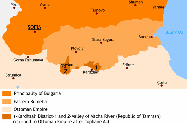
While you do get a lot of the Southern Pomaks you also leave some out, particularly those based around the old Republic of Tamash. Sure it sticks out in a not aesthetically pleasing way but I feel like it would absolutely be part of any attempt by Greece to claim the Pomaks as their own. That irreligious area is also probably at least partially Pomak in the 40’s since it was before they were targeted by the Soviets. I love the maps again but I figured I’d give you something to think about.
Edit: Spelling
Last edited:
I still do not think Kurdistan will extend too much veyond the fertile lowlands. Which raises a big question about its future as land reform will be a big issue, and will be the basis of the foundation of a ATL pro Soviet PKK.
Would seem that TTL the Greek Thrace would be roughly have the same extension than OTL... So, Adrianople/Edirne will be located inside of ITTL Greek Thrace? Or it still would remain out of the new border?
Probably Chakmak ordered him to take the poison chaliceHe is not really renowned for his political acumen.
I think they were already in Greece.Would seem that TTL the Greek Thrace would be roughly have the same extension than OTL... So, Adrianople/Edirne will be located inside of ITTL Greek Thrace? Or it still would remain out of the new border?
From Lascaris' map Marmara Island is already Greek and the Princes' Islands are too small to be mapped here, but I assume they'd be part of the mandate.What's the status of Marmara Island and Prince's Islands here? (latter is light blue I assume)
I had tweaked the border line at some point but yes.First of all is that really the current Greco-Albanian border ITTL? I was gonna eat breakfast but after seeing that choice piece of border gore I’m sick to my stomach lmao. So yeah I definitely appreciate what you did there.
C is definitely the one I like the most, though even there I tried to scale it back from the full extent of the claims map from the most densely populated areas.Of your three maps (all of which I really appreciate by the way), C seems the most balanced between the Greek desire for culturally important areas with preexisting greek populations and the general desire to not conduct large scale ethnic cleansing on the Turks. Even if those Greek populations are small. That being said I think the Greeks are likely to try something like the map in your last post. Possibly something that has even a bit more land inland in central Anatolia to try and get a more defensible border. Not that they’ll necessarily get it. But I could definitely see them pushing for it.
This was the post-ww1 map that Lascaris had provided way back in part 16.Would seem that TTL the Greek Thrace would be roughly have the same extension than OTL... So, Adrianople/Edirne will be located inside of ITTL Greek Thrace? Or it still would remain out of the new border?
Compared to the treaty of Sevres Greece had actually walked away with quite a bit more in Asia minor than they were initially promised. Which is also what I aligned a lot of the new borders on.The Near East after the end of World War 1, March 1922

While I didn't mention it in my main post, part of what I'm basing Greek expansion on are what I understand were OTL Greek border claims in southern Albania and border adjustments from Bulgaria, just scaled up to reflect what Greece already has, and the fact that they're both an unoccupied allied power and have much more sway than they did otl.
I will also point out that the Netherlands tried in otl to claim vast swaths of northern Germany with intent to give all the locals the boot. It failed because there were already waaaay to many refugees in the British and American occupation zones from the eastern annexations to handle more mass expulsions, that they would have to deal with and provide for. Plus the beginnings of a desire for some sort of west-Germany in the cold-war. Which is not the case with Turkey for a few reasons, not least because the allies wouldn't have to foot the bill for them.
I just think that if the Dutch were willing to push for this. Then an ascendant unoccupied Greece would very well claim a great deal, and get a good amount from the allies in exchange for letting Constantinople go. Which they did try to annex when the war kicked off.
Last edited:
Serpent
Banned
Would seem that TTL the Greek Thrace would be roughly have the same extension than OTL... So, Adrianople/Edirne will be located inside of ITTL Greek Thrace? Or it still would remain out of the new border?
Eastern Thrace has been a Greek territory since 1920... since the signing of the treaty of Sevres...
Been some years since reading Ihrig, but arguably yes. The German nationalist press was all over the Turkish nationalist movement from very early on, when it was losing arguing fighting and losing was preferable to not fighting. Post that yes Turkey did not win outright in 1919-21 TTL but secured several important concessions, and removed foreign influence within the country, while destroying Armenia in the east and stopping any idea of Kurdish independence.Would he have that to the same degree in this timeline where the Turkish Nationalist Movement failed to achieve (at least partially) its goals?
That's an effect of Tehran. The Greeks believe that they don't have any chance to get any territory they don't actually occupy at the time of the armistice. Thus are grabbing the territory in the coast that they had actually demanded in 1919. They may or may not be correct in this, but post Tehrean and Roosevelt and Churchill's visit in Athens there are... lets say way less trusting than they would have been otherwise.You did mention that the Greeks had landed in Bodrum for 'political' reasons a couple chapters ago so the Greeks must want something in Caria at least. So logically if they're going for Halicarnassus it would make sense to connect it with the rest of Asiatic Greece and establish a reasonably defensible border around such annexations and extend around defensible terrain. Rather than just grabbing an indefensible enclave?
A lot of them for certain. Improving the border after the experiences of 1941 is of course desirable but it is not that aside of Constantinople, the Dodecanese and Cyprus there are any great bodies of Greek population beyond Athens control.From what I understand, Greece has already achieved... all of it's goals from 1919? Northern Epirus, Thrace, the Smyrna district... what are they missing? Besides Constantinople obviously.
No border adjustments with Albania. Besides perhaps Sazan island. With Bulgaria the Americans were not supportive of border adjustments OTL. It remains to be seen TTL.I will point out, that regardless of the human cost, the allies (even the western allies) weren't exactly shy about rearranging the borders after the war. France even got some border adjustments off of Italy, which is what I'm kinda justifying the smaller border adjustments with Bulgaria and Albania on, France has been attacked by Italy much less than Greece has been attacked by Bulgaria after all.
That depends. Frex in OTL the Colonial office was using the Greek civil war as an excuse. TTL its no big spoiler to say a Greek civil war is entirely unlikely.But can the foreign office tell the colonial office to pound sand yet? Churchill was in favor of giving it to Greece if I remember right wasn't he? But he lost the 1945 election iotl...
The bad question for the Assyrians is if Abdullah is forced to accept the loss of Iraqi Kurdistan... can he afford any concessions at all to the Assyrians? Who are hated by his new Iraqi subjects, hence any concessions would be affecting his hold on the throne?Regardless, below are a few possibilities! In all of them, I expanded Kurdistan based on:
Also weren't the Assyrians the primary reason that Mosul ended up as part of Iraq in the first place? Full circle! A smaller 'Assyria' remains in blue even if I think they'll likely remain as part of Iraq in some capacity, at least for a while.
The Turkish population affected might uhm... disagree?Tbf considering how much Germans got ethnically cleansed unless the Greeks annex anything from the Marmara region it wouldn't be that serious.
The former is Greek territory since 1921. The latter would be part of Constantinople. And given being 94% Greek would likely fall with the Western zone.What's the status of Marmara Island and Prince's Islands here? (latter is light blue I assume)
the maps out of necessity use modern Albanian districts. Of which to copy from my raw notes, North Epirus is the followingFirst of all is that really the current Greco-Albanian border ITTL? I was gonna eat breakfast but after seeing that choice piece of border gore I’m sick to my stomach lmao. So yeah I definitely appreciate what you did there.
| North Epirus | km2 |
| Devoli | 453 |
| Kolonia | 846 |
| Korytsa | 1752 |
| Argyrokastro | 1137 |
| Delvine | 348 |
| Saranta | 749 |
| Himara | 572 |
The ---- line on this map (second from north) is pretty close to the actual border it is what France and Britain were proposing in 1920. Although I almost went with the third which was the American proposals.
A bit or more than a bit would depend on what Greek populations you get outside Greece or Western zones as well about you'd see Circassians and some Pontic Muslims including in a potential population exchange.Of your three maps (all of which I really appreciate by the way), C seems the most balanced between the Greek desire for culturally important areas with preexisting greek populations and the general desire to not conduct large scale ethnic cleansing on the Turks. Even if those Greek populations are small. That being said I think the Greeks are likely to try something like the map in your last post. Possibly something that has even a bit more land inland in central Anatolia to try and get a more defensible border. Not that they’ll necessarily get it. But I could definitely see them pushing for it.
There would be some irony in Greece holding Troy... but I won't provide spoilers.I do agree that I find it unlikely that the Soviets would leave once they get somewhere, at least based of their behavior in OTL. I think they’ll inevitably be disappointed about Canakkale though. They may get a lot but nobody gets everything they want in a peace deal. They may get a base in the area but I do think the majority of the area inevitably ends up in Greek hands.

The obvious question is if you get say 100,000 Bulgarian Muslims in the region how many would be Pomaks and how many would not.As for your Bulgarian border, it looks great but it might be messier (and possibly bigger) in reality. Since I don’t know of any religious demographic maps for the 1940’s, earlier maps are often highly biased, and the Soviets didn’t make such things for obvious reasons I feel like modern maps plus the two Pomak Republics might be our best bet to figure out what areas are majority Pomak. For easy reference I’ll link a Wikipedia map of each.
Following the Arda river as the new border makes some sense IMO... assuming the border is changed. Minimum Greek claims were about 2,000 km2 in 1946.While you do get a lot of the Southern Pomaks you also leave some out, particularly those based around the old Republic of Tamash. Sure it sticks out in a not aesthetically pleasing way but I feel like it would absolutely be part of any attempt by Greece to claim the Pomaks as their own. That irreligious area is also probably at least partially Pomak in the 40’s since it was before they were targeted by the Soviets. I love the maps again but I figured I’d give you something to think about.
Euphrates as the border? Or you could organize plebiscites...I still do not think Kurdistan will extend too much veyond the fertile lowlands. Which raises a big question about its future as land reform will be a big issue, and will be the basis of the foundation of a ATL pro Soviet PKK.
It is part of Greece since the treaty of Sevres in 1920...Would seem that TTL the Greek Thrace would be roughly have the same extension than OTL... So, Adrianople/Edirne will be located inside of ITTL Greek Thrace? Or it still would remain out of the new border?
It has. Continuing the war after Sevres... had a cost. In effect the Greeks got most of their 1919 claims, outside Italian control.Compared to the treaty of Sevres Greece had actually walked away with quite a bit more in Asia minor than they were initially promised. Which is also what I aligned a lot of the new borders on.
So did the Belgians and then the French wanted Saar. All three were not in a position to press for it. Now notably the French at least TTL are in at least a somewhat better position than OTL. Could that affect the fate of Saar? And if it did how it would had affected German-French relations?I will also point out that the Netherlands tried in otl to claim vast swaths of northern Germany with intent to give all the locals the boot. It failed because there were already waaaay to many refugees in the British and American occupation zones from the eastern annexations to handle more mass expulsions, that they would have to deal with and provide for. Plus the beginnings of a desire for some sort of west-Germany in the cold-war. Which is not the case with Turkey for a few reasons, not least because the allies wouldn't have to foot the bill for them.
I meant it as that it's very doable.The Turkish population affected might uhm... disagree?
Threadmarks
View all 218 threadmarks
Reader mode
Reader mode
Recent threadmarks
Part 169 Appendix Fate of world battleships September 1945 Interlude - Where are they now 1945 part I Interlude - Where are they now 1945 part II Interlude - Where are they now 1945 part III Appendix Hellenic Navy September 1945 Appendix Turkish Navy September 1945 Interlude - Where are they now 1945 part IV
Share: