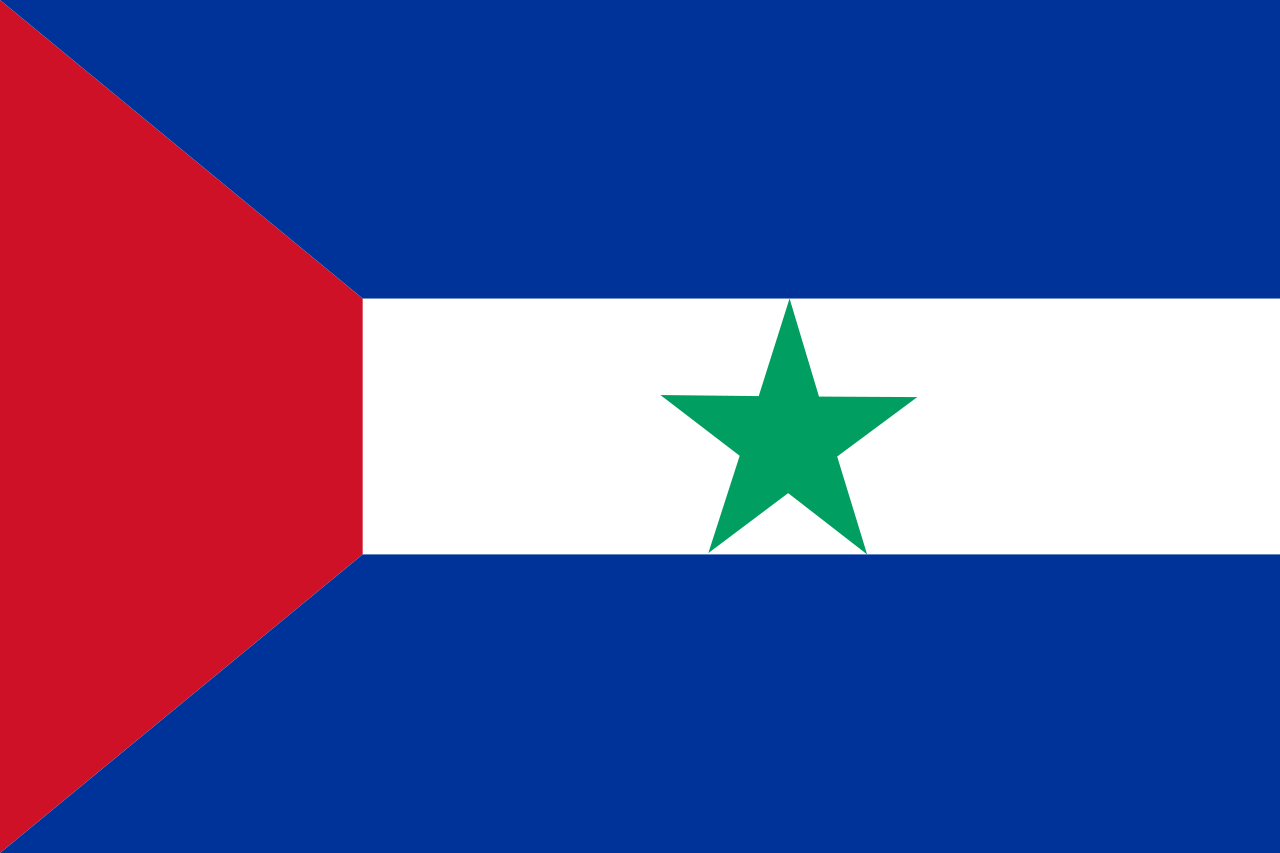
Ministates (or size does matter)

Brčko District
Brčko District

From Wikipedia, the free encyclopedia.​

Brčko District (Bosnian, Croatian, Serbian: Брчко Дистрикт/Brčko Distrikt) is a special political unit, located at the north-east of Federation of Bosnia and Herzegovina, bisecting Republika Srpska.

Officially it was formed in 1999 as a condominium of the Federation of Bosnia and Herzegovina and Republika Srpska, to reflect Brčko and the surrounding areas' multi-ethnic nature and special status within the newly-independent Bosnia.

Established: 5 March 1999
Independence: 1 February 2006 (de facto)
Capital: Brčko
Government:
  • Mayor: Siniša Milić
  • President of the District Assembly: Esed Kadrić
  • International Supervisor: Bruce G. Berton
Currency:
  • Convertible Mark
  • New Republika Srpska dinar (de facto)
  • Euro (de facto)
Area:
  • Total 493 km² (173 sq mi)
Population (2013):
  • Total 93 028
Time zone:
  • CET (UTC+1)
  • Summer (DST) CEST (UTC+2)
Drives on the: right
Calling code: +387 (the calling code of former Bosnia and Herzegovina)
Internet TLD: .ba [**]

[*] Not a government member; the High Representative is an international civilian overseer of the Dayton peace agreement with authority to dismiss elected and non-elected officials and enact legislation.

[**] Former TLD of Bosnia and Herzegovina. Still used not only in Brčko, but also often in Federation of Bosnia and Herzegovina (in addition to its own TLD).


Brcko.png

Map of Brčko District (source)


History

The Brčko District was established after an arbitration process undertaken by the High Representative for Bosnia and Herzegovina. According to the Dayton Peace Accords however, the process could only arbitrate the disputed portion of the Inter-Entity Boundary Line. The Brčko District was formed of the entire territory of the former Brčko municipality, of which 48% (including Brčko city) was in the new formed Republika Srpska, while 52% was in the old Federation of Bosnia and Herzegovina. Since the end of the Bosnian War, the European Union (EU) has maintained a diplomatic peace-keeping presence in the area.

Brčko was the only element in the Dayton Peace Agreement which was not finalized. The arbitration agreement was finalized in March 1999 resulting in a "district" as mentioned above which was to be administrated by an American Principal Deputy High Representative who is also ex officio the Brčko International Supervisor.

Following the failed Bosnian general election in 2006 and subsequent collapse of Bosnia and Herzegovina, the status of Brčko District remained unresolved. Both newly independent Republika Srpska and Federation of Bosnia and Herzegovina originally claimed the area. The District bisects Republika Srpska into two almost equal parts; on the other hand, it is crucial for the access to Bosnia to the Posavina Canton, an exclave of Bosnia.

De iure, since the Federation and Republika Srpska failed to reach the agreement regarding the status of Brčko District, it remains a condominium of both countries within nonexistent Bosnia and Herzegovina. However, in cannot be considered a rump country, since Bosnia and Herzegovina has been officially dissolved by both entities, and Brčko does not consider itself to be a continuation of Bosnia and Herzegovina, neither an independent country.


International Relations

Generally, Brčko District is not considered an independent country. However, it is a member of several international organizations, including Universal Postal Union and the International Telecommunication Union. It is not a member of United Nations and does not issue its own passports. Following previous, still valid agreements, The inhabitants can choose to vote in the elections of either Federation of Bosnia and Herzegovina or Republika Srpska, and can obtain passports of both of the countries - initially, Republika Srpska issued passports only to Serbs, but this limitation has been removed at the insistence of the Office of the High Representative as discriminatory.

Brčko has diplomatic representations (the word "Embasssy" is carefully avoided) in Republika Srpska, Serbia, Croatia, Federation of Bosnia and Herzegovina, European Union and the United Nations. The representatives are issued special travel documents that function as diplomatic passports (while avoiding the word "passport") and enjoy diplomatic immunity (however, apart from these countries, the diplomatic immunity is not recognized anywhere in the world).

Brčko remains reasonably integrated with the economies of both Republika Srpska and Federation of Bosnia and Herzegovina. At the insistence of the International Supervisor mediating the split of Bosnia and Herzegovina, the free movement of people, labour and capital remains valid and all the parties seems to benefit from it.
 
Last edited:
League of Nations
From Wikipedia, the free encyclopedia
League of Nations
The League of Nations (French: Société des Nations, /sɔsjete de nasjɔ̃/ abbreviated as "SDN" or "SdN") was an intergovernmental organisation founded on 10 January 1920 as a result of the Paris Peace Conference that ended the First World War. It was the first worldwide intergovernmental organisation whose principal mission was to maintain world peace. Its primary goals, included preventing wars through collective security and disarmament and settling international disputes through negotiation and arbitration. At its greatest extent from 28 September 1934 to 23 February 1935, it had 58 members.

320px-Flag_of_the_League_of_Nations_%281939%29.svg.png

Semi-official flag (1939–41)

Status: Intergovernmental organisation
Capital:
  • Palais Wilson in Geneva, Switzerland (1 November 1920 - 17 February 1936) (named Hôtel National until 1924)
  • Palais des Nations, Geneva, Switzerland (17 February 1936 - 20 April 1946)
Official languages:
  • French, English [1]
Secretary‑General:
  • 1920–33 Sir Eric Drummond
  • 1933–40 Joseph Avenol
  • 1940–46 Seán Lester
Currency:
  • Swiss Franc (headquarters) [2]
Area:
  • varied; 17635 m² (189.82 sq ft) Palais des Nations
Established:
  • Treaty of Versailles 10 January 1920
  • First meeting 16 January 1920
Dissolved:
  • 20 April 1946
[1] Also local official languages used in the Mandates
[2] Also local currencies in the Mandates

The headquarters of the league were located in the Palais Wilson situated within Geneva, Switzerland, and then were moved to the Palais des Nations on 17 February 1936. The headquarters were considered a sovereign territory of the League.

Although situated in Geneva, the premises of the headquarters were not part of Switzerland. Though a a treaty agreement with the Swiss government and the Canton of Geneva, the headquarters were subject of the cantonal and federal laws. Police, fire protection and utility services were provided by the Swiss Confederation.

640px-Palais_des_nations.jpg

Palais des Nations, Geneva, Switzerland


International Status

The League was an international organization, not a country, and de iure the headquarters was a territory over which it held full sovereignty. The charter also specified that the League is sovereign only over the “permanent headquarters”; thus only Palais Wilson and later Palais des Nations were considered sovereign territories of the League.

A League of Nations mandate was a legal status for certain territories transferred from the control of one country to another following World War I, or the legal instruments that contained the internationally agreed-upon terms for administering the territory on behalf of the League of Nations.

Although not really a League territory, they were often considered such and included under this designation in various lists and treaties..

By the transfer of League assets to the newly established United Nations and dissolution of the League, the Palais des Nations ceased to be a sovereign territory; though it retained extraterritoriality status; the remaining mandates were transferred into United Nations trust territories.

Passports & Citizenship

The League issued two kinds of passports. A diplomatic passport was issued only to high ranking officials and only for work purposes.
Nansen passports were issued as refugee travel documents from 1922 to 1938. They were named after their promoter, the statesman and polar explorer Fridtjof Nansen.

The passport issued by the League was written in French; Nansen identity certificate issued by other countries were often written in French and the language of the country (and they were technically not passports).

The League covenant has no provision for citizenship, and therefore there were no recognized citizens of the League. In case a woman would give birth in the headquarters, most likely the child would be stateless under jus soli, unless the country of the parents follows the jus sanguinis principle. Such a case was however never documented.

The citizenship of the Mandates was separate, and continued after the Mandates gained full independence.
 
Mecca and Medina
Sharifate of Mecca and Medina

Sharifate of Mecca and Medina
شر مكة والمدينة المنورة
Sharāfa Makka wal-Madina al-Munawara

Flag:
Flag_of_MaM.png


Capital: Mecca
Official language: Arabic
Religion: Islam
Government: absolute monarchy
Sharif: Abdullah II bin Al-Hussein
Independence: 10 September 1924 (Saudi-Hashim treaty)
Area: 1433 km² (Mecca 860 km², Medina 573 km²)
Population (2019 estimate): 2.7 million
Currency: Saudi-Hejaz riyal (currency union with the Kingdom of Hejaz)
Time zone: UTC+3 (AST)
Driving side: right
Calling code: +966 (unified Saudi-Hejaz numbering area)
ISO 3166 code: MM
Internet TLD: .mm


Sharifate of Mecca and Medina is a country enclosed within the Kingdom of Hejaz. The country is an absolutist monarchy ruled by a sharif. The country consists of two disjoint parts, some 350 km apart – two cities, Mecca and Medina, traditionally considered the holiest cities in Islam.

History

In their capacity as Caliphs, the Sultans of the Ottoman Empire would appoint an official known as the Sharif of Mecca. The role went to a member of the Hashemite family.

With the outbreak of the First World War in 1914, the Sultan, in his capacity as Caliph, declared a jihad against the Entente powers. The British in particular hoped to co-opt the Sharif as a weighty alternative religious figure backing them in the conflict, as they already had a series of treaties with other Arab leaders in the region. The Sharif was cautious but then agreed to work with the British if they would support a wider Arab revolt. In 1916, the Sharif of Mecca Hussein bin Ali declared himself King of Hejaz as his Sharifian Army participated with other Arab forces and the British Empire in expelling the Turks from the Arabian peninsula.

The First Saudi–Hashemite War came within the scope of the historic conflict between the Hashemites of Hejaz and the Saudis of Riyadh (Nejd) over supremacy in Arabia. It resulted in the defeat of the Hashemite forces and capture of al-Khurma by the Saudis and his allied Ikhwan, but British intervention prevented immediate collapse of the Hashemite kingdom, establishing a sensitive cease-fire that would last until 1924.

The pretext for renewed hostilities between Nejd and Hejaz came when the pilgrims from Nejd were denied access to the holy places in Hejaz. On August 29, 1924, Ibn-Saud began his military campaign against Hejaz by advancing towards Taif, which surrendered without a major struggle. Following the fall of Taif, the Saudi forces and the allied Ikhwan tribesmen moved on Mecca. Abd-ul-aziz ibn Sa'ud came close to defeating Hussein, but Hussein’s request for British assistance was successful, and the British Empire mediated resolution of the conflict. Under British pressure, Hussein abdicated as the King of the Hejaz, in favour of Abd-ul-aziz ibn Sa'ud; and abdicated as Sharif of Mecca in favour of his son Ali. The British guaranteed continued existence of the Sharifate as a separate political entity.

The relations between the Sharifate and the Kingdom of Hejaz remained strained until the death of Ali ibn Hussein. His son ‘Abd al-Ilah of Hejaz started the process of reproachement, not least because of the de facto complete economic dependency of the Sharifate on the Kingdom of Hejaz, culminating in the Treaty of Friendship in 1939, under which the Kingdom of Hejaz is responsible for defence, conduct international relations with non-Muslim countries on behalf of the Shariffate, and allows free passage of Muslim pilgrims to the cities of Mecca and Medina.

The borders of the Sharifate and the Kingdom of Hejaz have not been precisely established until 1974; the original treaties referred only to the “area of the cities”. The amended treaty specified the borders, going mostly by the urban sprawl at the time. Since then, the expansion of the cities into new suburbs created a unique situation, where parts of the municipalities lie across the border in another country.

Religious importance

Mecca is considered the holiest city in Islam, as it is home to the Kaaba ('Cube') and Al-Masjid Al-Ḥarām (The Sacred Mosque). Only Muslims are allowed to enter this city.

The area of Mecca, which includes Mount Arafah, Mina and Muzdalifah, is important for the Ḥajj ('Pilgrimage'). As one of the Five Pillars of Islam, every adult Muslim who is capable must perform the Ḥajj at least once in their lifetime. Ḥajj is one of the largest annual Muslim gatherings in the world, second only to pilgrimages to the mosques of Husayn ibn Ali and his half-brother Abbas in Karbala, Iraq, with attendance reaching 3 million in 2012.

At the heart of Medina is The Prophet's Mosque (al-Masjid an-Nabawi'), which is the burial place of the Islamic prophet, Muhammad. Medina was Muhammad's destination of his Hijrah (migration) from Mecca, and became the capital of a rapidly increasing Muslim Empire, under Muhammad's leadership, serving as the power base of Islam, and where Muhammad's Ummah (Community) developed. In addition to the Prophet's Mosque, the city has the mosques of Qubā’ and al-Qiblatayn ("The Two Qiblahs").


International status

The Sharifate maintains diplomatic relations with 19 other Arabic countries. It does not maintain diplomaitc relations with any country of the non-Muslim world and otherwise conducts its international business via the Kingdom of Hejaz.
The country is not a member of the United Nations. The only major international organization it is a member of is the Organisation of Islamic Cooperation.

The Sharifate is a part of Saudi-Hejaz custom and monetary union, however, there are rather strict border controls around the city of Mecca, because only Muslims are allowed in the city. According to international treaties, special pilgrimage visas issued by the Sharifate are recognized by the Kingdom of Hejaz and the Kingdom of Saudi Arabia and allow the holder to travel to Mecca and/or Medina. The embassies of other countries are located in Mecca, though in theory the embassies of non-Muslim countries would be located in Medina, because of the presence of non-Muslim staff and ambasadors. However, since the “temporary” closing of British embassy in 1941, no non-Muslim country keeps a permanent diplomatic mission to the Sharifate.

The sharifate maintains its police force, but no standing army – the defence is the responsibility of the Kingdom of Hejaz.
 
International Committee of the Red Cross
From Wikipedia, the free encyclopedia​
International Committee of the Red Cross
  • Name: Comité international de la Croix-Rouge (French), International Committee of the Red Cross (English), Comité Internacional de la Cruz Roja (Spanish)
  • Short form: Red Cross
  • motto Inter Arma Caritas
  • Capital: none, headquarters in Geneva, Switzerland
  • Official languages: English, French, Spanish
  • Government: International organization
  • President: Peter Mauer
  • Established: 1863
  • Current status: since Geneva Convention in 1949
  • UN observer membership: 1990
  • International sovereignty: 1949 (de facto), 1993 (de iure)
  • Population: N/A
  • Currency: none; Swiss Franc used in accounting
  • Time zone: CET
  • Drives on the: N/A
  • Calling code: N/A
  • ISO 3166 code: N/A
  • Internet TLD: N/A

The International Committee of the Red Cross (ICRC) is a humanitarian institution based in Geneva, Switzerland. Signatories to the Geneva Convention of 1949 and its Additional Protocols of 1977 and 2005 have given the ICRC a mandate to protect victims of international and internal armed conflicts. Such victims include war wounded, prisoners, refugees, civilians, and other non-combatants. The ICRC won three Nobel Peace Prizes in 1917, 1944, and 1963.

History
The Swiss businessman Henry Dunant witnessed the aftermath of the Battle of Solferino on 24 June 1859. In a single day, about 40,000 soldiers on both sides died or were left wounded on the field. Henry Dunant was shocked by the terrible aftermath of the battle, the near-total lack of medical attendance and basic care. He devoted himself to helping with the treatment and care for the wounded. Lateron he wrote a book entitled A Memory of Solferino, where he explicitly advocated the formation of national voluntary relief organizations to help nurse wounded soldiers in the case of war.
On 9 February 1863 in Geneva, Henry Dunant founded the "Committee of the Five" (with four other leading figures from well-known Geneva families) as an investigatory commission of the Geneva Society for Public Welfare. Their aim was to examine the feasibility of Dunant's ideas and to organize an international conference about their possible implementation. Eight days later, the committee was renamed to the "International Committee for Relief to the Wounded".
In the following years, national societies were founded in nearly every country in Europe. In 1876, the committee adopted the name "International Committee of the Red Cross" (ICRC), which it still holds today. More and more countries signed the Geneva Convention and began to respect it in practice during armed conflicts.
On 16 October 1990, the UN General Assembly decided to grant the ICRC observer status for its assembly sessions and sub-committee meetings, the first observer status given to a private organization. An agreement with the Swiss government signed on 19 March 1993 affirmed the already long-standing policy of full independence of the Committee from any possible interference by Switzerland. The agreement recognizes the international status of the ICRC, gives its headquarters extraterritorial status, grants members and staff diplomatic immunity, exempts the ICRC from all taxes and fees, guarantees the protected and duty-free transfer of goods, services, and money and provides the ICRC with the same privileges as foreign embassies.
The official symbol of the ICRC is the Red Cross on white background (the inverse of the Swiss flag) with the words "COMITE INTERNATIONAL GENEVE" circling the cross. It was later supplemented by four others which are the Red Crescent, Red Star, Red Lotus and the Red Crystal.

Organization
The ICRC is headquartered in the Swiss city of Geneva and has embassies (called Delegations) in about eighty countries. Each delegation is under the responsibility of a Head of delegation who is the official representative of the ICRC in the country. Of its 2,000 professional employees, roughly 800 work in its Geneva headquarters and 1200 expatriates work in the field. In the delegations, the international staff are assisted by some 13,000 national employees.
The ICRC is governed by two bodies, the Assembly and Presidency.

Assembly
The Assembly (also called the Committee) convenes on a regular basis and is responsible for defining aims, guidelines, and strategies and for supervising the financial matters of the Committee. The Assembly has a membership of a maximum of twenty-five members. Working language of the assembly is French. These Assembly members are co-opted for a period of four years, and there is no limit to the number of terms an individual member can serve. A three-quarters majority vote from all members is required for re-election after the third term.
Officially, the assembly members must be citizens of a country with “permanent neutrality”, which in practice limits the membership to Swiss citizens.

Assembly Council
The Assembly elects a five-member Assembly Council that has the authority to decide on behalf of the full Assembly in some matters. The Council is also responsible for organizing the Assembly meetings and for facilitating communication between the Assembly and the Directorate. The Assembly Council normally includes the President, two Vice Presidents and two elected members. While one of the Vice Presidents is elected for a four-year term, the other is appointed permanently, his tenure ending by retirement from the vice presidency or from the Committee.

The President
The Assembly also selects, for a term of four years, one individual to act as President of the ICRC. The President is both a member of the Assembly and the leader of the ICRC, and has always been included on the Council since its formation. The President automatically becomes a member of both the Council and the Assembly, but does not necessarily come from within the ICRC.

Foreign Relations
ICRC has formal diplomatic relations with 80 states and has official relations with the African Union and the European Union. Its delegates generally possess diplomatic status and the delegations enjoy extraterritoriality.
With its unique circumstances, the exact status of the ICRC in international law has been the subject of debate. It describes itself as a "sovereign subject of international law." Its headquarters in Geneva have all been granted extraterritoriality by Switzerland.
Unlike the Sovereign Military Hospitaller Order of Malta or Holy See , organizations sovereign over the headquarters, ICRC never held any territory. The United Nations classify ICRC as a "intergovernmental organization with sovereign status". For internet and telecommunications identification, the ICRC has not been granted a top-level domain or international dialling code
There are differing opinions as to whether a claim to sovereign status has been recognized. Even taking into account the ICRC's diplomatic relationship with other countries, a claim to sovereign status is sometimes rejected. On the other hands, a claim that a sovereign entity does not have to be a country uses ICRC as a primary example of this. This position appears to be supported by the number of nations extending diplomatic relations to the ICWC. As a subject of international law, it enjoys certain powers, but not the entire set of powers of sovereignty.

Passports
ICRC issues two kinds of passports. Diplomatic passports are issued to the members of the Assembly, the Delegates and high ranking employees of the Delegations. These passports grant the holders full diplomatic immunity (with the exception of being in the country of their nationality). Service passports are issued to other employees of the Delegations, field medical personnel and other employees. These are always issued for a fixed term and specific purpose. Service passports holders usually enjoy a limited form of diplomatic advantages (such as free passage), but this is regulated by bilateral treaties between ICRC and the respective countries.
ICRC Emergency travel documents are not passports, but documents confirming the identity of the bearer used for international travel, these are issued for humanitarian purposes to persons that are unable to obtain other travel documents, always for a specific fixed single travel.
Unlike other countries’ travel documents, both diplomatic and service passports, as well as the emergency travel documents always state the nationality of the bearer.
ICRC passports played a role in the Iranian Hostage Crisis - documents declassified in 1997 revealed the stunt orchestrated by CIA where several senior USA diplomats were able to leave Iran by pretending to be ICRC functionaries, using diplomatic passports officially issued by the ICRC. This soured the relations with the Islamic Republic of Iran.
 
Sevastopol
Sevastopol
Севастополь

From Wikipedia, the free encyclopedia.​
Flag:
Flag_of_Sevastopol.png


Name: Sevastopol
Capital: Sevastopol
Official languages: Russian, Ukrainian [a]
Government: City state led by a City Council, represented by a Chairman (until 2014); Legislative assembly (as a federal subject of Russia, after 2014)
Chairman of the City Council (as of 2014): Yuri Doynikov
Chairman of the City Council in exile (Kiev): Volodymyr Dudka [b]
Chairman of the City Council in exile (USA): Valery Tarasenko [c]
Chairman of the Legislative Assembly (Russian administration): Vladimir Nemtsev
Independence (from Ukraine): 1 September 1992
Annexed by Russia: 23 February 2014
Currency: Sevastopolian rouble (de iure until 2014); Russian rouble (de facto since 1992, de iure since 2014)
Time zone: EET, EEST (until 2014); UTC+3 (after 2014)
Founded: 1783 (240 years ago)
Government: independent city / federal subject of Russian Federation (since 2014)
Area: 864 km²
Population (2014 estimate): 510 000
Demonym(s): Sevastopolitan, Sevastopolian
Drives on: right
Calling code: +7; +380 (between 1995 and 2014); +384 (after 1995) [d]
ISO 3166 code: SP
Internet TLD: .sp, .ru [e]

[a] The status of Ukrainian as an official language was inherited from the Ukrainian SSR and never revoked. However, the language of the administration has always been solidly Russian.

[b] The City Council in exile was set up in Kiev by the Ukrainian government, following the annexation of Crimea. Officially recognized only by Ukraine, the Council does not seem active anymore (as of 2023).

[c] Set up by a Ukrainian businessman Valery Tarasenko. It seems the goal was to fraudulently get access to the City assets in the USA. As of 2023, a US federal investigation is still ongoing. The Council ceased to function after the mysterious disappearance of Valery Tarasenko during his trip to Quebec.

[d] The city (together with Russia and Kazakhstan) kept the +7 international dialing prefix of the USSR; in addition it has been connected to the Ukrainian network with the +380 prefix, with the connection between the two networks unreliable to such an extend that companies and offices tended to have two separate landlines, one Ukrainian, one Russian. The city never developed its own fixed line telephone numbering plan. +384 has been officially to the city assigned by the ITU and was used by local mobile phone operators; +384 numbers have been gradually phased out after 2014, but the prefix (as of 2023) still works as an alias to the +7 896 Russian local prefix.

[e] Following the annexation by Russia all organizations and private persons in Sevastopol were forced to switch to the .ru domain. A formal request to delist the domain from root DNS servers has been initially approved by IANA; following the invasion of Crimea, the deletion has been put on hold and the .sp domain continues to be used by foreign based entities.
 
Last edited:
Welcome back, excellent work! Only quibble is that while not all of the entries in this thread are independent countries, I have to wonder if it makes sense to present some sort of unusual amorphous status, since OTL Sevastopol was already turned into a Russian federal city? What if ATL Russia treated it like a sovereign city-state like it recognized Abkhazia, and the LPR and DPR before the September 2022 referenda. Otherwise it seems pretty close to actual reality.
 
I have to wonder if it makes sense to present some sort of unusual amorphous status, since OTL Sevastopol was already turned into a Russian federal city? What if ATL Russia treated it like a sovereign city-state like it recognized Abkhazia, and the LPR and DPR before the September 2022 referenda. Otherwise it seems pretty close to actual reality.
Well, in this TL, Russia (and the whole world) did recognize Sevastopol, until they found better utility in annexing it (basically as a legal precursor to annexing Crimea a month later). I have actually a bit of background being worked on, and I do not want to invent butterflies to distract from the basic premise (existence of an independent, though heavily Russia-dependent city state), thus the TL is quite parallel to OTL (too parallel even for my taste, but well, whatever...)
 
Modern History of Sevastopol

Sevastopol is the largest city in Crimea and a major port on the Black Sea. Due to its strategic location and the navigability of the city's harbours, Sevastopol has been an important port and naval base throughout its history. Since the city's founding in 1783 it has been a major base for Russia's Black Sea Fleet, and it was previously a closed city during the Cold War.

In 1954, both Sevastopol and the remainder of the Crimean peninsula were administratively transferred from being territories within the Russian SFSR to being territories administered by the Ukrainian SSR. Administratively, Sevastopol was a municipality excluded from the adjacent Crimean Oblast.

As Leonid Kravchuk mentions in his memoires, part of the Belovezha accords of December 1991 that dissolved the USSR was a semi-secret meeting with the Russian president Boris Yeltsin, where the question of Crimea was raised up. As he recalls “It would be enough if Boris Nikolaevich just asked and we would have transferred Crimea to Russia, no demands, no conditions. To be honest, I was quite surprised when he suggested a referendum, which we all, of course, expected to be won by pro-Russia inhabitants.”

The two referenda (one in Sevastopol and one in Crimea) were planned for August the next year, with three choices: continue as a part of Ukraine, transfer to Russia, or independence. The winning questions had to get over 50% votes, in case no answer got more than 50%, a second round with the two top questions will be organized.


However, a few days before the referenda, the tension between Boris Yeltsin and the Supreme Soviet of Russia escalated and the chaotic fighting between two army groups erupted in the streets of Moscow (eventually leaving Boris Yeltsin and half of the deputies dead). Ukrainian authorities carried on the referenda, apparently under the hope of a favourable vote influenced by the ongoing fighting in Russia. The Crimean referendum, was narrowly in favour of staying in Ukraine, while in the Sevastopol one both pro-Ukraine and pro-Independence choices were to be voted on in the second round in two weeks. By that time, the fighting in Russia was over, and the second round was decisively in favour of independence.


Thus the city became independent in the middle of an economic turmoil, increasing unemployment and social unrest, and destabilization of both rouble and karbovanets. The city council reacted predictably, by introducing its own currency, the Sevastopolian rouble (initially at par with the Soviet rouble) and uncontrolled printing of money, with predictable consequences.

However, the city inherited a major asset - an ex-Soviet naval base, of eminent interest to both Russia and Ukraine. What followed was the so-called “bidding war”, when the countries tried to outbid one another for the lease of the base. Eventually won by Russia for an outrageous sum of money (denominated in US dollars and paid through the years mostly in oil, natural gas, electricity and food). The influx of money helped weather the worst effects of post-Soviet collapse, but did not bring that much prosperity to a common citizen - most of the money went towards ill-conceived grandiose projects and likely directly contributed to sky-high corruption (even by Russian or Ukrainian standards), and the city became almost completely dependent on Russia.

With the population mostly keeping pro-Soviet sentiment and continuing ties with Russia and the alienation of Ukraine, the referendum in February 2014 on the annexation of Sevastopol to Russia end predictably with overwhelming 87% of votes in favour, and the annexation was initially accepted by the international community. However, the unexpected occupation of Crimea one week later greatly damaged any credibility of Russia and the annexation is often regarded as an act of occupation, together with the whole Crimea.
 
East Lusatia
East Lusatia
From Wikipedia, the free encyclopedia
  • Name: (Eastern) Republic of Lusatia (German: Republik Lausitz; Lower Sorbian: Republika Łužyca; Upper Sorbian: Republika Łužica; Polish: Republika Łużyce, informally often in English: Transnissia)
  • Short form: Lower Sorbian: Łužyca; Upper Sorbian: Łužica; Polish: Łużyce
  • Capital: Budyšin (claimed), Zhorjelc (seat of the parliament)
  • Official languages: Sorbian (Lower & Upper; Upper Sorbian has been used almost exclusively, though communication in Sorbian is rare), Polish (de facto working language of the country)
  • Government: Parliamentary republic
  • President: Rafael Gronič
  • Established: 1945 (independence of Lusatia), 1948 (People’s republic of Lusatia proclaimed)
  • Population: 20000 (2012 estimate)
  • Area: 2080 km²
  • Currency: Polish złoty (currency union with Poland)
  • Time zone: CET
  • Drives on the: right
  • Calling code: +48 75 (integrated with the telephone numbering plan of Poland)
  • ISO 3166 code: LW
  • Internet TLD: .lw (.pl is often used as well)

Modern History

During the Yalta Conference, the allies agreed upon the creation of an independent Lusatia under the "protection and patronage" of Czechoslovakia. The borders were provisionally drawn according to the proposal of Jan Cyž, the leader of the Sorbian National Council in exile, and his collaborator Jan Meškank. The proposal, which may have been over-optimistic, included a narrow strip on the right bank of the river Neisse, an area historically belonging to Lusatia but with very few, if any, Sorbian inhabitants. The borders remained largely unchanged after the end of World War II, with only minor adjustments.

Following the end of the war, the re-established Czechoslovak government expressed, at best, lukewarm support for the Lusatian case, and Lusatia was set up on the path towards complete independence. Located between Czechoslovakia, Poland, the Soviet occupation zone and the US occupation zone, it soon became the focus of a political battle over the influence over the small country.

The right bank of the river was initially occupied by the Red Army and later by the Polish army, in accordance with the Yalta agreements. Initially, there was no internal division of the country. However, in 1948, when it became obvious the USSR and the USA would remain enemies and Germany would remain divided, the People’s Republic of Lusatia was proclaimed. It was led by Pawoł Nowotny and controlled only the right bank of the river Neisse. Initially recognized only by the USSR and their aligned countries, the republic remained firmly under Polish control ever since.

In 1951, the treaty of mutual friendship and cooperation with Poland was signed, effectively making the country a protectorate of Poland - border controls were abolished and Poland assumed responsibility for defense. This was followed by a full custom and monetary union in 1952, along with mutual recognition of identification documents, education degrees and other certificates.

The rise of Solidarność, the end of communist rule in Poland, the reunification of Germany and the breakup of the Soviet Union initially had no impact on the politics of East Lusatia; there was no revolution, no public protests, the government continued to espouse socialist rhetorics, seemingly paying no attention to the events in the outside world. However, its ability to control information flow and movement of the population stopped, but only gradually the grip of the Lusatian Workers’ Party on the society diminished, under pressure from the Polish government. The first free multiparty elections were held in 1997 (unsurprisingly, during the economic crisis, the LWP won the majority anyway, but had to create a coalition government and ease restrictions). Only after the turn of the 21st century did private businesses begin to thrive. Nevertheless, the economy remains heavily subsidized and reliant on monetary and goods (such as oil and natural gas) support from Poland.

By today, East Lusatia is a part of Poland in all but name. Majority of the inhabitants are native Polish speakers (and almost universally dual Polish citizens), and the common derogatory term in Poland for the country is “Łużycka gmina”.

Language

While the official language is Sorbian (in both variants, Upper and Lower), the everyday language is Polish. Sorbian (Upper) is spoken mostly by elderly people. Younger generation uses Polish almost exclusively, and whatever Sorbian they may speak is heavily Polonized.

The East Lusatia had practically zero native Sorbian speakers in 1948 (mostly officials, teachers and their families coming from the western part of Lusatia). This was followed by forcible expulsion of Germans, which resulted in significant depopulation. It is estimated that up to three quarters of the population either fled before the end of WWII or were expelled before 1948. Those who chose to remain and spoke any scrap of any Slavic language claimed to be Lusatian, but German still remained the majority language, albeit discouraged. However, the subsequent influx of Polish settlers (mainly from areas annexed by the Soviet Union) definitely shifted the linguistic balance away from German, but in favour of Polish as the dominant language.

Officially, the laws and other government decrees are published in Sorbian, with the Polish versions considered to be unofficial translations. However, in practice, the “official '' Sorbian texts were riddled with polonisms and numerous grammatical errors and mistakes ever since the 1970s, presumably after the last native speakers of the translation office retired - though, the language quality tremendously improved after 1990. A minor scandal erupted when it was discovered that the Office of the Parliament and other government bodies were submitting drafts of documents in Polish to an officially procured translation agency, and the agency was “outsourcing” the translations to West Lusatian companies, while charging many times the real expenses to the government, routinely submitting confidential and even secret documents to West Lusatian companies. A financial connection of the company to the minister of interior has been rumoured, but no official investigation ever took place and no one has been charged. However, as a consequence, the parliament and the government “temporarily” stopped publishing texts in Sorbian, continuing exclusively in Polish - and with this, Sorbian disappeared almost completely from public life. Even Telewizja Serbska switched almost completely to broadcasting in Polish, with Sorbian pressent only in sporadic movies and soap operas imported from West Lusatia (Polish TV dominates the local market anyway).

International Relations

East Lusatia maintains embassies in 67 countries, though they are often collocated with the Polish embassies. Foreign policy always closely followed the Polish one, with the exception of the years 1989 - 1997, where Lusatia started to follow increasingly isolationist policy, reversed only after the 1997 elections. The country is not a member of the EU, but it is governed by separate treaties regulating its status, and thanks to close integration of the economy with Poland, the inhabitants practically do not see a difference. The country is the member of the UN and other international organizations (though often delegating execution of the membership to Poland, thus effectively giving Poland two votes) and by the second half of the 20th century it was diplomatically recognized by all the sovereign countries in the world (with the exception of West Lusatia). The visa policies for Lusatians usually mirror those appliled to Polish citizens.

Although both East and West Lusatia never stopped to declare their desire to reunify (and claim the territory of the whole Lusatia), the popular support is just not there - Polish speaking East Lusatian inhabitants do not particularly wish to become citizens of a German-Sorbian speaking country that has been separated by the Iron Curtain for decades, and West Lusatians have no desire to annex small strip of land with no economy value and a few thousands of Poles. Thus the countries will probably remain separated for a foreseeable future. Thanks to EU’s open borders and free movement of people and services, this is not an important issue anymore.
 
Aden
From Wikipedia, the free encyclopedia​
Name: Aden (Arabic: عَدَن)
Capital: Aden
Official languages: Arabic, English
Government: Parliamentary republic
President: Mohammed Basindawa
Independence: 1 January 1972 (from Pakistan)
Population (2023 estimate): 650 000
Area: 192 km²
Currency: New Adeni dirham
Time zone: UTC+03:00
Drives on the: right
Calling code: +881
ISO 3166 code: AN
Internet TLD: .an, .عَدَنْ
Flag:
jO0DBnWGkIJX_vWhFL0XwJxtLrjAJd1vUmOfMGIkmSoqq2DWJfzFWbP1mCIJzwZ400pxDoOQogUfwEdGoMIx8SvG2143H1mTNCFkMu4-Je8V9hxDBvXEigFBq2lMfGCPnbZzNXoQEqMg4jsKQCpIAtk


Aden (Arabic: عَدَنْ) is a country located in the southern part of the Arabian peninsula, positioned near the eastern approach to the Red Sea. It is situated approximately 170 km (110 mi) east of the Bab-el-Mandeb strait and north of the Gulf of Aden. With its strategic location on the coastline, Aden serves as a gateway between the Red Sea and the Arabian Sea, making it a crucial maritime hub connecting Africa, Asia, and the Middle East. As of 2023, Aden City has a population of approximately 650 000 residents.

Modern History
Following the capture of the port of Aden by forces of the East India Company in 1839, the town and immediate surrounding area under direct British rule, known as the Aden Settlement, had been a dependency of the Bombay Presidency.
Its original territory was enlarged in 1857 by the 13 km² island of Perim and in 1868 by the 73 km² Curia Muria Islands. The Curia Muria Islands were transferred to Muscat and Oman following the referendum in 1947, on the eve of the Partition of India.

The Settlement's remote location was bound to cause difficulties and Aden’s history under British rule had been marked by administrative confusion and complication. The issue gained urgency at the end of the 1920s when discussions on constitutional reforms in India began. Attempts at removing Aden from India’s administrative reach and making it either a Crown Colony or a separate sui generis unit met with strong resistance from well-established and powerful local Indian community in Aden, and the plans were never elaborated on before WWII broke.

When Pakistan gained independence in 1947 after the Partition of the British Indian Empire, which awarded separate statehood to its Muslim-majority regions, Aden became part of the country. This was resented by both the Indian community (that preferred to stay as part of India or even the British empire) and local Arab population that had little or no connection to the remote Pakistani government.

Simultaneously, Great Britain negotiated the lease of Little Aden (with the newly constructed British Petroleum oil refinery) for 40 years, including a British military base and an option for Pakistan to buy out the refinery from British Petroleum after the lease.

Surprisingly, the transfer of power was peaceful and uneventful, with both Indians and Arabs united in their silent opposition against the new authorities. Nevertheless, the city retained quite a lot of autonomy, the reach of Pakistani authorities was quite mild. In particular, the police force continued unchanged from the colonial period, the fact that contributed to the stability and prosperity, and played a key role in (despite all odds) ensuring a peaceful transition towards independence. The continued presence of British forces likely contributed to the following period of stability.

The independence

During the Bangladesh Liberation War, calls for Aden independence started to mount. Preoccupied with the situation in East Pakistan, the Pakistani government failed to react and independence was first declared by the city council on 12 December 1971, bypassing local Pakistani authorities. Formally, the Independence Act was signed on 1 January 1972, and this day is celebrated as Independence Day.

What followed was a period of rapid development and economic growth, earning the city the nickname “Arabian Singapore”. In 1987, the British lease on Little Aden expired and the peninsula was returned to the city state.

The growth and development was abruptly cut short, when in 1994 the Summer Civil War broke out in Yemen. Unexpected and surprising attack by southern separatist forces on 25 May on Aden quickly overwhelmed inadequate Adeni military forces and the following looting, killing and rapes went into history under the name of Massacre of Aden. This was devastating for the local Indian community; it is estimated that about 20000 Adeni civilians died in the following days, about 15000 of them were Indians.
Caused by artillery fire, the destruction and fire in the petrol refinery in Little Aden marked the biggest ecological catastrophe of the decade.
Hastily organized military intervention by India, United Kingdom and Saudi Arabia was successful in driving the Southern Yemeni forces out of the city and indirectly contributed to the North victory and subsequent re-unification of Yemen. The peacekeeping forces established a 1km wide demilitarized zone around the city, the arrangement that remains until today.

By 2024, although Aden is just a husk of its former self, the city is again bustling with activity, the economy is going better and the future prospects are looking good - as long as the peace lasts.
 
The City of London

Through a quirk of history the square mile the contains the City of London was never formally made part of either England or the United Kingdom and retained its own unique government with the Lord Mayor at its head. This republic in the heart of the capital of England is perhaps the wealthiest country in the world as a major centre of international finance yet only has a resident population of around 14,000 people, though 10's of thousands work there every day. In theory it still uses the old English Pre Decimal currency of Pounds Shillings and Pence but in practice the decimal Pound used in the rest of Britain is accepted by every business in the city.
"Republic" and "Lord Mayor"? That does not integrate well, neither the United Kingdom. However, this might actually work (without the "Republic" part) - the City of London is made into something akin to a Crown Dependency, responsible only to the monarch (or King-in-Council in modern times) and thus not a part of the UK. This might happen either centuries ago, or in the 20th century, where the CoL is made into an independent capital of a reformed, supranational British Commonwealth consisting of separate sovereign countries.
 
Top