Could you perhaps have phrased this more civilly?Get rid of the stupid jungle gym and it would be fine.
You are using an out of date browser. It may not display this or other websites correctly.
You should upgrade or use an alternative browser.
You should upgrade or use an alternative browser.
Map Thread XXII
- Thread starter Balkanized U.S.A
- Start date
I made this for my own reference reasons but I figure I'll post it.
ITTL France did not form in the medieval era, rather the North was dominated by the Kingdom of Neustrie*, while the South was comprised of various Occitan polities who managed to retain their independence; it would not be until 1800 that the various polities agreed to form a single, federal country.
*After initial attempts by (ATL) King Charles IV to unify/conquest Northern France failed the Neustrie was founded to show a continuation of the Carolingian past, but also recognizing that Francia was not united.
Where are 16 and 17 exactly? 18 is Fiji of course, but I can't place the other two États d'Outre-mer.I made this for my own reference reasons but I figure I'll post it.
ITTL France did not form in the medieval era, rather the North was dominated by the Kingdom of Neustrie*, while the South was comprised of various Occitan polities who managed to retain their independence; it would not be until 1800 that the various polities agreed to form a single, federal country.
*After initial attempts by (ATL) King Charles IV to unify/conquest Northern France failed the Neustrie was founded to show a continuation of the Carolingian past, but also recognizing that Francia was not united.
Where are 16 and 17 exactly? 18 is Fiji of course, but I can't place the other two États d'Outre-mer.
16 (left) and 17 (right) are the two boxes above it.
Also, since it's maybe not obvious in isolate, 16 is OTL Azores and 17 is OTL Martinique.
Last edited:
Ah! I didn't look at the Azores and Martinique isn't in any version of QBAM (understandable, given its small size), so that makes sense.16 (left) and 17 (right) are the two boxes above it.
Also, since it's maybe not obvious in isolate, 16 is OTL Azores and 17 is OTL Martinique.
Ah! I didn't look at the Azores and Martinique isn't in any version of QBAM (understandable, given its small size), so that makes sense.
The Martinique in the map is actually one I did myself for a different map along while ago so it's not actually part of any of the map systems on the site.
Last edited:
It’s architecturally ugly and therefore psychologically harmful to repeated viewing. It’s a construction of an emptiness, subconsciously suggesting that the damage done by the event will never be repaired and that what is missing in the lives of the affected will never be filled in. There are far more humanistic ways to represent the loss and symbolize the event. And I personally don’t like “wasting space” on things that aren’t in some way physically useful. Art is useful, but it has to be art.Could you perhaps have phrased this more civilly?
LFG, that would be awesome!You know, I think I'm adding a world map for the following map by @Keperry to my to-do list.
Visual appeal is far from objectiveIt’s architecturally ugly and therefore psychologically harmful to repeated viewing.
This is a PURELY subjective interpretation. Just because an architectural design being ugly to someone can be psychologically and physically harmful, this does not mean that your particular interpretation, that "the damage done by the event will never be repaired" is in any way inherent to all people. For me for example it did not come to mind at all.It’s a construction of an emptiness, subconsciously suggesting that the damage done by the event will never be repaired and that what is missing in the lives of the affected will never be filled in. There are far more humanistic ways to represent the loss and symbolize the event.
How is this not art? You not liking it does not discredit it as art. Many would consider any modernist architecture "non-art" but that doesn't mean they're objectively correct, for example.And I personally don’t like “wasting space” on things that aren’t in some way physically useful. Art is useful, but it has to be art.
Calling the design a "stupid jungle gym" and implying that the overall composition is only "fine" if they get rid of that, and phrasing it more like a command, remains rude and uncivil. Even if you were OBJECTIVELY right you would be in no position to speak to another person that way, even less given that you are expressing a totally subjective individual preference.
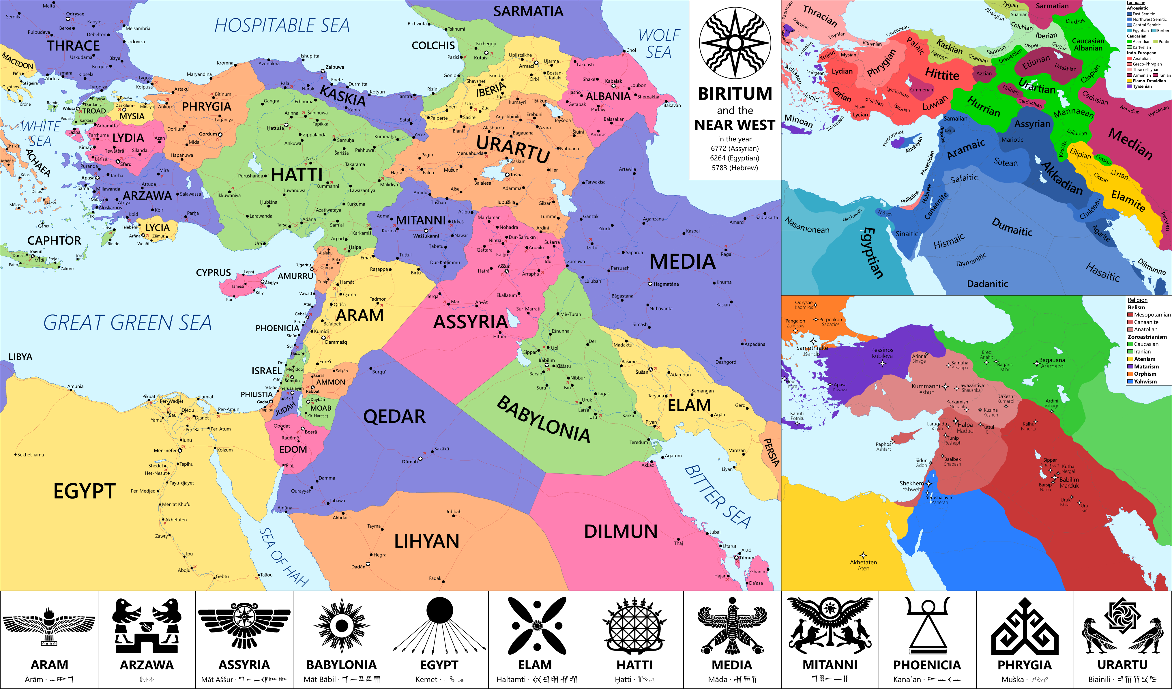
Considering Elamo-dravidian isn't widely recognized either I think the map maker is using some less accepted language family and theories.aaaaaaaaaaaaaaaaa Minoan and Eteocypriot should be classed as language isolates.
aaaaaaaaaaaaaaaaa Minoan and Eteocypriot should be classed as language isolates.
I am indeed (don't forget the Alarodian!) and, knowing nothing about linguistics, I refuse to justify my decisions on any grounds more substantial than "I thought it would be fun"Considering Elamo-dravidian isn't widely recognized either I think the map maker is using some less accepted language family and theories.

(In all seriousness though if dealing with ancient poorly-attested languages it's basically impossible to avoid conjecture so I figured I might as well go all-in with it and save myself some colors on the map, rather than the more complicated, and imo less interesting, but also conjectural route of making them all their own isolates)
A masterpiece like the rest of this series. I have some questions: what's the Year Zero of the calendar in use? From which languages is xanthean derived? How much the habitability of Mars has changed? I remember in the Caprisian Wars map it was shown that only the lowest parts of the planet are in habitable and the higher altitudes were only a place for adventurous caravans with a lot of equipment that tried alternative routes between other low altitude places. In this map it all seems so uniform, is it just ignoring the thing because it's not a map made to show lines of communication or has the situation changed?
For some ancient history: The Highland Paths of the Caprisian Wars
For the stuff of myth and legend: The reunified Soviet Union in exile, 2312
Xanthe is one of the oldest-inhabited regions of Mars, with archeological evidence suggesting it was colonized directly from Earth - though this remains a controversial conclusion. Its position straddling the Caprisian Straits into the deep and rich Mariner's Valley made it one of the key political players in Western Mars, alongside other powers like Kasei, Tempe, and the Margaritafers. After peaking in strength after its victory in the Caprisian Wars of the 7th and 8th centuries, its power was slowly eclipsed as the rise of the powerful North Margaritafer province, economically buoyed by caravan routes across Arabia, made it difficult for it to leverage its geopolitical situation.
Currently, Xanthe is a middling power, though it remains one of the richer societies in the otherwise poor Northwest Mars region. It retains age-old claims over minor islands in the straits, but these disputes have not been active for decades now. It is gradually transitioning from its agricultural economy to one focused on refining and manufacturing. Meanwhile, its hereditary governors have in recent history devolved more power to their assemblies - partially a bid to cool the simmering ethnic tensions caused by its diverse population, split three ways between the various craterlanders of the north who have always made up the political elite, the seafaring merchants of the littoral south and east, and the rough hetmen of the west. But will liberalization create, at long last, a united society, or tear back open the wounds of the separatist conflicts of the late 1300s?
Great map! I'm glad you posted maps from your Patreon here after a while.A map for the old alternate history travel guides world "Mongol Japan", in which the Mongols succeed in conquering Japan, only for the tail to eventually start wagging the dog all over the place.
View attachment 874117
Usually, I'm not particularly eager to interrupt someone's hour of glory, but here's my version of Mongol Japan that I made back in 2018 and never posted here. Based on the description from this thread link.
it's not my birthday : (Great map! I'm glad you posted maps from your Patreon here after a while.
Usually, I'm not particularly eager to interrupt someone's hour of glory, but here's my version of Mongol Japan that I made back in 2018 and never posted here. Based on the description from this thread link.
So which country is the least controlled by Japongolia?
I like the lost Mongol fleet colony! I vaguely remember a tl here based on this. And Poul Andersons Time Patrol story where they thwart the lost Mongols..Great map! I'm glad you posted maps from your Patreon here after a while.
Usually, I'm not particularly eager to interrupt someone's hour of glory, but here's my version of Mongol Japan that I made back in 2018 and never posted here. Based on the description from this thread link.
View attachment 874812
The Tsefevin Republic is the only Jewish majority state in the world and was established by the British and Americans in the year 1948. In its beginning years instability engulfed the region since Canada still claimed the territory and the majority of the population was not Jewish. Some people were considering to end this state. In 1958, the project of Judea began to operate which encouraged Jews around the world to immigrate to the Tsefevin republic. In 1970 the nation reopened relations with Canada and joined NATO in 1972. As of recently the republic has been isolationist except to Canada and the US.
Last edited:
What if every proposed Jewish state was established?
The Tsefevin Republic is the only Jewish majority state in the world and was established by the British and Americans in the year 1948. In its beginning years instability engulfed the region since Canada still claimed the territory and the majority of the population was not Jewish. Some people were considering to end this state. In 1958, the project of Judea began to operate which encouraged Jews around the world to immigrate to the Tsefevin republic. In 1970 the nation reopened relations with Canada and joined NATO in 1972. As of recently the republic has been isolationist except to Canada and the US.
Pretty sure you messed up the link at the top, right now it goes to a search rather then any specific post
The Tsefevin Republic is the only Jewish majority state in the world and was established by the British and Americans in the year 1948. In its beginning years instability engulfed the region since Canada still claimed the territory and the majority of the population was not Jewish. Some people were considering to end this state. In 1958, the project of Judea began to operate which encouraged Jews around the world to immigrate to the Tsefevin republic. In 1970 the nation reopened relations with Canada and joined NATO in 1972. As of recently the republic has been isolationist except to Canada and the US.
The Tsefevin Republic is the only Jewish majority state in the world and was established by the British and Americans in the year 1948. In its beginning years instability engulfed the region since Canada still claimed the territory and the majority of the population was not Jewish. Some people were considering to end this state. In 1958, the project of Judea began to operate which encouraged Jews around the world to immigrate to the Tsefevin republic. In 1970 the nation reopened relations with Canada and joined NATO in 1972. As of recently the republic has been isolationist except to Canada and the US.
I’m pretty sure there’s not a million people in that region today, and I doubt the establishment of Jewish state there would make the non-Jewish population explode in size.
Share: