Indeed I did, I even have friends from there :'0Tennessee is there on both maps? Did you mean Kentucky?
Shameful Display, I'm sorry and defiently tired...
Indeed I did, I even have friends from there :'0Tennessee is there on both maps? Did you mean Kentucky?
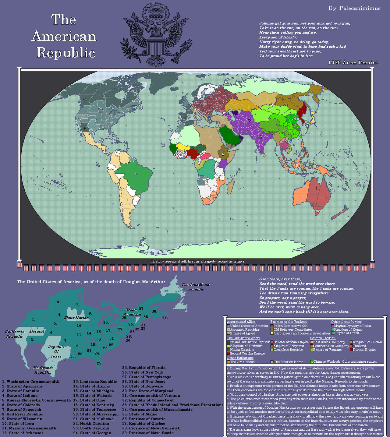
Ah, the lore as it were is that the British mediated a peace after the Confederates win Antietam and proceed upward. Due to difficulty deciding where the states would go, Missouri and Kentucky are placed under interim governments and plebiscites are held to see which state wants to go where. Kentucky votes to re-join the union, however the interim government of Missouri, under the head of it's Lieutenant Governor before the war (Thomas Caute Reynolds, a confederate), ended up manipulating the votes to ensure Missouri joined (this was the 1860's so election fuckery is a bit easier).Indeed I did, I even have friends from there :'0
Shameful Display, I'm sorry and defiently tired...
Beautiful map - I've never quite figured out how to get shaded relief like that myself. Did you use QGIS for that?The Emirate of Dhofar
Seconding @Ulyanovsk what tools did you use for this?
The Emirate of Dhofar
Situated beyond the great wilderness of the Empty Quarter, between the great regions of Yemen and Oman, the Emirate of Dhofar is perhaps the most remote kingdom in all of Arabia. Despite its isolation, the region is blessed by the annual Monsoon of Khareef which makes the capital region straddled by the Jabal al-Qara mountain range into a lush landscape suitable for extensive agriculture, in the otherwise arid Arab peninsula.
Yea i used Qgis with a heavily modified digital elevation model which i edited in GIMPBeautiful map - I've never quite figured out how to get shaded relief like that myself. Did you use QGIS for that?
I’m honestly unsure whether Kentucky would rejoin the Union or not. It’s weird to think about, but a major reason why Kentucky stayed with the Union is because early on they actually thought that the Union would better protect the institution of slavery in Kentucky than the Confederacy. After all, in their mind, seceding from the Union would basically nullify the Fugitive Slave Act, making it much easier for slaves to escape as they merely needed to cross over into Indiana or Ohio instead of Canada. Considering that TTL has both Missouri and West Virginia in the Confederacy, I could see the Union being much more abolitionist/pro-civil rights even compared to our own timeline, making it likely that Kentucky ends up voting to join the Confederacy on account of the latter’s defense of slavery.Ah, the lore as it were is that the British mediated a peace after the Confederates win Antietam and proceed upward. Due to difficulty deciding where the states would go, Missouri and Kentucky are placed under interim governments and plebiscites are held to see which state wants to go where. Kentucky votes to re-join the union, however the interim government of Missouri, under the head of it's Lieutenant Governor before the war (Thomas Caute Reynolds, a confederate), ended up manipulating the votes to ensure Missouri joined (this was the 1860's so election fuckery is a bit easier).
Ironically I have two things in mind in this regard:I’m honestly unsure whether Kentucky would rejoin the Union or not. It’s weird to think about, but a major reason why Kentucky stayed with the Union is because early on they actually thought that the Union would better protect the institution of slavery in Kentucky than the Confederacy. After all, in their mind, seceding from the Union would basically nullify the Fugitive Slave Act, making it much easier for slaves to escape as they merely needed to cross over into Indiana or Ohio instead of Canada. Considering that TTL has both Missouri and West Virginia in the Confederacy, I could see the Union being much more abolitionist/pro-civil rights even compared to our own timeline, making it likely that Kentucky ends up voting to join the Confederacy on account of the latter’s defense of slavery.
Any recommendations for QGIS tutorials?Yea i used Qgis with a heavily modified digital elevation model which i edited in GIMP
Any recommendations for QGIS tutorials?

Revenge of the Dutch.The Batavians teach Caligula how to defeat the sea; Neptune takes a massive L.
The Batavians teach Caligula how to defeat the sea; Neptune takes a massive L.
Did they raise the ocean floor? Wtf is actually portrayed here? It's very intriguing.The Batavians teach Caligula how to defeat the sea; Neptune takes a massive L.
The fact that Caligula declared war on Neptune and had his soldiers stab the water and collect seashells as trophies (which tbh I'm pretty sure he was trying to humiliate them because they refused to get on ships to go conquer Britain), combined with this proposal by some Dutch dude. And we all know what the Dutch are famous for.Did they raise the ocean floor? Wtf is actually portrayed here? It's very intriguing.
Ah. Well the engineering capabilities of this Rome and the implications of what else it could do if it has done this are pretty monumental 0:The fact that Caligula declared war on Neptune and had his soldiers stab the water and collect seashells as trophies (which tbh I'm pretty sure he was trying to humiliate them because they refused to get on ships to go conquer Britain), combined with this proposal by some Dutch dude. And we all know what the Dutch are famous for.
As a certified "computer person" this sounds like PEBCAK... (Google if you need to)Actually, I found a much less cumbersome work-around than what I found in the Google search... I went in and did a repair/reset on the Windoze Photo App...
Now, as to why that app would prevent the system from even recognizing a PNG as something downloadable, I don't have a clue
I don't think I've actually liked any OS they've brought out since 7... and that was a long time ago...
Ha! I'd say your assessment is correctAs a certified "computer person" this sounds like PEBCAK... (Google if you need to)

 Source