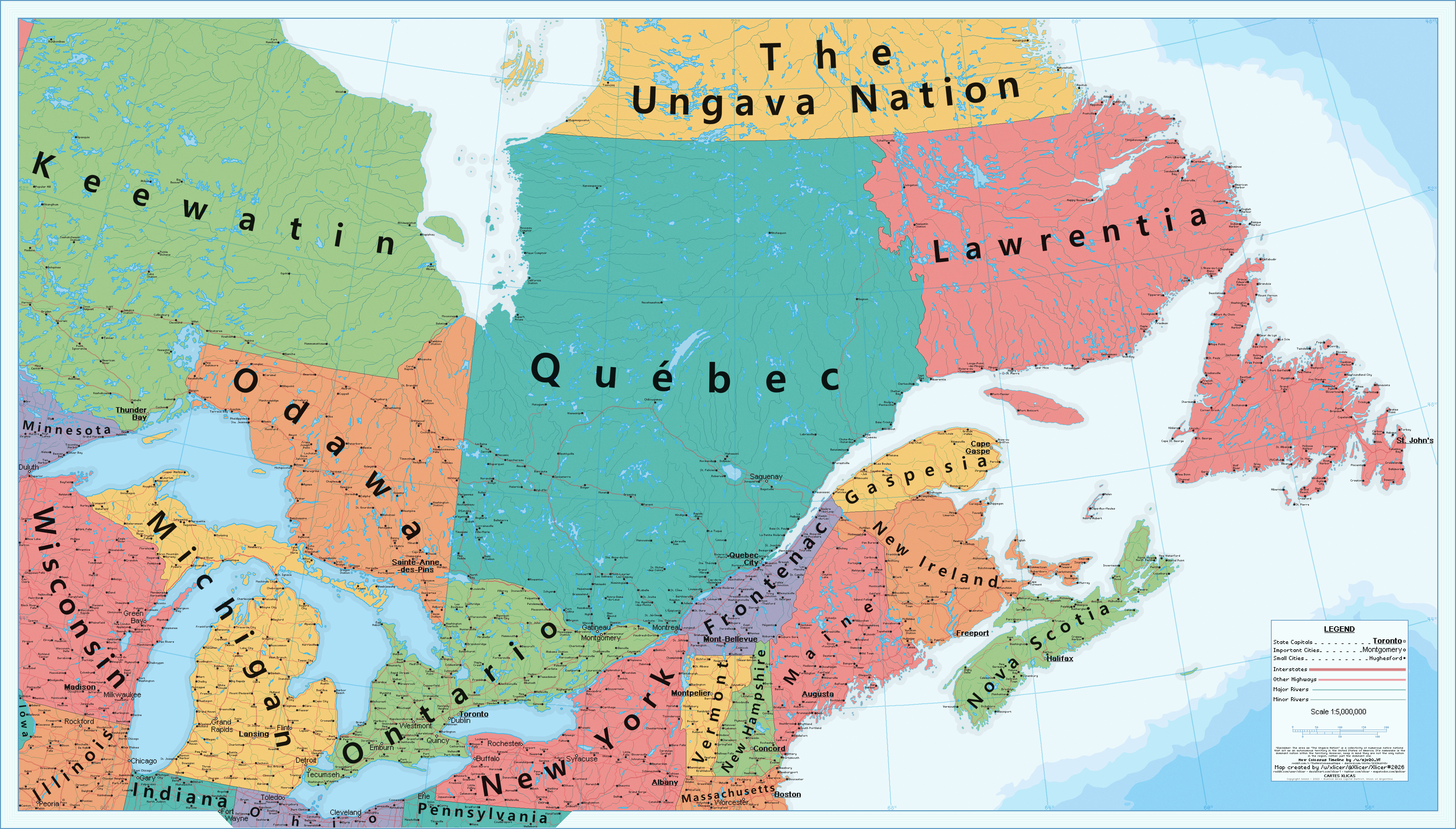
Great map. Though I am irritated thinking about what a small population Gaspesia would have. It would mke more sense to have Prince Edward Island as its own state at that pointWhat if the US annexed Canada after the war of Independence? - The East Canadian States as of 2023 - The New Colossus
DeviantArt Link
Hi alternatehistory.com. This is a map made for the one-year anniversary of the timeline "The New Colossus" made by reddit user and friend /u/ajw20_yt
This map focuses in on the Canadian states. Canada was annexed by the United States, not during 1812, but during the treaty of Paris in 1783. Nova Scotia and New Ireland were part of the 15 colonies, and a major part of this TL is focusing on the effects that these new states bring, such as more stripes and stars on all the flags, and free healthcare. After these states are admitted as free states, many southern politicians try harder at expanding, going for many areas of the Caribbean, such as in 1812 when America takes over Jamaica. You can see some of these alternate states in the northern areas of this map, with stations being named after them. Many cities around post-Canada also have Americanized names now.
As for post-Canada proper, Ontario is just like any other part of the great lakes. Toronto is Chicago's main rival, and is one of the larger cities that can be found there. Quebec still retained many French migrants and settlers as the years went on, and the culture, language, and rights of the French-Americans were protected from early on. Quebec stayed neutral in most American politics, but today still remains a large distinct cultural part of the United States. It's also worth mentioning that both Pierre Trudeau and Justin Trudeau serve as presidents of the United States, with Pierre Trudeau gifting America the aforementioned universal healthcare.
Thank you, and happy anniversary TNC. And I hope you all enjoy this map!
You are using an out of date browser. It may not display this or other websites correctly.
You should upgrade or use an alternative browser.
You should upgrade or use an alternative browser.
Map Thread XXI
- Thread starter fluttersky
- Start date
-
- Tags
- map map thread
- Status
- Not open for further replies.
Threadmarks
View all 131 threadmarks
Reader mode
Reader mode
Recent threadmarks
[50+ Likes] Sultanate of England, by Sārthākā Big Nations series, by Alex0505 A re-projection of Jean Lattre's 1762 world map, by Ashtagon [50+ Likes] The Russo-Ukrainian conflict in context, by NeonHydroxide Rose, Tulips, and Liberty, by Unkown00 Caliphate of Albion 1450, by Sārthākā 1932 Centauri-Human War, by Alex0505 Bharata is the World (part 3) by wildviper121First thanks, and there are slightly different settlement patterns that allows Gaspesia to have enough to be it’s own state. Also it has much different culture than Frontenac, so it didn’t make sense to combine the states.Great map. Though I am irritated thinking about what a small population Gaspesia would have. It would mke more sense to have Prince Edward Island as its own state at that point
Plus, this minimum population requirement for a state in the modern day is also much lower, with a state only needing about 300,000 to be a state. There are actually 935 house reps in this timeline, despite there only being an additional hundred million people. This was done in the timeline on purpose to allow for smaller states and more representation
Yeh I just have a knee-jerk dislike of small states in MegaUS settings, as in all of my own versions I try to break up and consolidate states to get them into roughly equivalent populations. Mainly because I like the concept of equal senatorial representations but obviously massive population differential can pose problems for that. But there's nothing inherently wrong with small states, they can have a charm all their own and allow the full sweep of cultures to be represented in their own unit.First thanks, and there are slightly different settlement patterns that allows Gaspesia to have enough to be it’s own state. Also it has much different culture than Frontenac, so it didn’t make sense to combine the states.
Plus, this minimum population requirement for a state in the modern day is also much lower, with a state only needing about 300,000 to be a state. There are actually 935 house reps in this timeline, despite there only being an additional hundred million people. This was done in the timeline on purpose to allow for smaller states and more representation
I would assume given how much bigger the House is the Senate has also been reformed ITTL?
Hardest I've laughed all day.Ok, idk why I went through with this.... I'm sorryspare me pls guys
Though I would like to see the Sultanate of Sus...
Good point, I didn't put as much thought into Europe as I should have. I assumed once the Wallies broke through the Atlantic wall it would be only a matter of time before Germany falls. At the same time I was probably too generous to how far the Soviets would get into Eastern Europe. I'll have to rethink about it.I agree with Wendell, it seems to me that soviets, aside of Berlin, get as much ground in Europe as OTL, while having harder time than OTL (two front war! complicated lend-lease...)
On the other hand, Wallies in Europe may have been handicaped by later USA involvement (no/postponed Torch? invasion to Sicily and Italy?), on the other hand, Britain probably would, at least between Barbarossa and Netherland Indias occupation, concentrate its resources and forces in Europe even more than OTL (can, without Americans, drive Axis out of Africa? if, than I can see some attempt in Mediterranean, most, probably invasion on some island, for the start... Crete? Sicily?)
Also, what would happend with Vichy France/French (north) Africa with no (or postponed) Torch?
After giving it some thought I've remade a few things to reflect what @Wendell and @xmoose said. The Soviets occupy less of eastern Europe. Poland is split east and west, Hungary is turned into a neutral nation, and Tito dies leaving pro-Soviet figures in charge which erupts into a short civil war following WW2 where Croatia breaks away and ends with Soviet intervention. Although the USSR controls less territory than OTL, it also has more control over the Communist bloc as there's no Mao or Tito that opposes them.

Last edited:
Not sure if this is the right place to post. If I'm (completely) off topic I apologize in advance. I recently read the newest version of Guns, Germs and Steel and that got me thinking of Chris Wayan's Jaredia (from the Planetocopia series). Jaredia's world spanning corridor/belt is tropical, while Diamond focuses on the potential of a massive temperate corridor/belt. I have a hunch that by placing the South Pole on Australia (poor marsupials) one might just get a world spanning interconnected temperate belt. Is anyone aware of site or a software tool that allows you to recenter the earth's poles? Thank you!
Sure! Here's two:Not sure if this is the right place to post. If I'm (completely) off topic I apologize in advance. I recently read the newest version of Guns, Germs and Steel and that got me thinking of Chris Wayan's Jaredia (from the Planetocopia series). Jaredia's world spanning corridor/belt is tropical, while Diamond focuses on the potential of a massive temperate corridor/belt. I have a hunch that by placing the South Pole on Australia (poor marsupials) one might just get a world spanning interconnected temperate belt. Is anyone aware of site or a software tool that allows you to recenter the earth's poles? Thank you!
NASA GISS: G.Projector — Map Projections
Alternative World Maps
See what world maps look like if the distortion is moved away from the Poles.
www.petermoor.nl
Hi guys, I'm trying to create maps, but I'm pretty bad at this. Can someone help me? sorry if this isn't the right place to post?
My main objective now is to discover how to add cities on my map, with the markers/dots that indicate cities. I'm using Microsoft Paint. i tried to ask on reddit, but no replies, and google doesn't show anything.
My main objective now is to discover how to add cities on my map, with the markers/dots that indicate cities. I'm using Microsoft Paint. i tried to ask on reddit, but no replies, and google doesn't show anything.
If you're new to this, first things first, get rid of paint and install paint.net instead. It's more convenient for layers and you can learn to use some plugins to help you get better, but still generally intuitive.
American Nightmare

it's 4AM and i don't have too much time to explain but its the result of successful Armada of 1779 invasion of Britain. Christiana is also known as California-Deseret.
Definitely more of an art project at this point.
it's 4AM and i don't have too much time to explain but its the result of successful Armada of 1779 invasion of Britain. Christiana is also known as California-Deseret.
Definitely more of an art project at this point.
Nice, nailed the old book styleAmerican Nightmare
it's 4AM and i don't have too much time to explain but its the result of successful Armada of 1779 invasion of Britain. Christiana is also known as California-Deseret.
Definitely more of an art project at this point.
Gagauzia is a republic in Russian Federation0/10 no Gagauzia
This was really helpful! Off to test my hypothesis.Sure! Here's two:
NASA GISS: G.Projector — Map Projections
www.giss.nasa.gov
Alternative World Maps
See what world maps look like if the distortion is moved away from the Poles.www.petermoor.nl
vgh...
Banned
Not sure if this is the right place to post. If I'm (completely) off topic I apologize in advance. I recently read the newest version of Guns, Germs and Steel and that got me thinking of Chris Wayan's Jaredia (from the Planetocopia series). Jaredia's world spanning corridor/belt is tropical, while Diamond focuses on the potential of a massive temperate corridor/belt. I have a hunch that by placing the South Pole on Australia (poor marsupials) one might just get a world spanning interconnected temperate belt. Is anyone aware of site or a software tool that allows you to recenter the earth's poles? Thank you!
A world like this? I like how the Pacific keeps its shape weirdly. The South Pole is at 20S 133E, which in real life is in the middle of nowhere in the Northern Territory, 500 km north of Alice Springs, 800km south of Darwin, and in between them longitude-wise.
Also makes you wonder about climate. I'm not an oceanographer, but can the deep trenches/gaps in the continental shelf around the Wallace line sustain a strong circumpolar current as exists around IRL Antarctica? That current is a big part of why Antarctica is so cold and plays a big part in Earth's climate. It seems perfectly possible based on this, assuming sea levels similar to real life's. Still, it's no Drake Passage. There doesn't look like there will be much glaciation in the northern hemisphere either (in my opinion just based on the lack of land near the north pole), and Australia has a smaller land area than Antarctica, so maybe sea levels might be a bit higher anyway guaranteeing a strait for a strong circumpolar current? Because I know the Indonesian continental shelf was exposed during our ice ages.
All in all it looks (in my opinion) like the world's climate characterisation is either going to be somewhere between "a bit more maritime and balmy" and "Pliocene".
Marsupials should be fine, since we know from genetic and biogeographical evidence that Australian marsupials crossed to Australia from South America via Antarctica in the early Cenozoic. Antarctica will almost certainly have Australian-like Marsupials living there if it doesn't freeze over. Honestly, looking at its geography here, I think it could have a bunch of unique species living there in the present day. The Drake Passage isolates it from the rest of the world even after South America gets a faunal interchange, it's like 1000 kilometres. It could even be another Australia, with the only native placentals being rodents, bats and marine mammals, just bigger, more mountainous and shifted a bit north.
Last edited:
vgh...
Banned
@SpanakoRyzo Thoughts on this? If you go with that South Pole arrangement, you're going to get North America positioned sideways and with the Mississippi and Hudson basins well into the temperate zone sitting at the same latitude besides each other. Chris Wayan's Planetcopia works usually involve him leaving the scars of glaciation (Great Lakes, Hudson Bay etc) in North America to some degree, claiming he does it because Americans he shows the globes to don't know geography (knowing his audience) and he doesn't want to get too speculative about the pre-ice geography of the area, but realistically is there any reason this huge basin shouldn't exist without glaciation wrecking it? It would be your worldbuilding project and I'm not an expert, but in my personal opinion there could be a North America with two very big and productive river basin regions positioned next to each other at the same latitude, which would be awesome for the spreading of crops and animals according to Jared Diamond. Maybe the Canadian Shield can get some good topsoil too, granted I don't know how much of the infertility of the Canadian Shield is due to climate/latitude and how much is due to its geology.
If I'm not making a really dumb mistake here and we're catching butterflies in a Wayan-esque fashion but still speculative biogeographical romantics, I figure the Earth's biosphere might be a tiny bit different from ours because of some... past trauma. Although Seapole did have the same issue addressed.
Last edited:
What's the Big Blue-y bits in the frontier? Can't quite tell.American Nightmare
it's 4AM and i don't have too much time to explain but its the result of successful Armada of 1779 invasion of Britain. Christiana is also known as California-Deseret.
Definitely more of an art project at this point.
Currently the main reason that drives the Circumpolar Current is wind. Antarctica is pretty round and between Cape Horn and the tip of the Antarctic Peninsula there is no land anywhere within that latitude. That means wind can blow unimpeded following the Earth's rotation while sucking in extra air due to the coriolis effect. A world like that one does not fit the criteria as the Indonesian islands and New Zealand would block the flow of water. Also, Australia having its mountains around (and only in a certain part) instead of across like in Antarctica would diminish the accumulation of snow, at least in Western Australia. Oh and during an ice age most of Indonesia would be a peninsula so no circumpolar current there, the cold waters would be directed upwards along Java and Sumatra, making them Patagonia analogues, except a tad colder due to latitude.I'm not an oceanographer, but can the deep trenches/gaps in the continental shelf around the Wallace line sustain a strong circumpolar current as exists around IRL Antarctica?
Part of the reason why there is ice over the north pole is due to it being an almost closed off sea and being less saline than any of the other oceans, so the water can freeze at a higher temperature. With landmasses further south the continentality effect is mostly gone so temperatures in winter should be higher, leading to less ice. The Amazon would make a great Siberia analogue here, with its north-south plain and a big system of rivers. The Amazon could be dammed by ice during the ice age and create a huge lake (there's your Hudson Bay analog btw). This world also has more land on equatorial latitudes, which contributes to cooling the planet by increasing albedo. So maybe all of this cancels out, who knows, but I still bet on a warmer world.There doesn't look like there will be much glaciation in the northern hemisphere either
It's still a large outcrop of precambrian igneous rock, you aren't going very far with that even in moderate temperatures. However, no glaciation also means plants have time to break down the rock unimpeded, and no glaciers means no soil destruction either. Still not the best farmland. Plus in this configuration it would be exposed to masses of cold air coming from the pole in winter, albeit not as severely as Siberia.Maybe the Canadian Shield can get some good topsoil too,
Threadmarks
View all 131 threadmarks
Reader mode
Reader mode
Recent threadmarks
[50+ Likes] Sultanate of England, by Sārthākā Big Nations series, by Alex0505 A re-projection of Jean Lattre's 1762 world map, by Ashtagon [50+ Likes] The Russo-Ukrainian conflict in context, by NeonHydroxide Rose, Tulips, and Liberty, by Unkown00 Caliphate of Albion 1450, by Sārthākā 1932 Centauri-Human War, by Alex0505 Bharata is the World (part 3) by wildviper121- Status
- Not open for further replies.
Share: