I mean, its still leagues better than the OTL flag.Everything is amazing... except that Canadian flag 😭
You are using an out of date browser. It may not display this or other websites correctly.
You should upgrade or use an alternative browser.
You should upgrade or use an alternative browser.
Map Thread XXI
- Thread starter fluttersky
- Start date
-
- Tags
- map map thread
- Status
- Not open for further replies.
Threadmarks
View all 131 threadmarks
Reader mode
Reader mode
Recent threadmarks
[50+ Likes] Sultanate of England, by Sārthākā Big Nations series, by Alex0505 A re-projection of Jean Lattre's 1762 world map, by Ashtagon [50+ Likes] The Russo-Ukrainian conflict in context, by NeonHydroxide Rose, Tulips, and Liberty, by Unkown00 Caliphate of Albion 1450, by Sārthākā 1932 Centauri-Human War, by Alex0505 Bharata is the World (part 3) by wildviper121You can go with obvious Napoleon, but theres the same problem I guessA bit bogged down right now, I'm afraid. It's France - I'm having trouble developing a "more successful revolutionary France wank" which is further complicated by the fact that i already sort of did it with the Commutate Globale scenario I did a few months ago. Similarly, my Royal France wank is compromised by already having done a "France wins the war of the Spanish succession wank" which makes me want to try a different route.

About Charlemagne mentioned - I think even Merovingians were doing quite well in one moment
OR you can do (high) medieval France (13th century? at that time, Anjou and other branches of Capetian dynasty rule in like half of Europe, a bit earlier they try to conquer England etc.)
Francis I. was already mentioned, and Louis XIV. you already did (Richelieu would be too close I assume...) what about early revolution (there was some sort of hugenot plot in half of 17th century to turn France into Swiss-styled confederacy)... or get rid of revolution and turn France peacefully into stable, reformed constitutional monarchy (not sure how much potenciall for wank)...
My favourite would be 3rd empire (there were many attempts and project of Napoleon III.)
Or you can wank 3rd republic colonial empire or even attempt something around world war I (probably need to nerf somehow Germany, UK and USA or Russia though)
EDIT: What about gallic-centered Roman empire or even Gauls? (even if I am personally usually not a big fan of "too early" PoDs)
FireCrispyHistory
Banned
The hell? Is that Connecticut having an exclave west of Wyoming (Despite the fact that PA's name means Penn's Woods, referencing the fact that the area was gifted to William Penn. Why would they change it to Wyoming?)View attachment 787326
The United States of America, as of 1792, and the second presidential election in the country's history.
I'm thinking of having George Clinton win the vice presidential role to kick off this timeline's variations from our history, if the colonial names haven't done so already.
Any ideas for succeeding presidents and potential divisions of the still-to-come Louisiana Purchase?
1. Connecticut historically claimed that land and only gave it up in exchange for subsumption of its debts by the federal government. Virginia once claimed the entirety of the Northwest Territories, after all. Most of the colonies were initially granted “all land between your north and south borders, all the way to the pacific” in their royal charters.The hell? Is that Connecticut having an exclave west of Wyoming (Despite the fact that PA's name means Penn's Woods, referencing the fact that the area was gifted to William Penn. Why would they change it to Wyoming?)
2. OTL Wyoming is named after the region of Pennsylvania.
FireCrispyHistory
Banned
Yes, but you don't see Germany ever being called Frankfurt. You don't see Italy ever being called Palermo. You don't see America ever being called Minnesota. Why should a small borough cause a complete name change?2. OTL Wyoming is named after the region of Pennsylvania.
The same reason that all state/place names have always been up in the air. There were sometimes half a dozen potential state names before a territory organized itself. This is alternate history. Germany isn’t called Frankfurt because it isn’t. The POD here is clearly early enough that Plymouth colony survived, so there’s plenty that can change.Yes, but you don't see Germany ever being called Frankfurt. You don't see Italy ever being called Palermo. You don't see America ever being called Minnesota. Why should a small borough cause a complete name change?
u wotI mean, its still leagues better than the OTL flag.
Map of Middle Earth in the Late Fourth Age, just before the crises that would beset the Reunited Kingdom on all sides.
Incomplete. Future updates will not be posted here until completion.

Incomplete. Future updates will not be posted here until completion.
Planet of Hats
Donor
They chose that flag as a symbol of the country's Loyalist roots!Everything is amazing... except that Canadian flag 😭
What is that and why
Also, does the lack of Manitoba mean no Red River Rebellion? No Louis Riel??
Louis Riel was born more than 30 years after the POD, so he's unlikely to be around here. There were certainly Métis resisting rule from Cobourg, but things played out Ambiguously Differently. The province of Saugegan has a certain degree of influence from that culture, at least.
How dare you disrespect the glorious maple leaf!I mean, its still leagues better than the OTL flag.
FireCrispyHistory
Banned
So, this project took me a while, but I went to mapchart and tried to recreate the HoI4 map. Of course, it is me and i forgot about it for a few months, and then noticed it. Also, the map got updated (Thank you, BBA!), so I had to re-do it. Anyway, since the photo turned out too large, I instead decided to take a photo of each continent and post them separately. Here you go. If you have any thoughts, do not hesitate to share them with me.


Note: That Blue in Brazil is an error. Please do not mind it.


Remember, the blue is meant to be the same, just an error in the creation of the map.


Remember, don't hesitate to share any thoughts. ANY thoughts.

This is the full map, so you can see why i wouldnt want to send this one. The borders...
America
Canada
Soviet Union
Britain
Mexico
Guatemala
Cuba
El Salvador
Haiti
Dominican Republic
Honduras
Nicaragua
Costa Rica
Panama
Netherlands
France
Denmark
Venezuela
Colombia
Canada
Soviet Union
Britain
Mexico
Guatemala
Cuba
El Salvador
Haiti
Dominican Republic
Honduras
Nicaragua
Costa Rica
Panama
Netherlands
France
Denmark
Venezuela
Colombia
Note: That Blue in Brazil is an error. Please do not mind it.
Nicaragua
Costa Rica
Panama
America
Colombia
Venezuela
Peru
Netherlands
Ecuador
Chile
Argentina
France
Uruguay
Bolivia
Paraguay
Brazil
Spain
Portugal
Italy
Liberia
South Africa
Britain
Costa Rica
Panama
America
Colombia
Venezuela
Peru
Netherlands
Ecuador
Chile
Argentina
France
Uruguay
Bolivia
Paraguay
Brazil
Spain
Portugal
Italy
Liberia
South Africa
Britain
Britain
Ireland
Portugal
France
Spain
Italy
Belgium
Netherlands
Luxembourg
Germany
Switzerland
Austria
Yugoslavia
Albania
Greece
Bulgaria
Romania
Czechoslovakia
Poland
Hungary
Lithuania
Latvia
Estonia
Soviet Union
Turkey
Iraq
Iran
Norway
Denmark
Sweden
Finland
Ireland
Portugal
France
Spain
Italy
Belgium
Netherlands
Luxembourg
Germany
Switzerland
Austria
Yugoslavia
Albania
Greece
Bulgaria
Romania
Czechoslovakia
Poland
Hungary
Lithuania
Latvia
Estonia
Soviet Union
Turkey
Iraq
Iran
Norway
Denmark
Sweden
Finland
Remember, the blue is meant to be the same, just an error in the creation of the map.
Brazil
Spain
Portugal
Liberia
Ethiopia
Aussa
South Africa
France
Britain
Belgium
Italy
Greece
Turkey
Saudi Arabia
Oman
Yemen
Iraq
Iran
Soviet Union
Brazil
Afghanistan
British Raj
Spain
Portugal
Liberia
Ethiopia
Aussa
South Africa
France
Britain
Belgium
Italy
Greece
Turkey
Saudi Arabia
Oman
Yemen
Iraq
Iran
Soviet Union
Brazil
Afghanistan
British Raj
Estonia
Latia
Lithuania
Sweden
Finland
Norway
Germany
Poland
Czechoslovakia
Hungary
Yugoslavia
Albania
Italy
France
Aussa
Ethiopia
Britain
British Raj
Greece
Romania
Bulgaria
Turkey
Saudi Arabia
Yemen
Oman
Iraq
Iran
Soviet Union
Afghanistan
Japan
Manchukuo
Mengkukuo
Shanxi
Guangxi Clique
Yunnan
Tibet
Tannu Tuva
Mongolia
Sinkiang
Xibei San Ma
Communist China
China
British Malaya
Portugal
Siam
Philippines
United States
Nepal
Bhutan
British Raj
Siam
France
United States
Britain
Dutch East Indies
British Malaya
Portugal
Australia
New Zealand
Japan
Siam
France
United States
Britain
Dutch East Indies
British Malaya
Portugal
Australia
New Zealand
Japan
Remember, don't hesitate to share any thoughts. ANY thoughts.
This is the full map, so you can see why i wouldnt want to send this one. The borders...
Last edited:
EPICUpdate:

Now with atlas and road signs. The highway network stops at the Mexican border because I'd go absolutely insane trying to cram highway indicators into the density madness that is the urban environs of Ciudad Mexico. The Laurentian network was hard enough, thank you.
A lot of island names in the Arctic are different because the royal family went in another direction. Sorry, Queen Vicky. Better luck OTL.
P.S.: Flags are either OTL variants or stuff I put together solo.
things that seem odd:
Why is there no trans-canada highway across Newfoundland? (there is OTL)
Could be put down to the small costal province being ignored TTL relative to the great lakes and northern plaines interior
American virgin islands (1917 purchase) don't seem like such a fit for the alt-usa
Basically asking if these are deliberate decisions or OTL leftovers in the map, and if deliberate why
Planet of Hats
Donor
Newfoundland has a provincial highway but I probably forgot to draw it in because I'm a goober.EPIC
things that seem odd:
Why is there no trans-canada highway across Newfoundland? (there is OTL)
Could be put down to the small costal province being ignored TTL relative to the great lakes and northern plaines interior
American virgin islands (1917 purchase) don't seem like such a fit for the alt-usa
Basically asking if these are deliberate decisions or OTL leftovers in the map, and if deliberate why
The fact that the US got pushed around a lot didn't preclude colonial ambitions. The former Danish Virgin Islands are an American vanity project, mostly. It's the Slavocracy going "Look at us! We can colony too!"
You have Poland wrong. That far south-east province should be Soviet.So, this project took me a while, but I went to mapchart and tried to recreate the HoI4 map. Of course, it is me and i forgot about it for a few months, and then noticed it. Also, the map got updated (Thank you, BBA!), so I had to re-do it. Anyway, since the photo turned out too large, I instead decided to take a photo of each continent and post them separately. Here you go. If you have any thoughts, do not hesitate to share them with me.
View attachment 787450
America
Canada
Soviet Union
Britain
Mexico
Guatemala
Cuba
El Salvador
Haiti
Dominican Republic
Honduras
Nicaragua
Costa Rica
Panama
Netherlands
France
Denmark
Venezuela
Colombia
View attachment 787451
Note: That Blue in Brazil is an error. Please do not mind it.
Nicaragua
Costa Rica
Panama
America
Colombia
Venezuela
Peru
Netherlands
Ecuador
Chile
Argentina
France
Uruguay
Bolivia
Paraguay
Brazil
Spain
Portugal
Italy
Liberia
South Africa
Britain
View attachment 787452
Britain
Ireland
Portugal
France
Spain
Italy
Belgium
Netherlands
Luxembourg
Germany
Switzerland
Austria
Yugoslavia
Albania
Greece
Bulgaria
Romania
Czechoslovakia
Poland
Hungary
Lithuania
Latvia
Estonia
Soviet Union
Turkey
Iraq
Iran
Norway
Denmark
Sweden
Finland
View attachment 787453
Remember, the blue is meant to be the same, just an error in the creation of the map.
Brazil
Spain
Portugal
Liberia
Ethiopia
Aussa
South Africa
France
Britain
Belgium
Italy
Greece
Turkey
Saudi Arabia
Oman
Yemen
Iraq
Iran
Soviet Union
Brazil
Afghanistan
British Raj
View attachment 787454
Estonia
Latia
Lithuania
Sweden
Finland
Norway
Germany
Poland
Czechoslovakia
Hungary
Yugoslavia
Albania
Italy
France
Aussa
Ethiopia
Britain
British Raj
Greece
Romania
Bulgaria
Turkey
Saudi Arabia
Yemen
Oman
Iraq
Iran
Soviet Union
Afghanistan
Japan
Manchukuo
Mengkukuo
Shanxi
Guangxi Clique
Yunnan
Tibet
Tannu Tuva
Mongolia
Sinkiang
Xibei San Ma
Communist China
China
British Malaya
Portugal
Siam
Philippines
United States
Nepal
Bhutan
View attachment 787456
British Raj
Siam
France
United States
Britain
Dutch East Indies
British Malaya
Portugal
Australia
New Zealand
Japan
Remember, don't hesitate to share any thoughts. ANY thoughts.View attachment 787457
This is the full map, so you can see why i wouldnt want to send this one. The borders...
FireCrispyHistory
Banned
Thanks for informing me, despite being a magnet from Poland who would probably be proud to have it be bigger than normal.You have Poland wrong. That far south-east province should be Soviet.
Another entry into my fantasy setting, this time explaining the rise and fall of a religion, presented as pages 112-113 of a fictional history textbook
If anyone is wondering what the poem says:
tarytaru luhāu komō
ceūŋo ñy verrī hū u'akurai
jījī ñy liurau ȳrē komō
Sāvēla dēno obu'a kireu
In english:
broken branches
fallen from a mighty tree
glisten with fruit
the earth-god reclaims them
Last edited:
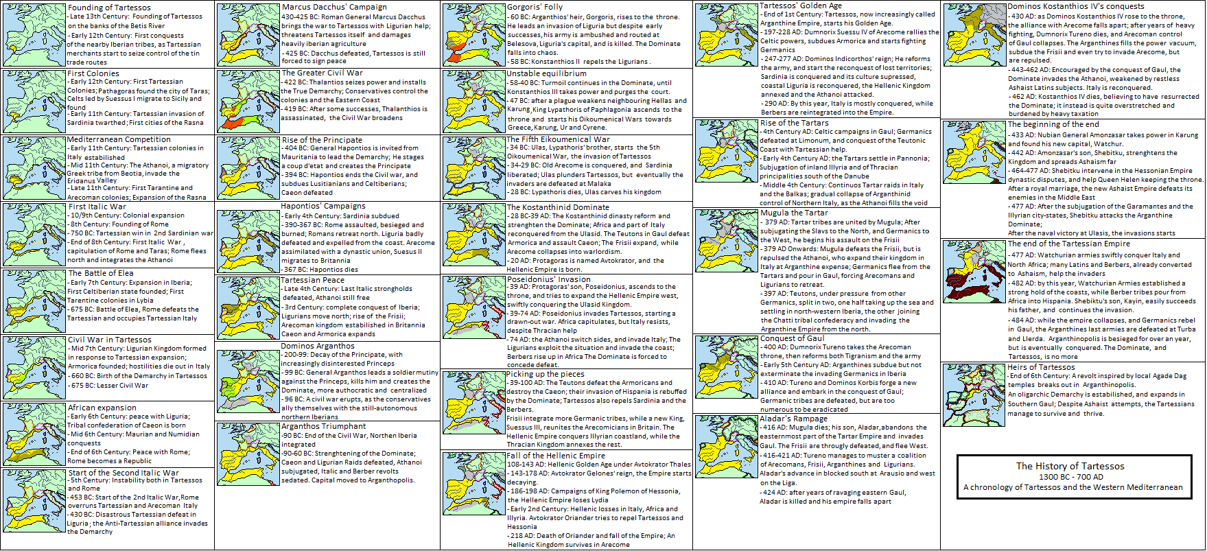
Hello everybody!
This is my second map; It’s a spin-off of my first map, in wich I depicted the world of a collaborative alternate history map-game hosted in Civ Fanatics Forum many years ago, called AFSNES (Advance Fresh Start NES).
That map depicted a particular moment in that history, TTL’s 700 AD, after the end of the equivalent of the Dark Age; while I tried to give a very broad impression of that scenario’s rich lore through nations’ description and notes, many interesting moments and polities were lost, or not nearly visible enough.
One of those lost histories is the Empire of Tartessos.
Once TTL’s mightiest empire in Europe, Tartessos, a celtic/iberian city founded in late 13th Century BC, in its almost one millennium and half of history, rose from southern Iberia to Western Mediterranean hegemony, passing though many crises, barbarian assaults, civil wars, defeating stubborn enemies (among them Rome itself), and surviving against foreign invasions.
The history of Tartessos is the history of TTL’s Western Europe and Western Mediterranean; it’s the history of Rome, of the Celtic people of Arecome, of the Greek poleis of Central Mediterranean, of the Athanoi of the Eridanus Valley, of the stubborn people of Liguria, of the Berbers in North Africa, of the Celts in Gaul and their struggle against invading Germanic people, it the history of the great empires of the Near East, like Paphlagonia, the Tartars, and ultimately the greatest, the Watchurian Empire.
I tried to chronicle the ebb and flow of Tartessos and its many neighbours through a series of localized maps, highlighting in each the changes of its protagonist’s borders, and giving a brief chronological description.
I hope that the result will be interesting enough; In the future, I might do similar series for other civilizations, or more detailed maps of singular empires.
As I already detailed in my previous map write-up, do mind that the scenario depicted is not my creation, and I had a minimal contribution in its creation (I was one of the many players involved);
The main “culprit” was the moderator of AFSNES, Das, that coordinated the player efforts into as realistic as possible way; the other principal creative force behind this timeline was Insane-Panda, the players actually behind Tartessos.
The other players involved in this part of the world will be detailed in the Credits.
Pleas enjoy my new map! Any feedback is appreciated.
CREDITS
Das – Moderator, curator of the whole scenario
Kal’thzar – Nubia, Ashaism, Watchur and its successor states, Tarekid Amsurate
~ Darkening~ - Tihuanaco
JoesfStalinator – Arecoman Celts, Caerix and Tigranism
Insane-Panda – Tartessos
Toltec – Paphlagonia
Dachs – Latins, Rome, Thuringia
Thlayli – Parthenian Republic, Greek poleis, Hellenic Empire, Corcyran League
Niklas – Ur and its various empires, Agade Dag
Nuka-Sama – Racadonia
Littleboots – Athanoi
Shortguy – Mitanni, Frisians
Neverwonagame3 – Karung and Karrism
LightFang- Sardinia
Daftpanzer – Odrysa and Thracians
Altair – Liguria
erez87 – Caeon
The13thRonin – Hessonia, Hessonian Greeks and Delphian Empire
j_eps – D’mt, Axum, Liths
FireCrispyHistory
Banned
Uh...this is not a mapThe Not-So American Century
Index
-------
List of largest New South Welsh companies (by revenue)
View attachment 787890
I don't know exactly where to post this, but as maps are involved, I put it here in the general map thread. And the creation is not mine (links and credit are below).
I stumbled on this fictional nation while looking up things for Football Manager 22. A user has created a whole fictional nation, namely (the Kingdom of) Morgsthia. That it is supposed to be a constitutional monarchy becomes clear from the text below:
(by Ozbay in a post further down):
What do you think, mainly the football types around here like @QTXAdsy , @NTF aka Seb , @Dom , @Fletch et al.
But of course, we can also create other types of lore around Morgsthia.
By the way I somehow thought of a variant on Doggerland...
The link, credit goes to the user "Ozbay".
The two "main" maps:
https://content.invisioncic.com/Msi.../Map.png.72aadb99eba01447b0b98e74604dfaba.png

Hi, and sorry about the late reply.
What I think? Be more specific, please. I'm not sure I understand entirely what you wanna know.
1. That's not the whole Gran Chaco region, in the OTL Paraguay-Bolivia border, some of the Chaco is Bolivian soil.Thank you for the constructive feedback!
Taking each issue at a time:
1. re:Chaco War: the war is primarily fought over the Gran Chaco region, hence why I gave it entirely to Argentina in a victory scenario, plus I figured they would push for more in treaty negotiations. Do you have another suggestion for the post-war Argentina-Bolivia birder? I am definitely open to revising the final borders for sure!
2. re:Brazil: My reasoning for splitting Brazil was more as just a concession to the frustration that the war had been going on for almost a decade, with neither side close to victory. Therefore, the sides decide to make an uneasy peace and take a break to regroup, creating those borders. Later in the nineteenth century, I imagine the war will resume but for the 1880s an uneasy peace with those borders is created. Is there a better way to show that on the map, or do I just need to do a better job explaining that in my narrative when I post about it?
2. Yes, for example, you may show that both halves claim the whole rest of Brazil, just like the Republic of China and the Popular Republic of China claim the whole of China; and North Korea and South Korea both claim the whole of Korea.
Threadmarks
View all 131 threadmarks
Reader mode
Reader mode
Recent threadmarks
[50+ Likes] Sultanate of England, by Sārthākā Big Nations series, by Alex0505 A re-projection of Jean Lattre's 1762 world map, by Ashtagon [50+ Likes] The Russo-Ukrainian conflict in context, by NeonHydroxide Rose, Tulips, and Liberty, by Unkown00 Caliphate of Albion 1450, by Sārthākā 1932 Centauri-Human War, by Alex0505 Bharata is the World (part 3) by wildviper121- Status
- Not open for further replies.
Share: