Map Thread XX

Status
Not open for further replies.
The Roman and Parthian Empires, c. 300 CE
Fantastic, fantastic work. What a great way to do a Rome-wank by not so much wanking Rome as just screwing up its rivals, and not even in an exceedingly obvious way since I assume all the successor Parthian kingdoms can balance each other out, and the client kingdoms being developed in the north in Germania is a GREAT idea.

Minor detail comments and questions: 1) I notice Petraea has the fat border I see it sometimes with, a nice subtle indicator of Roman power, 2) what is that border for Roman Dacia? It seems a bit bigger than the usual one post-117-270 AD, and 3) what is the province north of Moesia Inferior and west of the Bosporan Kingdom?
 
Ooh, I'd like to know what is what.
I only have a few nations swapping (with the rest just being as they did their thing or whatever):
China/Zhanguo (lit. warring states, as opposed to Zhongguo which means central state) and Western Europe/the 'Holy Empire of the Germano-Roman (Europe's cultures are... odd to say the least) People'/Nishitikoku/Visigothia are swapped, Japan and Korea are the equivalents of England and France respectivally, and the Hindustan is a semi-Ottoman stand in. Some other things, like the greeks losing greece, but keeping anatolia (and the islands), and the Vikings losing jutland, but keeping Danelaw are just things I'd think would be cool to be in it (and possibly somewhat realistic).

Fascinating. Who hath colonized what?
The west coast nation (Kibonoku) was colonized mainly by Japan, but the province around washington/the puget sound was colonized by the Koreans.
The Colombia nation (Junanua) was colonized by Korea
the colonies in eastern south america was colonized by the Mali Empire, with the northern one (Kuramana) holding the exiled monarchy, and the southern one (Baaradan) being ttl's version of communism (with the smaller one being a full on ancom free state)
The Canada nation is just your standard Vinland, although with a 90% increase of liking the natives (due to the Haudenosaunee Confederation threatening them both)
The Australia nations were colonized by Japan (the bigger one, Sausurando) and the other one was colonized by Karnataka/Kannada (Sautlyand)
What is the general gist of things ITTL. What are some of the important nations?
The main nations (not in any particular order) are Nishitikoku, Japan, Korea, Nusantara (mainly hindu, and is the Dutch to Japan's Britain), the 'People's Tyranny of Greece' (alt communism), the sultanate of Cairo, Hindustan (a bit ironic, all things considering), the Great horde (central asian nation), the Vikings/Nordland, and Kibonoku.
 
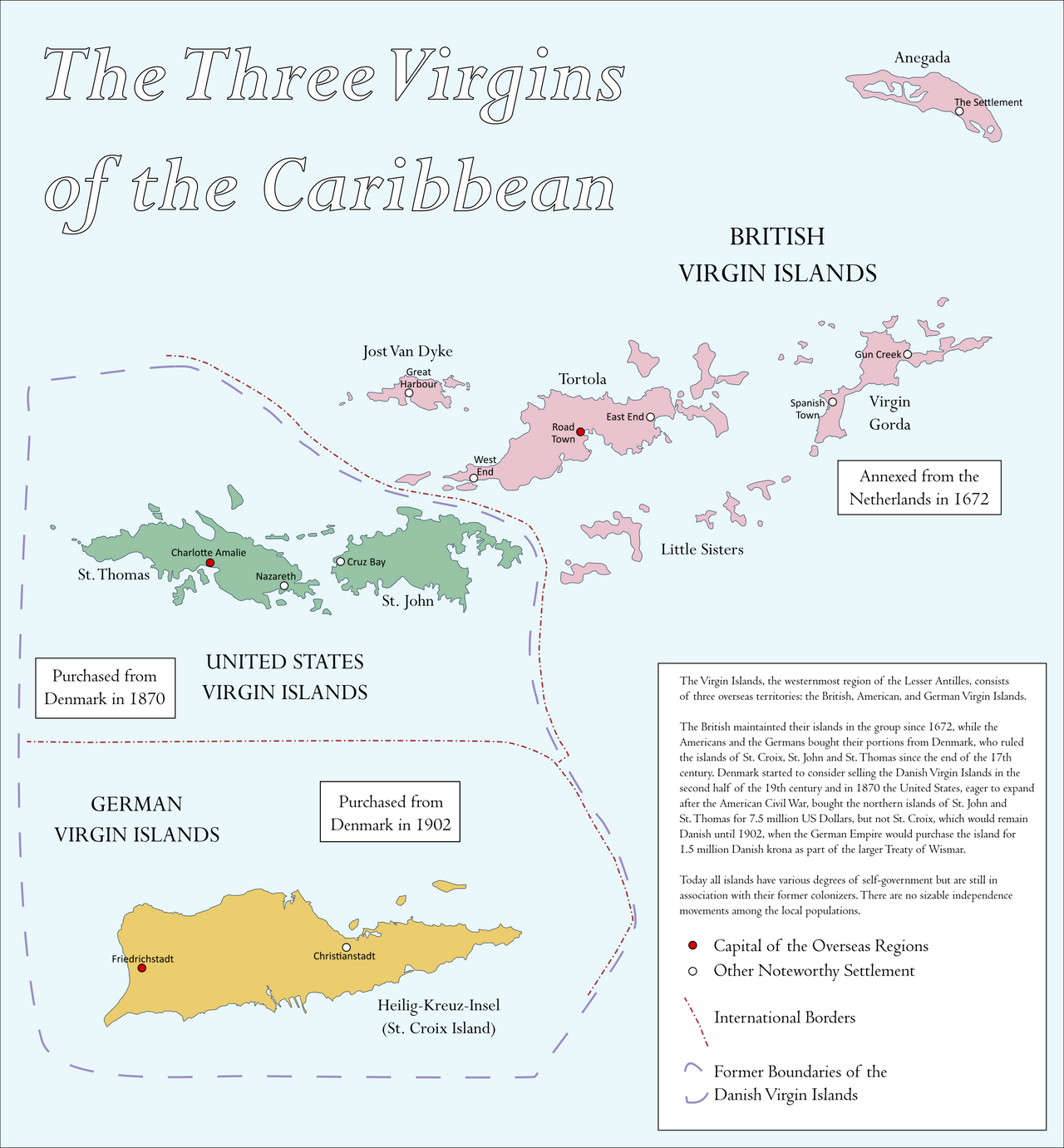
the_three_virgins_of_the_caribbean_by_federalrepublic_den20e5-fullview.png


Just crossposting my entry or round #238 of the Map of the Fortnight Contest. No real description necessary, it was just a quick map I made during the course of a day to get something done for it.
 
Sausurando

Does not really work as the name of a Japanese colony as the name is entirely English loanwords.

South in Japanese is Minami or Nan (2nd one actually from Chinese).
Not sure about the correct term for "land" in the context of territory/region tho.
 
Does not really work as the name of a Japanese colony as the name is entirely English loanwords.

South in Japanese is Minami or Nan (2nd one actually from Chinese).
Not sure about the correct term for "land" in the context of territory/region tho.
Gōshū (豪州, "great state") is the oldest name that Japan has for Australia.
 
The Louisville, Peoria & Minneapolis was a Class I railroad in the Midwestern United States between 1960 and 1982. It was formed from the merger of three railroads, the Minneapolis & St. Louis, the Toldeo, Peoria & Western, and the Chicago, Indianapolis & Louisville (better known as the Monon). Known as the East-West Short Route, the LP&M was convinced in the late 50s by M&StL Chairmen Benjamin W. Heineman as a way for freight traffic to bypass the congested Chicago region. Upon the passing of the Staggers Rail Act of 1980, LP&W management recognized that it could not survive deregulation. The era of strict railroad regulation had allowed many bridge lines to survive, but in the now the future of the railroad under deregulation seemed bleak. In 1982, the LP&W was sold to a consortium of the Southern Railway, Santa Fe, Burlington Northern, and Illinois Central Gulf, who split the railroad between them.

This was an actual proposal by M&StL Chairman Heineman in the mid to late 50s. Unfortunately, his tactics in trying to acquire the T&PW and the MON not only angered many of their stockholders but the ATSF and PRR, who proceed to jointly acquire the TP&W, dooming Heineman's plan. The M&StL was merged into the Chicago & North Western (now Union Pacific) in 1960 while the MON was acquired by Louisville & Nashville (now CSX) in 1971. As for the TP&W, Conrail sold its stock to the ATSF in 1979, with the railroad being merged into its parent road in 1983. The ATSF sold the former TP&W to a new company (with the same name) in 1989. It's still around today.
Louisville, Peoria & Minneapolis Smol Size.png
 
What was the request, if you don't mind me asking?

To quote:

I’d like to request a map of Europe in year 1894.

Essential:
● State named “Patrimonium of Italy”*, claiming OTL Italy, Tirol, Provance, southern Switzerland, Adriatic coast, Constantinople, Palestine (not sure about the name, but including Jerusalem, Sinai and Suez region), Tripolitania, Cyreneica, Crete, Corsica, Cyprus, Malta and Gibraltar. It might optionally include territories in Greece , Ionian Coast or African Coast. It may not include Egypt, Sardinia or Tunis.
● State claiming OTL central and northern Russia and Scandinavia up to Hudiksvall-Steinkjer line. This is either Finn-dominated country or Scandinav-Russian meld. The name of this state is up to you, but some variation of Varangia would probably be most appropriate.
● Navarre, that controls Sardinia, but is not a “copy-paste” Aragon.
● Sweden, that controls OTL southern Sweden, and Danish great belt islands.
● Norway, that controls OTL southern Norway, and Alborg region.
● Poland-Something. ;)
● Lorraine.
● No independent Bohemia, or any sort of Czech nation for that matter.
● No independent Ireland, or any sort of Celtic nation for that matter.
● No single state dominating British Isles.
● Holstein, that is either Polish or Lorrainian.

Optional:
● If you make this map POD specific, that POD should be as late in history as possible.
● Trøndelag, Livonia, Ingria, and/or OTL northern Poland – being some sort of satellite states or protectorates of this Norse-Russian state.
● “Teutonic Federation”* as presented here: https://www.alternatehistory.com/discussion/showpost.php?p=838433&postcount=130
● State that controls Brittany should have some foothold in Ireland.
● Important cities marked and labeled.
● All states labeled.
● No internal borders.
 
Does not really work as the name of a Japanese colony as the name is entirely English loanwords.

South in Japanese is Minami or Nan (2nd one actually from Chinese).
Not sure about the correct term for "land" in the context of territory/region tho.
I barely know any japanese, so I just used google translate, and tried to use word corruption to my advantage
 
A cleaner but less detailed version of an earlier map I made:

Most Recent Foreign Sovereignty of Every Country

With each country being colored as a whole based on the plurality of the territories owned by other countries whose capitals resided outside the modern borders.

Example:

Spain has territory, such as Barcelona, which was most recently French. However Morocco has the most ownership, due to the Moorish era, so it takes the whole. Separate countries such as Grenada or Aragon had capitals inside modern Spain, so they never count as "foreign".

Also, sovereignty is counted as legal ownership, so autonomous colonies/protectorates/vassals count, but temporary military control does not.

My two personal favorite tidbits:
Denmark, Sweden, and Norway play musical chairs.
Japan has never been colonized, so American Okinawa takes the whole on less than 1%

never-base3b.png
 
Denmark, Sweden, and Norway play musical chairs.
I take it the logic here is
-all of Norway is most recently Swedish, due to the nineteenth-century personal union
-all of Sweden is most recently Danish, in part due to the Kalmar Union and in part due to later gains from Denmark-Norway
-Denmark proper is uncolonized, but the Atlantic islands are most recently Norwegian (counting back to the fourteenth century)

I'm a little surprised that Britain won out in the United States. We think so much about how big the western lands are for their population that it's easy to forget the East is big too.
 
I'm a little surprised that Britain won out in the United States. We think so much about how big the western lands are for their population that it's easy to forget the East is big too.

I'm not when you think about it.

East of Mississippi (other than Florida) Britain, of course, Pacific Northwest was also arguably British (it was disputed but I think if you are going to say sovereignty where the capital is not in US Britain is best choice). Areas gained from changing rivershed borders to straight line with Canada are also British.
Louisiana Purchase area is French.
Southwest is Mexican.

Even if Southwest could beat out the East I would say the addition of Pacific Northwest handles it.
 
I'm a little surprised that Britain won out in the United States. We think so much about how big the western lands are for their population that it's easy to forget the East is big too.


Even if Southwest could beat out the East I would say the addition of Pacific Northwest handles it.

French louisiana is 1-2% larger or smaller than everything east of the mississippi, depending on how you measure it. So Oregon is quite the tiebreaker.
 
1900 map of My take on Southern Victory or More accurately Anglo-French intervention in US Civil war.

The intervention is the result of catastrophic American diplomatic blunders and all around military miscalculation. This obviously becomes a Gigantic War.

Some changes are just the result of random butteries/dice rolls. One bigger thing to note is an 1890's war between Russia, China and Japan which ends more or less is a status quo peace after British intervention. China got some good dice rolls and comes out of the war quite well, with some successful reforms after the war too.

Overall both Britain and the US end up much more militaristic and significantly larger standing armies than OTL.

I am thinking of making a prettier 1950's/60's style regional map set in this world and I would love ideas for what I time/area to cover.

World 1900.
Southern_Victory.png

Reading Guide
Thirsd_American_Republic_World_map_how_to_read.jpg
 
A cleaner but less detailed version of an earlier map I made:

Most Recent Foreign Sovereignty of Every Country

With each country being colored as a whole based on the plurality of the territories owned by other countries whose capitals resided outside the modern borders.

Example:

Spain has territory, such as Barcelona, which was most recently French. However Morocco has the most ownership, due to the Moorish era, so it takes the whole. Separate countries such as Grenada or Aragon had capitals inside modern Spain, so they never count as "foreign".

Also, sovereignty is counted as legal ownership, so autonomous colonies/protectorates/vassals count, but temporary military control does not.

My two personal favorite tidbits:
Denmark, Sweden, and Norway play musical chairs.
Japan has never been colonized, so American Okinawa takes the whole on less than 1%

View attachment 665354
I mean, Japan was technically colonized by the Yayoi people who migrated from the Asian mainland around two thousand years ago, largely displacing the original Jōmon people.
 
I mean, Japan was technically colonized by the Yayoi people who migrated from the Asian mainland around two thousand years ago, largely displacing the original Jōmon people.
I didn't mean colonization in the sense of people immigrating. Neither of those groups had states until centuries later, and those states, the Yamato polities, were undoubtedly "native" to Japan and not foreign. Ever since the establishment of Japanese formal government, no foreign states have claimed territory on modern japan, with the exception of Okinawa.
 
I'm not when you think about it.

East of Mississippi (other than Florida) Britain, of course, Pacific Northwest was also arguably British (it was disputed but I think if you are going to say sovereignty where the capital is not in US Britain is best choice). Areas gained from changing rivershed borders to straight line with Canada are also British.
Louisiana Purchase area is French.
Southwest is Mexican.

Even if Southwest could beat out the East I would say the addition of Pacific Northwest handles it.

And don't forget Alaska. Alaska is really huge, though it still probably comes in third place behind the original British parts and the Louisiana Purchase.

.
 
Top
Status
Not open for further replies.
Top