You are using an out of date browser. It may not display this or other websites correctly.
You should upgrade or use an alternative browser.
You should upgrade or use an alternative browser.
Map Thread XVIII
- Thread starter FesteringSpore
- Start date
-
- Tags
- map thread maps
- Status
- Not open for further replies.

Looks interesting, though the POD is a bit far-reaching, especially in terms of Scandinavian colonization attempts in North America (for reference, jurisdiction over Greenland appears to have died out early into the fifteenth century, etc.). If you want an interesting twist to things, I would suggest perhaps basing this Scandinavian colony after Nya Sverige, or perhaps just based in Newfoundland and Labrador (reasonably close enough to realms claimed by Denmark at the time - Greenland). It's possible for this Scandinavia to have a greater colonial energy (especially if the Crown felt they needed to better capitalize on the agricultural trade (specifically cash crops like tobacco, why the real-life Nya Sverige was settled). Beyond that, the treatment of these Native Americans by the Scandinavian colonies is rather up-in-the-air, seeing as there isn't much history to go off of, but I'd assume it'd be similar enough to an "As long as you don't disrupt our business, you're fine" policy.
So this is a map of North America I made late last year, based on my own personal timeline (nothing detailed) that I have resumed working on. Any feedback is welcome. And yes, the map is kind of flawed.
...
I picked the most notable OTL tribes. Cahokia is named after the revived city. The natives all moved to their land after the war. There was no trail of tears, but they had no sovereign territory. Efv (Efv city) is a Muscogee word for dog.
Beyond that, the placement of Native Americans is... interesting. Mainly in that a large number of the Native nations are massively distant from where their homelands are, and the explanation of "No Trail of Tears" makes it even less sensible, if I may be honest. For reference, the Native American nations you bring up here (Choctaw, Seminole, Chickasaw, Muskogee Creek, and the Cherokee) were all located within the South, perhaps as far north as Tennessee, entering Kentucky a bit, at most.
The Seminole in particular are more... interesting. See, Seminole Natives might not even exist in this timeline, seeing as their existence is a couple centuries following the point of divergence. See, the Seminole were essentially a group of Muskogee Creek people who, fed up with European-backed conflict within Native territories, decided to migrate southward into Georgia and Florida. See, if there's a significant enough change in the power dynamics within North America, it's possible for the existence of that nation to be nulled.
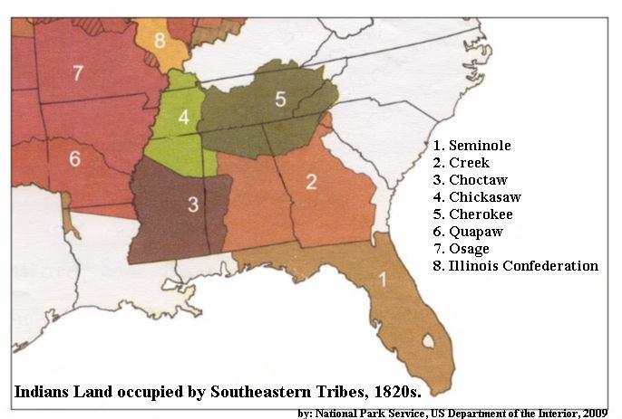
I'm no expert of Native American history, so if anyone is more qualified, please correct me. However, here's a good source as to how the Five "Civilized" Tribes were located in the beginning of the nineteenth century (I'm sure this is also following some southern movement by the nations, but this would be a good reference as to where they'd go even without the Trail of Tears):
Beyond that, I'd recommend changing the "Cahokia Nation" to instead by the Illinois Confederation - which did own a large portion of the land you depicted the Cahokia with.
Of course, there are some things I find a tad bit off with the POD (such as how the French and British were willing to ally in face of Scandinavia and Spain, especially seeing as the POD is within two decades of the Hundred Years' War, especially since it took arguably until the end of the nineteenth century in real life for the British and French to stop staring icicles into each other), but I've probably rambled on a bit too much at this point.
whats society like and whats the tech level?Yes, it is a zombie virus, but my own version of it; it's pretty much a digestive system version of the Romero zombie (meaning the virus is also waterborne to a degree) with a longer incubation/carrier period. These changes are pretty much so the only threat isn't the hordes of undead.
The plague started in the Biafra region and spreads rapidly across the Guinea Coast (with the Sahara and Congo being quite effective barriers). From here it spread to the America's (mostly the Caribbean and Brazil, but also the USA) and then into Europe. You are right in that the America's and West Africa are doing much worse.
damein fisher
Banned
whats society like and whats the tech level?
It really varies on the type of technology. For example, practical motors aren't invented yet, but the Telegraph and revolver are invented earlier. Overall, the tech level is around 1830's in 1855. As for society, it super depends on the nation in question.
So I'm somewhat likely to do some funky East Germany border stuff, but here's another one I thought of:

We have the NATO-aligned Federal Republic of Germany and then the Warsaw Pact-aligned German People's Republic and the South German Democratic Republic. I guess you could say it's kind of a German wank, but in a weird sense
We have the NATO-aligned Federal Republic of Germany and then the Warsaw Pact-aligned German People's Republic and the South German Democratic Republic. I guess you could say it's kind of a German wank, but in a weird sense

guys whatr if the mediteranian was in eyrope!!!! lol!!!!!
No way.
I can't unsee the Aegean-Essos connectionWait, it the bottom one Essos from ASoIaF?
So I'm somewhat likely to do some funky East Germany border stuff, but here's another one I thought of:
We have the NATO-aligned Federal Republic of Germany and then the Warsaw Pact-aligned German People's Republic and the South German Democratic Republic. I guess you could say it's kind of a German wank, but in a weird sense
Why did the Soviets support the Sudeten Germans, rather than the Czechoslovak government in their planned expulsion of them?
Why did the Soviets support the Sudeten Germans, rather than the Czechoslovak government in their planned expulsion of them?
Stalin is less evil/ Hitler is assassinated in '44, I imagine.
Maybe the Allies attached Austria to FRG, and in response the Soviets drew up a plan to have a claimant counterweight with a sizable economic/political/cultural power base to challenge the idea?Stalin is less evil/ Hitler is assassinated in '44, I imagine.
Now imagine my anguish when CA went with the cliche and did Total War: Three KingdomsThere should be a strategy game for those periods.

I mean, it was obvious any China title was going to be Three Kingdoms, but still. I'd kill for something like Total War: Rebellion of the Five Hu (a chance to do Attila right), or Total War: Song Dynasty (gunpowder! Jurchen cataphracts! Epic sieges! Mongols!).
So happy that pixel art seems to be catching on again.It's March 1925 and the spark of the revolution has been lit in Britain. Germany, meanwhile, is preparing to "secure" the British colonies scattered throughout the world.
View attachment 446523
Last edited:
I made this thing to kill time, but it looked kinda good in the end so I decided to post it. No timeline or POD.
Greater France coexists with Greater Germany? And a balkanized North America? Instant like!
Oder-Niesse line makes no sense heren Stettin Nd Frankfurt om the Ofer should remain district centers.with hinterlands on both sides of the Oder riverSo I'm somewhat likely to do some funky East Germany border stuff, but here's another one I thought of:
We have the NATO-aligned Federal Republic of Germany and then the Warsaw Pact-aligned German People's Republic and the South German Democratic Republic. I guess you could say it's kind of a German wank, but in a weird sense
The map just has the national borders between the Germans and North Slavs changed. Just looking at the border with Poland and you can see where small chunks remain, almost like Posen-West Prussia had been revived and expanded southwards. Heck, look at he borders of Austria, and how the largest provinces takes land from Czechoslovakia, but the smaller Danube province doesn't get a speck. And the East Germans or Austrians even claim all of South Tyrol... Hell, they even have the land the Poles took at the Munich Agreement. Meaning that, if East Germany, West Germany, and Austria combined here, they would have more land than Germany had before the invasion of Poland. Well, not counting Memel.Oder-Niesse line makes no sense heren Stettin Nd Frankfurt om the Ofer should remain district centers.with hinterlands on both sides of the Oder river
Last edited:
Rome can into Kazakstan!
How did you make that one? That’s pretty interesting! Though distorted as well since Australia and such would be further north if anything I’d have thought.Needs to get 'Paris At North Pole' so the North hemisphere has maximum land area, and the South hemisphere has maximum water area.

Also, there is this piece of epicness to consider:

Turnovia, the world but upside down!
Last edited:
the world but upside down!
Wouldn't that just be... the world as it is?
- Status
- Not open for further replies.
Share: