SPANISH MOROCCO CAN GO BOIL ITS HEADO U T R A G E O U S L Y F R E N C H
H O N H O N H O N
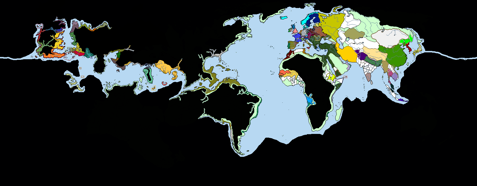
R.I.F Spain

SPANISH MOROCCO CAN GO BOIL ITS HEADO U T R A G E O U S L Y F R E N C H
H O N H O N H O N


Also no Mongol invasions, so the Germans in Russia went through a bit of a golden age and now the region is a pretty thorough mix of Germans and Slavs.
Why does everyone support the Drang Nach Osten?
Interesting scenario: is this part of a larger setting, or a one-off? Love the effort put into the alt-names.
(An "old Burgundy" controlling northern Italy is a cool idea, but wouldn't it have trouble colonizing the Americas if one of its competitors (the Moors) was sitting on the throat of the Mediterranean?)
. But I think it's just a natural progression of Ostsiedlung. Plus the idea of European Russia being a mess of Slavic, German and Finnic principalities fascinates me, particularly without the Mongols storming through and killing everyone. If I were to do another map it'd probably be on that. I like big ethnic hodgepodges (hence why it's on my bingo card, aha). How did Denmark lose Greenland (and not have the Norwegians making a claim to at least a portion of it like their did with Erik the Redland) and why are they and the Norwegians under he French aegis? Seems like it would be tempting fate against the Germans, and the Danes were pretty much just hoping to keep neutral in everything.
This guy's book would make an awesome alternate history book OTL
Sorry, this is a bit anachronistic. It's empire of this man.Like the Timurids ending up in Northern Russia, of all places.
Of course! Can you imagine Azerbaijan without warm water port?AZERBAIJAN HAS WARM WATER PORT.
Thank you.THIS MAP IS LOVE, this map is LIFE
No, it isn't. I didn't play in this game. But the idea is interesting.is that a doki doki reference?
*Free Cities."Free City?"
Thank you.The first thing I saw was the Malta wank, and like, that seemed pretty cool, I was interested, and then I looked over to Asia and WOW.
It's the interesting idea too.I thought that said "Emirate of Japan" and was fully prepared to accept it, with the rest of the map as it was.
It means "It's only Romania, nothing more. And it's not a great Romania or weaker Romania, it's just Romania.".Does "Just Romania" mean "It's only Romania, nothing more" or does it mean "Romania is a place of JUSTICE!" Maybe a bit of both?
This guy's book would make an awesome alternate history book OTL
I bet his name was Phileas Fogg
...I'm not mad, I'm just disappointed.
How did that come about?
As long as the capital's in Dover!
Along similar lines to North and South Dakota. Maryland has shown some interest in getting rid of the Eastern Shore, and the Democrats in office wanted to increase their majority, so Delmarva seemed like a reasonable way to go about doing that.
I’ve been thinking about this map more, and I just realized that this would make a great EUIV mod. The only thing that would need to be done is to fix the projection of the map in order to fit everything in, but imagine exploring Essos/Westeros as a European power.
I believe he used an online mapmaking tool called Mapchart, fit to make information-based maps. alternate history maps? Not so much.Any specific reason for why the borders confirm to OTL, modern day divisions?
His C drive may be filled up, preventing the use of paint or paint.net. I suffer from the same problem, my C drive is filled up for no reason.I don’t know why he didn’t make a real map.