Map Thread XVIII

Status
Not open for further replies.

Hapsburg

Banned
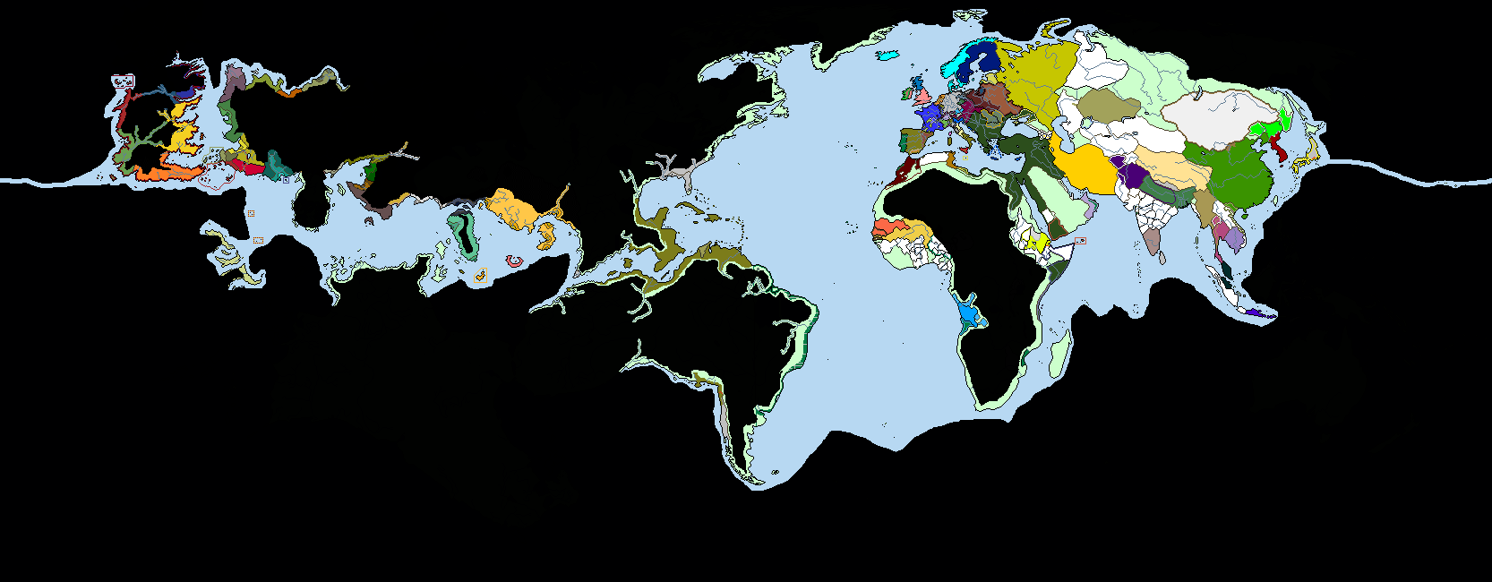
The year 830 of the Imperial Calendar was a dark time for the western lands. The Orcs had mobilized their entire hordes into a full-scale war, adopting tactics and discipline the likes of which had not been seen in centuries to brutal effect. By 830, they had overran most of Balendor, Eldorei, Lilhadorei, Lithuar, Athuasua, and Suatha. The human kingdoms to the south had mostly held off complete collapse, but the years of being cut off from their capital had sown discord among the Ripanians; with the capital under siege and surrounded by Orcish armies, the Ripanian nobles held a patchwork stronghold in the southern Athua Valley. Tolossia, previously a strong kingdom, was bisected by the orcish attacks, seeking to cut them off from their eastern allies. The eastern quarter was occupied by the Etusans, ostensibly to enable better defense against the Orcs but the occupation was not without its depredations on the local populace. To the west, the Orcs threatened the highly urbanized lake region where lay the capitals of the Balendrian and Doreian kings, constantly raiding but not fully prepared to lay siege to such powerful cities. Their northeastern horde had surprised everyone, however, by reorienting themselves first as mountaineering attackers, crossing the high peaks of the West Mountains to invade Vilyafana, and then adapting again to the riparian wetlands with dismounted, bushwhacking tactics.

Further west, the elven Kingdom of Eldunari played its own political games, staying neutral in the Orcish crisis and instead focusing on a series of conflicts with its southern neighbors. A brushfire war between two human tribal kingdoms, Baia and Alam, acted as a pretext for Eldun intervention, which in turn prompted a response by the allies of the invaded Baia. The well-drilled army of Eldunari ran roughshod over their opponents initially, but the Baia surprisingly held out in a brave defense of their core region. The Eldun army attempted a different strategy, effecting a naval invasion of the nearby isles and then a landing on the eastern shore of [insert elven state here], advancing close to their capital. The war stalled by 830 into a stalemate, with both sides conducting raids for attrition, pillaging the countryside, but never really holding any additional territory for any length of time. The Eldunari royal council became tired of the grueling, expensive conflict with little gain; their sons and daughters were highly likely to die in battle, and the economic crisis caused by most of Eldunari's trade being severed war severely impacting stability. The Orcs to the north were increasingly viewed as a serious threat, as they advanced upon the Dorei estuary.

Little did they know, the following year would be a watershed in the entire conflict.

830.png
 
Last edited:
@Ziuwari
TBH, there's some issues with southern France in your map.
The situation is arguably particularly complex, but some principalities shouldn't even be represented in this map, such as the junior Trencavel branches' holdings.
There is some borders issues in Provence, such as Forcalquier's (which is arguably hard to really well depict).

Which source did you used?

Well, if you got a accurate source that would represent the borders better - i'll change it accordingly. If its a good source.
I used a bunch of different maps after a few google searches - and yeah, they aren't really good. Searched for Crown of Aragon and County of Toulouse.
 
Well, if you got a accurate source that would represent the borders better - i'll change it accordingly. If its a good source.
I used a bunch of different maps after a few google searches - and yeah, they aren't really good. Searched for Crown of Aragon and County of Toulouse.
This one isn't bad
Here's for Provence (note the eastern border of the County of Provence is, of course, only vaguely delimited in treaties)
There's more detailed maps in my atlas history books, I'll try to get a numerisation tommorrow.

Basically the lands that were pledged to the King of Aragon before 1209, were the viscounties of Carcassès et Razès, Gavaudan being a place where the King of Aragon was lord (even if he had to increasingly admit the episcopal power in the county's matters) of but he pledged to the Count of Toulouse. Montpellier is a bit of a special case too as it was held by the kings without a particular hommage in the XIIIth, even if Capetians argued it was part of the kingdom; still the power was effectively shared (if not overtaken) with a strong consulate.

With the added complexity that while having held hommage to Aragon very briefly during the Crusade,Toulouse passed most of itstime fighting against Aragonese-led coalitions (such as in during the Great Southern War, and during earlier conflicts)
I made, a long time ago, a really basic map to highlight the network of fidelities in the region just before the Crusade.
 
@LSCatilina I have an aside query on Anduze: the Lords of Anduze are often referred to as Prince, is that reflective of an actual (separate or additional) rank? Did a Principality of Anduze actually exist? Or is it more in the nature of an honorary title without actual privileges or responsibilities?
 
@LSCatilina I have an aside query on Anduze: the Lords of Anduze are often referred to as Prince, is that reflective of an actual (separate or additional) rank? Did a Principality of Anduze actually exist? Or is it more in the nature of an honorary title without actual privileges or responsibilities?
It's more the case of a powerful noble taking an honorary title : of course in the period, the nobiliar titles weren't fixed or truly hierarchized, that happened much later. Especially that it was effectively self-granted.
Note that the title of prince wasn't just used by the lords of Anduze, but even by smaller lords in an attempt to stress their power and make reference to Antiquity.
Ah so it is more the sense of the Lord taking the general prince title and self aggrandising. Thanks.

The way the hierarchy system established itself is fairly interesting, especially the way that Duke was originally sort of lesser than Count but became greater in rank.

I think we also need more "delphinus/dauphin" type titles e.g. Lion of Flanders, Crancelin of Saxony, :p
 
This one isn't bad
Here's for Provence (note the eastern border of the County of Provence is, of course, only vaguely delimited in treaties)
There's more detailed maps in my atlas history books, I'll try to get a numerisation tommorrow.

Basically the lands that were pledged to the King of Aragon before 1209, were the viscounties of Carcassès et Razès, Gavaudan being a place where the King of Aragon was lord (even if he had to increasingly admit the episcopal power in the county's matters) of but he pledged to the Count of Toulouse. Montpellier is a bit of a special case too as it was held by the kings without a particular hommage in the XIIIth, even if Capetians argued it was part of the kingdom; still the power was effectively shared (if not overtaken) with a strong consulate.

With the added complexity that while having held hommage to Aragon very briefly during the Crusade,Toulouse passed most of itstime fighting against Aragonese-led coalitions (such as in during the Great Southern War, and during earlier conflicts)
I made, a long time ago, a really basic map to highlight the network of fidelities in the region just before the Crusade.

Thanks for maps and the additional input and i'll try to use this to rework the map as accurat as possible - but that will take some time. Just like the Britain map, i think i got most of it a bit more accurat but i didn't change everything and i'm currently thinking of a way to put the Hidages in. What i mean to say with this is basically that its possible i have to rework the whole map and adapt everything and that takes just an amount of time that i mostly don't have for everything. But the maps you linked me are quite good and i think changing it based on them could be easier then changing the Britain map - but i have to take time and see trough this all and than i can definitely say if its easy or not.
 
Thanks for maps and the additional input and i'll try to use this to rework the map as accurat as possible - but that will take some time. Just like the Britain map, i think i got most of it a bit more accurat but i didn't change everything and i'm currently thinking of a way to put the Hidages in. What i mean to say with this is basically that its possible i have to rework the whole map and adapt everything and that takes just an amount of time that i mostly don't have for everything. But the maps you linked me are quite good and i think changing it based on them could be easier then changing the Britain map - but i have to take time and see trough this all and than i can definitely say if its easy or not.
At the end of the day it's whether you want it accurate enough for commercial or academic purposes, or if you're just doing it as an exercise in map making.
 
At the end of the day it's whether you want it accurate enough for commercial or academic purposes, or if you're just doing it as an exercise in map making.

True, but its seems as you misunderstood my point: You do realise that making such maps is a lot of work? And re-doing/re-working one might take a great portion of the time making the previous one.
 
True, but its seems as you misunderstood my point: You do realise that making such maps is a lot of work? And re-doing/re-working one might take a great portion of the time making the previous one.
That's precisely my point. If it's commercial then you need to put the effort in. If it's not then it's up to how accurate you want it to be based on the effort to put in.
 
That's precisely my point. If it's commercial then you need to put the effort in. If it's not then it's up to how accurate you want it to be based on the effort to put in.

But thats not my point - my point just was that it will possibly take some time to redo it - not that i don't to redo it.
 
Oh, your post came across as "it's too much effort for me to make the maps accurate" hence my response about how accurate it needs to be.

No, if it came across that way then i'm sorry. What i was trying to say was just that its possible that it will take much time to adapt the map accurately so just don't expect it done tomorrow.
 
No, if it came across that way then i'm sorry. What i was trying to say was just that its possible that it will take much time to adapt the map accurately so just don't expect it done tomorrow.
No worries.
I apologise if I gave the impression of wanting instant correction.
 
As a Marylander through and through, I wholeheartedly approve their annexation of most of the rest of the Delmarva peninsula.

REEEEEEEEEEEEEEE *angry Delawarean noises*

I'm not sure if this is better for both of you, but the peninsula is technically it's own state.

Was there a *TVA?

I can't imagine that there wouldn't be. It just makes too much sense to build a network of dams in the area. That said, the CSR's version of the TVA would have naturally developed earlier than OTL's as a part of its early industrialization efforts rather than as a response to an alt-Depression.
 
Top
Status
Not open for further replies.
Top