Battle Cry of Freedom

Cities will definitely be added to the final product but I don't have any handy at the moment.
Ah. Then MAYBE the elevation would make it too crowded but I guess if you have it handy you can always see how you like it once the cities are done.

That's a fair point on the borders, but the final map will have no unmapped areas.
In that case I think it’ll look great.

Thank you for the feedback, I appreciate it!
Of course, happy to help. Love to see a fellow chronic project hopper finally put out a proper TL
 
Ah. Then MAYBE the elevation would make it too crowded but I guess if you have it handy you can always see how you like it once the cities are done.


In that case I think it’ll look great.


Of course, happy to help. Love to see a fellow chronic project hopper finally put out a proper TL
Screen_Shot_2024-03-06_at_9.54.47_AM.png
On today's episode of Jake Procrastinates the Map of the Month Again:
- Tweaked Canada's borders slightly
- Axed the Maritime Union for now
- Added some cities to see how things look (the cities on the final map will probably be less dense than how I have them here)
None of this stuff is necessarily canon either, I just really don't want to get started on 19th century Europe
 
I've been in a slight rut with regards to the timeline– the visual aspect of Europe map is going well so far (sneak peek coming soon!) but since BCF is “soft” alt-hist, I’m just not sure when I should start diverging from OTL in Europe. I’m not opposed to adding changes that don’t specifically derive from the POD (Connecticut getting Long Island in the mid 1600s), but I don't know much about this period in world history.

Because of North America being canon to the late 1700s, I know that Europe cannot have changed drastically (i.e., the War of the Spanish Succession and the Seven Years' War similar if not identical outcomes to OTL), but I'm still open to minor changes. I'd like to pose this question to any Europe knowers: are there any semi-plausible changes to the continent between 1700 and 1800 that you’d like to see me include? I would appreciate suggestions that (preferably) don’t butterfly the French Revolution and Napoleon away.
Have Joseph II of Portugal survive and the Pombaline reforms be kept, making Portugal a stronger country. This POD IMO is not enough to alter European history but enough to change the future development of Portugal and its colonial empire.
Joseph II died of smallpox in a time where the vaccine already existed, so the POD is simply that his mother allows him to be vaccinated against the disease
 
1804.png

The sneak peek for March's map of the month, as promised! The date for this map will most likely be late 1804, coinciding with Napoleon's coronation.

The biggest issue I have with this map is probably the Levant, the borders look really scuffed to me but I'm not really sure what I should do instead. The general idea is that Ali Bey al-Kabir's campaign against the Ottomans is successful (since his main general doesn't backstab him ITTL), leading to a shaky independent Egypt in the last decades of the 18th century. A Franco-Ottoman invasion of Egypt occurs in 1798-99 since I imagine the Directory and Napoleon would have had similar goals as they had IOTL, the disruption of British power in India and, for the Directory, the desire to keep Napoleon away from the metropole.

Does this make sense to y'all, or should I rework the Egypt/Levant lore? And, if I do keep the lore the same, should I tweak the borders at all?
 
Last edited:
Untitled1172_20240320102019.png

I'm getting close to finishing the 1804 map for March, but before I add the finishing touches, does the labels' information seem accurate to y'all? I understand the labels' formatting is strange at times, but that's not my main concern due to it being a quirk of the map I took inspiration from.

Looks right to me, other than that Algeria might more commonly be labelled “Algiers” at the time IIRC tho I could be wrong.

Montenegro looks bigger than IOTL at the time. Any lore there?
 
Looks right to me, other than that Algeria might more commonly be labelled “Algiers” at the time IIRC tho I could be wrong.

Montenegro looks bigger than IOTL at the time. Any lore there?
My map might just be wrong for Montenegro– the farther east you go, the shakier my sources become. I don't have any lore reason why it's larger than IOTL, do you have a good basemap for me to use? This map is set in late 1804 if that helps, and thank you for the heads-up!
 
My map might just be wrong for Montenegro– the farther east you go, the shakier my sources become.
Fair, its a tiny blob on most maps and is thus rarely clearly depicted even in historical sources, especially since the territories of the various clans that came under the Prince-Bishop's rule are far from clearly defined.

I don't have any lore reason why it's larger than IOTL, do you have a good basemap for me to use?
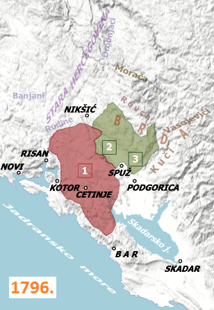
This first one is fairly accurate, very detailed, and is the one I prefer, but the second one shows you just how unclear territory was (the green blob on it corresponds to the area labelled 1796 on the first map and you can see they're quite different in terms of things like how close they get to Nikšić.

bb4ujygndxe41.jpg
1_Stara_Crna_Gora_2_Bjelopavlici_i_3_Piperi_1796_34c.png


This map is set in late 1804 if that helps
Yep, I saw the date.

and thank you for the heads-up!
No problem, happy to help.

Things I want to mention:

  1. At this point the green/1796 area is kind of a distinct political unit within Montenegro, called the Hills or Highlands. It wasn't necessarily an administrative division but there was a distinction between the Old Montenegrins and the Highlanders and the state formally changed its name to The Metropolitanate of Montenegro and the Highlands after integrating it so it is a notable distinction at least for a time
  2. If you have various PODs in the mid 1700s, you could do something with Li'l Steve if you are so inclined. Certainly among the most interesting things going on in Montenegro at the time. Beyond him, there were various schemes floating around about staging a war for Serbian liberation out of Montenegro with Russian support, and an a balancing act between Russian and Venetian influence and lots can happen with the noble family who served as Venice's representatives (Guvernaduri), the Radonjići who would be a problem for later rulers of Montenegro.
 
Last edited:
Fair, its a tiny blob on most maps and is thus rarely clearly depicted even in historical sources, especially since the territories of the various clans that came under the Prince-Bishop's rule are far from clearly defined.


This first one is fairly accurate, very detailed, and is the one I prefer, but the second one shows you just how unclear territory was (the green blob on it corresponds to the area labelled 1796 on the first map and you can see they're quite different in terms of things like how close they get to Nikšić.

bb4ujygndxe41.jpg
1_Stara_Crna_Gora_2_Bjelopavlici_i_3_Piperi_1796_34c.png


Yep, I saw the date.


No problem, happy to help.

Things I want to mention:

  1. At this point the green/1796 area is kind of a distinct political unit within Montenegro, called the Hills or Highlands. It wasn't necessarily an administrative division but there was a distinction between the Old Montenegrins and the Highlanders and the state formally changed its name to The Metropolitanate of Montenegro and the Highlands after integrating it so it is a notable distinction at least for a time
  2. If you have various PODs in the mid 1700s, you could do something with Li'l Steve if you are so inclined. Certainly among the most interesting things going on in Montenegro at the time. Beyond him, there were various schemes floating around about staging a war for Serbian liberation out of Montenegro with Russian support, and an a balancing act between Russian and Venetian influence and lots can happen with the noble family who served as Venice's representatives (Guvernaduri), the Radonjići who would be a problem for later rulers of Montenegro.
I'll be sure to keep all this in mind, thanks again for all your help! My plan is to post the finished map sometime Saturday and then immediately pivot back to the Americas, so keep y'all's eyes peeled for that
 
"Don't worry, the April map is going great so far!"
The map in question:
Screen_Shot_2024-04-01_at_8.30.11_PM.png

(All jokes aside, I should have the projection dialed in by tomorrow)
 
Screen_Shot_2024-04-21_at_9.44.45_PM.png

Howdy, I promise I haven’t abandoned the TL, my senior classes are just going crazy (I have to write 37 pages in 6 days). But, nonetheless, the grind continues– here’s April’s map thus far, likely complete by Tuesday morning.
 
Top