Absolutely. Planning needs to take phasing and sequencing into account to arrange time, space and forces correctly. However, my complaint with some discussion on this board is that many think of various spatial, geographic, terrain factors too deterministically as absolute dictators over doing campaigns in a strategic direction or not, when they are simply *challenges* one needs to compensate for, and you should not assume your enemy would never figure out how, or that you never could.Correct. for the better part of 25 years I was paid to study, think about, plan, and execute such operations. The landing operations or beach assault is about 10% of the effort in a brigade, corps, or army size over the sea operation. The rest of the effort is in preparation and follow up. Just loading a ship correctly for shore to shore or a ship to shore oepration. is a unique skill set that ordinary armies, or merchant marine skippers don't have. The 700 or 800 tons per day you need to sustain a small corps of 25,000 or 35,000 men is not the same 800 mix of items you load at the start or load at many points along the time span of a amphibious operation. Screw that up and you lose 12,000+ men to starvation as the Japanese did on Guadalcanal.
You are using an out of date browser. It may not display this or other websites correctly.
You should upgrade or use an alternative browser.
You should upgrade or use an alternative browser.
What if Japan attacked the Dutch East Indies in 1936?
- Thread starter raharris1973
- Start date
The British and French have to deal with the rise of Japan and have to defend their Asian/Pacific territories which is going to make it that much harder to rearm and defend against any major player in Europe.
A deep dive into the history of British strategic thinking and military preparations in the 1920s - 1930s is worthwhile here. Until 1937 - 1938 Germany, the USSR, Italy, and Europe in General were very low priorities. Italy was not even regarded as a probable enemy until 1937. This is reflected where the Royal Navy was spending its best money in the 1930s. Singapore was upgraded as a major fleet base, the new BB class designs were oriented towards a pacific war, the T Class submarines were designed for the Pacific. The Brit intelligence services were hardly aware the German Enigma encryption system existed, but they were actively intercepting and attacking Japanese radio codes. Between 1925 & 1938 the British war plans for Japan were the best developed and supported of the lot, much like the US. In British strategic thinking any Japanese effort to acquire territory, strategic locations, resources, and other nations colonies south of the Pacific Equator would be immediately regarded as a significant long therm threat to British interests. The Japanese would have to go into this under the assumption that Britain would actively support the Dutch.
It is interesting you will entertain more adventuresome ideas about earlier, more aggressive Allied landings, including D-Day, when so many are happy to point to a single factor (air superiority, landing craft, fighter cover, logistics, shipping) as shorthand without further explanation and declare “can’t do it any earlier than historical”.Correct. for the better part of 25 years I was paid to study, think about, plan, and execute such operations. The landing operations or beach assault is about 10% of the effort in a brigade, corps, or army size over the sea operation. The rest of the effort is in preparation and follow up. Just loading a ship correctly for shore to shore or a ship to shore oepration. is a unique skill set that ordinary armies, or merchant marine skippers don't have. The 700 or 800 tons per day you need to sustain a small corps of 25,000 or 35,000 men is not the same 800 mix of items you load at the start or load at many points along the time span of a amphibious operation. Screw that up and you lose 12,000+ men to starvation as the Japanese did on Guadalcanal.
I wonder if the Japanese knew it though. What intel did the Japanese have on the British planning? We could surmise they knew they were ditched by the Brits with the abandonment of the bilateral alliance in 1922. But, Japanese naval planning, war gaming, at least with level of detail, seemed more America focused with not much attention to Singapore or even Hong Kong before the big China war in 1937, I think. The British construction investment in Singapore would have been visible at least though.A deep dive into the history of British strategic thinking and military preparations in the 1920s - 1930s is worthwhile here. Until 1937 - 1938 Germany, the USSR, Italy, and Europe in General were very low priorities. Italy was not even regarded as a probable enemy until 1937. This is reflected where the Royal Navy was spending its best money in the 1930s. Singapore was upgraded as a major fleet base, the new BB class designs were oriented towards a pacific war, the T Class submarines were designed for the Pacific. The Brit intelligence services were hardly aware the German Enigma encryption system existed, but they were actively intercepting and attacking Japanese radio codes. Between 1925 & 1938 the British war plans for Japan were the best developed and supported of the lot, much like the US. In British strategic thinking any Japanese effort to acquire territory, strategic locations, resources, and other nations colonies south of the Pacific Equator would be immediately regarded as a significant long therm threat to British interests. The Japanese would have to go into this under the assumption that Britain would actively support the Dutch.
Last edited:
And from the late 19th century already, Japan was numbered among the potential attackers, possibly the leading one? Like from after it showed off beating China in 94-95?From the late 19th century out. This was in part caused by the military weakness of the Dutch forces in the DEI. A deliberate attack was unstoppable, while a defense against a coup-de-main had some chance of succeeding, so the latter was chosen as the most likeliest scenario.
Or were Germany, France, Boer-baiting Britain, and greedy island-grabbing Yankee-land seen as the primary threats at first, before Japan ever came to mind?
That would make a lot of people in Europe very upset. The japanese would find themselves at war with the Duch,British and French. They would be facing the full might of those nations because Nazi Germany would not be involved , on Japan's side at least. You could see German volunteer units fighting for the Duch "in the spirit of Arian brotherhood ".
I remember being a bit surprised that the gunnery officer of the HrMs Java was lauded as being the best of the best, and trained his gun crews very well, while Java scored barely a hit - AFAICT - at Java Sea. Interesting to see that this isn't something that was only noticeable in the RNLN.Everyones gunnery early in the war was abysmal. Some improved faster than others. One of the reasons Scotts cruiser force survived his October 1942 battle off Guadalcanal was he had put his little group through a crash course in gunnery in the weeks before the fight. For two decades most navies overestimated the value of the training they did do, and fiscally conservative governments underfunded training. Neither the US or Japan were exceptions.
Good one, didn't consider the lack of the the Long Lance!The surface battle successes of the IJN in 1941 - 1942 had a lot to do with the Type 93 Long Lance torpedo. Those were operational in very limited numbers in 1936. Strip out the hits of the Japanese torpedos in 1942 and the battles outcomes look very different. With that weapon available in limited numbers in 1936 the Japanese will either be overconfident, or have to use more careful and calculated tactics.
The UK was a big threat of course. This because it was the absolute naval top dog and because it had been the last entity to occupy the archipelago during the Napoleonic Wars. At the turn of the century both Japan and China were seen as the upcoming adversary and Yellow Peril, with Japan seen as no. 1 enemy after the Russo-Japanese War.And from the late 19th century already, Japan was numbered among the potential attackers, possibly the leading one? Like from after it showed off beating China in 94-95?
Or were Germany, France, Boer-baiting Britain, and greedy island-grabbing Yankee-land seen as the primary threats at first, before Japan ever came to mind?
The British preferred close range as their decisive range band, with a desire to close to 15,000-16,000 yards. The Brits themselves estimated they would lose a battleship per four enemy battleships firing during the run-in from 34,000 to 20,000 yards.I don't know about Brit naval gunnery doctrine. The USN doctrine in that era was to close into midrange as rapidly as possible. A broad midrange band was regarded as the sweet zone. Both for reasons of gunnery with the US 14" & 16" cannon, and the calculations for resistance of the USN standard BB armor. Did the British make a similar calculation?
The surface battle successes of the IJN in 1941 - 1942 had a lot to do with the Type 93 Long Lance torpedo. Those were operational in very limited numbers in 1936. Strip out the hits of the Japanese torpedos in 1942 and the battles outcomes look very different. With that weapon available in limited numbers in 1936 the Japanese will either be overconfident, or have to use more careful and calculated tactics.
Ultimately, until after 1937 the Brits were badly underestimating the Japanese. It wasn't until 1937 that reports came in that the Japanese intended to open fire at 30,000 yards instead of 22,000 or 23,000; in fact this was still underestimating the Japanese, who intended to open fire at over 38,000 yards. The British were also unaware of the speed increases from the modernizations. In any case, ideal Japanese range was 24,000 yards to 20,800, to maximize the effect of their diving shells.
No. What I do think is that by the time the British can get heavy forces in-theater the Japanese are likely to have gotten the rest of their battleships, bar Hiei, into fighting condition.You think Haruna, Fuso & Yamashiro could stand up to Hood, Nelson and Rodney?
Play the Ball.Right because the British are stupid enough to trust that they won't change their mind and again their mere presence in the DEI is threat to Singapore and Malaya. This on the level of one 10 year old poking another with a ruler and declaring 'see I'm not touching you' and then being surprised when they get smacked in the face...
Ramontxo
Donor
It's A Long Way To Nagasaki: The Anglo-Japanese War
In 1938 the world had two sources of tension. In Europe Spain was in the second year of its civil war and a embryonic Fascist block was coalescing around the Kingdom of Italy and the ever aggressive German Third Reich. A general European war was feared by all: As diplomats raced to defuse...
www.alternatehistory.com
You may find this TL interesting, as it has an similar scenario
The British preferred close range as their decisive range band, with a desire to close to 15,000-16,000 yards. The Brits themselves estimated they would lose a battleship per four enemy battleships firing during the run-in from 34,000 to 20,000 yards.
Ultimately, until after 1937 the Brits were badly underestimating the Japanese. It wasn't until 1937 that reports came in that the Japanese intended to open fire at 30,000 yards instead of 22,000 or 23,000; in fact this was still underestimating the Japanese, who intended to open fire at over 38,000 yards. The British were also unaware of the speed increases from the modernizations. In any case, ideal Japanese range was 24,000 yards to 20,800, to maximize the effect of their diving shells.
Its a question for naval experts. But, from my career in the field artillery I can do the grunt work of calculating the percentages of likely hits at those ranges. From experience I can say the actual percentage is vanishing small however expert your cannon crews and fire control department. Its possible to make a lot out of the first hits of the Scharnhorts or Geisenau on the Glorious at 28,000 meters or on the Italian BB at even further. But...
The Brits, unlike so many others actually had a serious night fighting doctrine, and demonstrated actual skill at it. The Japanese did to. That and weather means as in reality most gunnery engagements are well under those extreme ranges. Like the USN the Brits took a look at all the factors and formed their doctrine accordingly. The conditions of 1941 are unlikely in 1936, or 1937, and its more likely the RN can use its advantages. Like the USN their general concept was not to rush headlong into a Japanese trap & set them selves up as test targets for Japanese ultra long range gunnery.
1936, IJN didn't have land based aircraft capable of conducting missions to NEI, from any of their possessions. not that it mattered, in your scenario; as KNIL had 6 P-6 fighters, & no forces organized to be capable of defending against 'modern' invaders, in the 'outer' islands.Thanks for the good, valuable ORBAT info
I am a little frustrated with the obsessive, almost monomaniacal, focus on the Taiwan, Indochina, generally South China Sea avenue of approach for nnaval forces and troop convoys and ground-based air support, as if it is the only option. It's not.
You make these statements about geographical/operational constraints without even quoting paragraphs 3,4,5 and 6 of the first post in the thread, even for rebuttal purposes, even though they were written to preemptively address objections/complaints such as yours. Were they TLDR for you? Are you just headline reader/reactors, not post/content readers? I read stuff before I start making arguments.
Do you think the Mandated islands Japan owned from WWI through the entire interwar era, especially the Palau islands in their southwestern portion, did not exist, or somehow could not stage air or naval forces for operations further afield?
Are you saying the lines illustrated on these maps from the OTL WWII Japanese "centrifugal offensive" in Southeast Asia and the western Pacific are lying, deceptive, misleading?
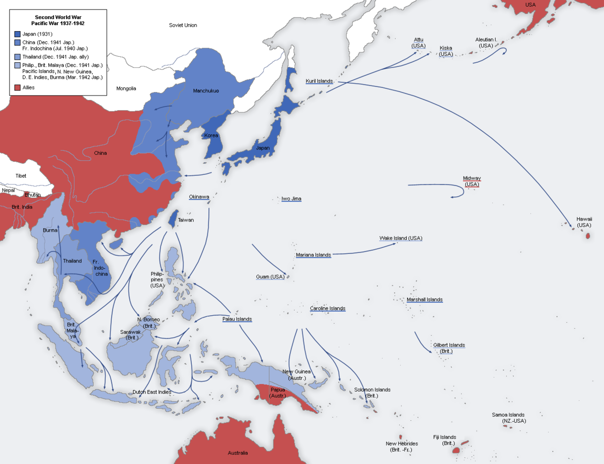
File:Second world war asia 1937-1942 map en6.png - Wikipedia
en.wikipedia.org
With reference to the third map in particular, and Japan's ability to move on the DEI being hamstrung by not having Davao in the Philippines in 1936 (unlike 1942), guess where the Japanese force that took Davao from the American/Filipino forces after Dec. 8, 1941 came from?
The Palau (Pelelieu, Koror, Anguar) an island group the Japanese had owned since 1914. Forces from here also assaulted Legazpi in southeastern Luzon. Both the Davao and Legazpi operations (and early operations from the Carolines in OTL against Australian owned Bismarcks and New Guinea) were conducted at ranges easily reaching several eastern islands of the Dutch East Indies.
Great TLIt's A Long Way To Nagasaki: The Anglo-Japanese War
In 1938 the world had two sources of tension. In Europe Spain was in the second year of its civil war and a embryonic Fascist block was coalescing around the Kingdom of Italy and the ever aggressive German Third Reich. A general European war was feared by all: As diplomats raced to defuse...www.alternatehistory.com
You may find this TL interesting, as it has an similar scenario
Well let's talk turkey and, and get to brass tacks, shall we?1936, IJN didn't have land based aircraft capable of conducting missions to NEI, from any of their possessions. not that it mattered, in your scenario; as KNIL had 6 P-6 fighters, & no forces organized to be capable of defending against 'modern' invaders, in the 'outer' islands.
First off, the bolded second part of your statement is rather important, eh?
"KNIL had 6 P-6 fighters" (I assume this was the 1936 and 1937 figure, was it something higher in 1941-42? - What about in between, like the winter of 1939-40?)
& "no forces organized to be capable of defending against 'modern' invaders, in the 'outer' islands." (I assume this again was the 1936 and 1937 situation, and that one could classify *at least* the Malukus, Keran/Ceran, Sulawesi/Celebes/Manado, and Irian Jaya/West Irian/Western Papua New Guinea as "outer" islands, if not also oil-rich Borneo, home of the Balikpapan and Tarakan oil ports, Timor - indeed just about *all* the islands aside from Java? That would be the lion's share [dragon's share? tiger's?] of the DEI's oil and strategic positions. Again here I do not know how much more protective force was added by KNIL, or KM, by 1941-42, or an intermediate period, like winter-1939-40.)
And in 1936-1937, Japan had multiple aircraft carriers in their fleet, with carrier aviation wings consisting of monoplanes, yes? Certainly not the carriers and carrier aircraft wings of the quality and quantity or combat experience of what they had in 1941-42, but they had them, and they could have been effective in seizing scarcely defended "outer island" targets. Upon which, more substantial ground forces could be shuttled, and where airfields could quickly be prepared for shuttling in of land-based aircraft under naval or army management that could range nearby islands.
Additionally, just what were the combat (heavy opposition) and bombing (light opposition) radii of Japanese land-based aircraft, either in naval service, or army service, in 1936 and 1937? How much had that increased by 1941-42? How much in the interim period by winter 1939-40? I am not certain that targets in the eastern and central Indies, on the northern outliers, like the Malukus, New Guinea's bird's neck peninsula, and Sulawesi's Manado actually were out of range of land-based Japanese aircraft available even by 1936 and based in the Caroline Islands chain or the Palaus chain. [Basing possibilities depend of course airfields having been built, but does anyone have a detailed history of that timing? Japan grew increasingly secretive on the Mandate islands in the 1930s and had sovereignty over them during the interwar for a headstart of airfield and port construction if needed. It did in fact in 1941 send task forces long distances from the Palaus to Davao and Luzon, that I think included air forces. There are parts of the DEI within comparable range. It did in fact send task forces, that I think included air forces in 1941 from the southern Carolines to northern Australian New Guinea and the Bismarcks including New Britain/Rabaul, and comparable distances from Palau could have reached Dutch northwest New Guinea and other DEI islands to its west from the Palaus at least.
Sekhmet_D
Kicked
Principal JNAF bomber in 1936 was the G3M, combat radius about 2200 km. Fighter, A5M, combat radius around 600 km.Additionally, just what were the combat (heavy opposition) and bombing (light opposition) radii of Japanese land-based aircraft, either in naval service, or army service, in 1936 and 1937? How much had that increased by 1941-42? How much in the interim period by winter 1939-40? I am not certain that targets in the eastern and central Indies, on the northern outliers, like the Malukus, New Guinea's bird's neck peninsula, and Sulawesi's Manado actually were out of range of land-based Japanese aircraft available even by 1936 and based in the Caroline Islands chain or the Palaus chain.
For the JAAF, their 1936 era bombers were the Ki-1 and Ki-20, combat radius about 900 km. Fighter, Ki-10, combat radius around 500 km.
The IJN can open fire at 38,000 yards and waste all the shells they want, they arent going to hit anything. Even an exceptional gunnery ship like Warspite only got a hit at 25,000yards
The Brits doctrine basically came down to money. Interwar the they knew the Japanese and Americans increased the elevation on their battleship's main guns. While initially better (20 degrees. 30 from Hood onwards) the Brits got leapfrogged and didn't have the funds to upgrade the whole fleet to 30 degrees. So the question became how to get into shorter range away from the feared plunging shells. Ironically enough they figured fighting at higher ranges was indecisive and against the Nelsonian spirit*, so it all worked out for them until radar made it practical.Its a question for naval experts. But, from my career in the field artillery I can do the grunt work of calculating the percentages of likely hits at those ranges. From experience I can say the actual percentage is vanishing small however expert your cannon crews and fire control department. Its possible to make a lot out of the first hits of the Scharnhorts or Geisenau on the Glorious at 28,000 meters or on the Italian BB at even further. But...
The Brits, unlike so many others actually had a serious night fighting doctrine, and demonstrated actual skill at it. The Japanese did to. That and weather means as in reality most gunnery engagements are well under those extreme ranges. Like the USN the Brits took a look at all the factors and formed their doctrine accordingly. The conditions of 1941 are unlikely in 1936, or 1937, and its more likely the RN can use its advantages. Like the USN their general concept was not to rush headlong into a Japanese trap & set them selves up as test targets for Japanese ultra long range gunnery.
*More about playing for keeps, rather than Elan's martial superiority nonsense. The RN knew how to pay the piper.
@HJ Tulp @Garrison @Carl Schwamberger and everyone else.
Some years back, I made a thread with multiple choices (lots of them, using almost the whole alphabet) to ask just when Japan came to the viewpoint that an attack on one power to its south (the Dutch, the US, or UK) by necessity meant a simultaneous war with all three. I am reopening it, so people can freshly respond to the poll, without it being a necro.
Some years back, I made a thread with multiple choices (lots of them, using almost the whole alphabet) to ask just when Japan came to the viewpoint that an attack on one power to its south (the Dutch, the US, or UK) by necessity meant a simultaneous war with all three. I am reopening it, so people can freshly respond to the poll, without it being a necro.
When did Japanese Navy stop believing they could fight just US or UK or Dutch w/out fighting others?
1) When did Japanese Naval planners stop believing they could fight one of the US or UK or Dutch without fighting the other two? a) Once Americans and other white powers jointly bombarded Japanese ports in 1863 b) Once Britain added the loophole to the Anglo-Japanese Treaty (1911) that...
www.alternatehistory.com
yes, "bolded" part is important.Well let's talk turkey and, and get to brass tacks, shall we?
First off, the bolded second part of your statement is rather important, eh?
"KNIL had 6 P-6 fighters" (I assume this was the 1936 and 1937 figure, was it something higher in 1941-42? - What about in between, like the winter of 1939-40?)
& "no forces organized to be capable of defending against 'modern' invaders, in the 'outer' islands." (I assume this again was the 1936 and 1937 situation, and that one could classify *at least* the Malukus, Keran/Ceran, Sulawesi/Celebes/Manado, and Irian Jaya/West Irian/Western Papua New Guinea as "outer" islands, if not also oil-rich Borneo, home of the Balikpapan and Tarakan oil ports, Timor - indeed just about *all* the islands aside from Java? That would be the lion's share [dragon's share? tiger's?] of the DEI's oil and strategic positions. Again here I do not know how much more protective force was added by KNIL, or KM, by 1941-42, or an intermediate period, like winter-1939-40.)
And in 1936-1937, Japan had multiple aircraft carriers in their fleet, with carrier aviation wings consisting of monoplanes, yes? Certainly not the carriers and carrier aircraft wings of the quality and quantity or combat experience of what they had in 1941-42, but they had them, and they could have been effective in seizing scarcely defended "outer island" targets. Upon which, more substantial ground forces could be shuttled, and where airfields could quickly be prepared for shuttling in of land-based aircraft under naval or army management that could range nearby islands.
Additionally, just what were the combat (heavy opposition) and bombing (light opposition) radii of Japanese land-based aircraft, either in naval service, or army service, in 1936 and 1937? How much had that increased by 1941-42? How much in the interim period by winter 1939-40? I am not certain that targets in the eastern and central Indies, on the northern outliers, like the Malukus, New Guinea's bird's neck peninsula, and Sulawesi's Manado actually were out of range of land-based Japanese aircraft available even by 1936 and based in the Caroline Islands chain or the Palaus chain. [Basing possibilities depend of course airfields having been built, but does anyone have a detailed history of that timing? Japan grew increasingly secretive on the Mandate islands in the 1930s and had sovereignty over them during the interwar for a headstart of airfield and port construction if needed. It did in fact in 1941 send task forces long distances from the Palaus to Davao and Luzon, that I think included air forces. There are parts of the DEI within comparable range. It did in fact send task forces, that I think included air forces in 1941 from the southern Carolines to northern Australian New Guinea and the Bismarcks including New Britain/Rabaul, and comparable distances from Palau could have reached Dutch northwest New Guinea and other DEI islands to its west from the Palaus at least.
the scenario occurs in 1936, so forces available after that year are irrelevant.
'outer islands' = anything not Java & Borneo.
in 1936, IJN had Hosho, Ryujo, & Kaga available for ops, all with bi-plane fighters, dive, & torpedo bombers. A5Ms enter service in 1937.
IJN 'land based' bombers were a product of naval limitation treaties, as a means to provide long range capability. G3M was the first production model, just coming on line in 1936, mostly as test a/c, with 34 completed thru 1936. use for 1936 ops would be minimal; consider them to have 800 nautical miles combat radius. the longest mission for them in december '41 appears to be the, c.640 naut. miles, kwajalein to wake attacks.
Army 'heavy' bomber was the Ki-1; can't find a listed range, of any kind, for it.
also, couldn't find information about any airfields existing before 1944, in Palau; seems only sea-planes stationed there up to beginning of pacific war.
Sekhmet_D
Kicked
Combat radius was only 900 km or thereabouts as I mentioned above. As far as multi engine bombers is concerned, pretty pathetic.Army 'heavy' bomber was the Ki-1; can't find a listed range, of any kind, for it.
Share: